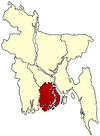
Bakerganj Upazila
Bakerganj
বাকেরগঞ্জ | |
|---|---|
Upazila | |
 Bakerganj Location in Bangladesh | |
| Coordinates: 22°33′N 90°20.3′E / 22.550°N 90.3383°ECoordinates: 22°33′N 90°20.3′E / 22.550°N 90.3383°E | |
| Country | Bangladesh |
| Division | Barisal Division |
| District | Barisal District |
| Area | |
| • Total | 417.2 km2 (161.1 sq mi) |
| Population (2011) | |
| • Total | 313,845 |
| • Density | 750/km2 (1,900/sq mi) |
| Time zone | UTC+6 (BST) |
| Website | Official Map of the Bakerganj Upazila |
Bakerganj (Bengali: বাকেরগঞ্জ) is an Upazila of Barisal District in the Barisal Division, Bangladesh.[1]
Geography[]
Bakerganj is located at 22°33′00″N 90°20′20″E / 22.5500°N 90.3389°E. It has a total area of 417.2 km2 (161.1 sq mi).
Demographics[]
| Year | Pop. (000) | ±% |
|---|---|---|
| 1981 | 312 | — |
| 1991 | 337 | +8.0% |
| 2001 | 354 | +5.0% |
| 2011 | 314 | −11.3% |
| Source: Bangladesh Bureau of Statistics[2] | ||
According to the 2011 Bangladesh census, Bakerganj Upazila had 71,537 households and a population of 313,845, 6.2% of whom lived in urban areas. 10.0% of the population was under the age of 5. The literacy rate (age 7 and over) was 63.3%, compared to the national average of 51.8%.[3][4]
Administration[]
Bakerganj Upazila is divided into Bakerganj Municipality and 14 union parishads: Bharpasha, Charadi, Char Amaddi, Darial, Dudhal, Durgapasha, Faridpur, Garuria, Kabai, Kalashkati, Nalua, Niamati, Padri Shibpur, and Rangasree. The union parishads are subdivided into 149 mauzas and 172 villages.[2]
See also[]
- Upazilas of Bangladesh
- Districts of Bangladesh
- Divisions of Bangladesh
References[]
- ^ Md. Mijanur Rahman (2012). "Bakerganj Upazila". In Sirajul Islam and Ahmed A. Jamal (ed.). Banglapedia: National Encyclopedia of Bangladesh (Second ed.). Asiatic Society of Bangladesh.
- ^ a b "District Statistics 2011: Barisal" (PDF). Bangladesh Bureau of Statistics. Archived from the original (PDF) on 13 November 2014. Retrieved 14 July 2014.
- ^ "Community Report: Barisal" (PDF). Population & Housing Census 2011. Bangladesh Bureau of Statistics. Retrieved 15 August 2018.
- ^ "Population and Housing Census 2011: Bangladesh at a Glance" (PDF). Bangladesh Bureau of Statistics. Archived from the original (PDF) on 28 July 2014. Retrieved 21 July 2014.
- Upazilas of Barisal District
- Barisal Division geography stubs
