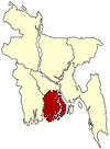
Banaripara Upazila
This article relies largely or entirely on a single source. (March 2020) |
Banaripara
বানারীপাড়া | |
|---|---|
Upazila | |
 Banaripara Location in Bangladesh | |
| Coordinates: 22°46.9′N 90°10′E / 22.7817°N 90.167°ECoordinates: 22°46.9′N 90°10′E / 22.7817°N 90.167°E | |
| Country | |
| Division | Barisal Division |
| District | Barisal District |
| Area | |
| • Total | 134.32 km2 (51.86 sq mi) |
| Population (1991) | |
| • Total | 143,825 |
| • Density | 1,100/km2 (2,800/sq mi) |
| Time zone | UTC+6 (BST) |
| Website | Official website of the Banaripara Upazila |
Banaripara (Bengali: বানারিপাড়া) is an Upazila of Barisal District in the Division of Barisal in southern-central Bangladesh.[1]
History[]
During the Liberation War in 1971, the Pakistani army killed many innocent people[citation needed] of village Gava where all Ghosh Dastidar and Ghosh Ray used to live and they mostly left their ancestral land for good.
Geography[]
Banaripara is located at 22°46′55″N 90°10′00″E / 22.7819°N 90.1667°E. It has 26,697 households and a total area of 134.32 km2.[citation needed] It is surrounded by to the north and the east, Nesarabad to the south, Jhalokati to the east, Nazirpur to the west. The upazila is criss-crossed by many rivers. Banaripara pourashava stands on the Shandhya. River erosion is a matter of concern for this area.[citation needed]
Demographics[]
According to the 1991 Bangladesh census, Banaripara had a population of 143,825. Males constituted 50.67% of the population, and females 49.33%. The population aged 18 or over was 70,724.
Administration[]
Banaripara was established as a thana[definition needed] in 1913 and in 1983 it was upgraded as an upazila[clarification needed].
Banaripara Upazila is divided into Banaripara Municipality and eight union parishads: Baisari, Banaripara, Bisarkandi, Chakhar, Iluhar, Saliabakpur, Saidkati, and Udaykati. The union parishads are subdivided into 76 mauzas and 76 villages.[2]
Archaeological heritage and relics[]
There are two Swathidaha Maths, a copper Manasa Bigraga weighing 3.5 maunds and a six-foot-high Bigraha at Narattampur (200 years old) which used to be family lineage of the Ghosh Ray family of Narratampur.
Education[]
There are three colleges in the upazila. Government Fazlul Huq College, founded in 1940, is the only public one.
There are 27 high schools, 80 government primary schools, 41 non-government primary schools, 59 madrassas, 1 school for the deaf and dumb and 1 commercial school in this upazila.
According to Banglapedia, Baisari High School, founded in 1880, Govt. Banaripara Model Union Institution (Pilot), (1889), and Nalasree Government Primary School (1910) are notable schools.[1]
Maps[]
Official Map of the Banaripara Upazila
References[]
- ^ Jump up to: a b Rahman, Kazi Mizanur (2012). "Banaripara Upazila". In Islam, Sirajul; Jamal, Ahmed A. (eds.). Banglapedia: National Encyclopedia of Bangladesh (Second ed.). Asiatic Society of Bangladesh.
- ^ "District Statistics 2011: Barisal" (PDF). Bangladesh Bureau of Statistics. Archived from the original (PDF) on 13 November 2014. Retrieved 14 July 2014.
- Upazilas of Barisal District
- Barishal Division
- Barisal Division geography stubs

