Bamble
Bamble kommune
Bamble | |
|---|---|
| Bamble | |
 | |
 Coat of arms 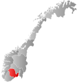 Vestfold og Telemark within Norway | |
 Bamble within Vestfold og Telemark | |
| Coordinates: 59°1′11″N 9°33′39″E / 59.01972°N 9.56083°ECoordinates: 59°1′11″N 9°33′39″E / 59.01972°N 9.56083°E | |
| Country | Norway |
| County | Vestfold og Telemark |
| District | Grenland |
| Administrative centre | Langesund |
| Government | |
| • Mayor (2015) | Hallgeir Kjeldal (Labour) |
| Area | |
| • Total | 304 km2 (117 sq mi) |
| • Land | 282 km2 (109 sq mi) |
| Area rank | 274 in Norway |
| Population (2004) | |
| • Total | 14,163 |
| • Rank | 70 in Norway |
| • Density | 50/km2 (100/sq mi) |
| • Change (10 years) | 0.6% |
| Demonyms | Bambling or Bamling Bemling (archaic)[1] |
| Time zone | UTC+01:00 (CET) |
| • Summer (DST) | UTC+02:00 (CEST) |
| ISO 3166 code | NO-3813 |
| Official language form | Neutral[2] |
| Website | www |

Bamble is a municipality in Vestfold og Telemark county, Norway. It is part of the traditional region of Grenland. The administrative centre of the municipality is the village of Langesund.
General information[]
Name[]
The Old Norse form of the name was Bamblar (a plural form). The name could be related to the word bembel m 'belly' (used in the meaning 'round hill/mountain'). The name was written "Bamle" in the period 1889–1917.[3]
See also the name Bømlo.
Coat-of-arms[]
The coat-of-arms is from modern times. They were granted on 12 December 1986. The arms show a gold-colored ship's wheel on a blue background. The arms are nearly identical to the former arms of Stathelle, which along with Langesund was merged with the municipality of Bamble on 1 January 1964. Sailing and fishing have always been of great importance for the area, and a ship's wheel was thus an appropriate symbol.[4][5]

History[]
The municipality of Bamble was established on 1 January 1838 (see formannskapsdistrikt). The lading place of Stathelle was separated from the municipality of Bamble in 1851. On 1 January 1964, the municipality of Bamble was merged with the neighboring municipalities of Stathelle and Langesund. The new municipality was named Bamble, the administrative centre was Langesund, and the coat-of-arms of Stathelle were used for the new municipality.[5]
Bamble, lying at the southern tip of the Kongsberg-Bamble geological formation, also has a unique geology that has been extensively researched by geologists such as W. C. Brøgger. It exhibits a high grade gneiss terrane characterized by metasomatism.[6] As such there have been many mines operating in the area, most notably the Ødegården Verk apatite mines and the nickel mines in Nystein.
Bamble Church (Bamble kirke) is located at E18 south of Grenland Bridge. It is a wooden cruciform church which was built in 1845. The church is located next to the ruins of Olav Church which dated to around 1145.[7]
Twin towns – sister cities[]
Notable people[]


- Marcus Olaus Bøckmann (1849 in Langesund – 1942) a Norwegian-American Lutheran theologian in Minnesota
- Marie Høeg (1866 in Langesund – 1949) a Norwegian photographer and suffragist
- William Houlder Zachariasen (1906 in Langeslund – 1979) Norwegian-American physicist, pioneering specialist in X-ray crystallography and the structure of glass in Chicago
- Arne Selberg (1910 in Langeslund – 1989) a civil engineer, designed suspension bridges
- Sigmund Selberg (1910–1994) a mathematician, worked on the distribution of prime numbers
- Atle Selberg (1917 in Langeslund – 2007) a mathematician, worked on analytic number theory
- Kjell Bohlin (1928–2011) a Norwegian politician, Mayor of Bamble 1971 to 1981
- Turid Thomassen (born 1965 in Stathelle) leader of the Norwegian Red party 2010 to 2012
- Sverre Gjørvad (born 1966 in Stathelle) a Norwegian jazz musician (drums) and composer
- Odd Ivar Solvold (born 1969 in Bamble) a chef, restaurateur and author of cook books
- Jørn Lier Horst (born 1970 in Bamble) author of crime fiction and former Police officer
- Kenneth Nilsen (born 1994 in Bamble) stage name K-391 a Norwegian music producer
Sport[]
- Thor Thorvaldsen (1909 in Bamble – 1987) a Norwegian sailor and twice Olympic champion
- Jan Halvor Halvorsen (born 1963 in Bamble) former footballer with 250 club caps and 5 for Norway
- Ella Gjømle Berg (born 1979 in Stathelle) a cross-country skier
References[]
- ^ "Navn på steder og personer: Innbyggjarnamn" (in Norwegian). Språkrådet.
- ^ "Forskrift om målvedtak i kommunar og fylkeskommunar" (in Norwegian). Lovdata.no.
- ^ Rygh, Oluf (1914). Norske gaardnavne: Bratsbergs amt (in Norwegian) (7 ed.). Kristiania, Norge: W. C. Fabritius & sønners bogtrikkeri. pp. 48–49.
- ^ Norske Kommunevåpen (1990). "Nye kommunevåbener i Norden". Retrieved 2009-01-15.
- ^ Jump up to: a b "Kommunens våpenskjold". Bamble kommune. Retrieved 2009-01-15.[dead link] (in Norwegian)
- ^ Nijland, T.G.; Zwaan, J.C.; Touret, L. (Dec 1998). "Topographical mineralogy of the Bamble sector, south Norway". Scripta Geologica. Naturalis. 118: 1–46. Retrieved 18 January 2013.
- ^ "Olavskirken – Skeidi kirke i Bamble". miklaborg.net. Archived from the original on 2016-09-20. Retrieved September 1, 2016.
- ^ "Vennskapskommuner". bamble.kommune.no (in Norwegian). Bamble Kommune. Retrieved 2021-01-31.
External links[]
 Media related to Bamble at Wikimedia Commons
 The dictionary definition of Bamble at Wiktionary
- Municipal fact sheet from Statistics Norway
 Telemark travel guide from Wikivoyage
| hide Vestfold og Telemark county, Norway | |||||||||
|---|---|---|---|---|---|---|---|---|---|
| |||||||||
 | Towns and cities |
|  | ||||||
| Municipalities |
| ||||||||
| Authority control |
|
|---|
- Bamble
- Municipalities of Vestfold og Telemark