Vinje
Vinje kommune | |
|---|---|
 Coat of arms  Vestfold og Telemark within Norway | |
 Vinje within Vestfold og Telemark | |
| Coordinates: 59°48′5″N 7°46′45″E / 59.80139°N 7.77917°ECoordinates: 59°48′5″N 7°46′45″E / 59.80139°N 7.77917°E | |
| Country | Norway |
| County | Vestfold og Telemark |
| District | Vest-Telemark |
| Administrative centre | Åmot |
| Government | |
| • Mayor (2015) | Jon Rikard Kleven (SP) |
| Area | |
| • Total | 3,106 km2 (1,199 sq mi) |
| • Land | 2,732 km2 (1,055 sq mi) |
| Area rank | 12 in Norway |
| Population (2004) | |
| • Total | 3,756 |
| • Rank | 238 in Norway |
| • Density | 1/km2 (3/sq mi) |
| • Change (10 years) | −6.8% |
| Demonym(s) | Vinbygg Vinbygge (male) Vinbyggje (female)[1] |
| Time zone | UTC+01:00 (CET) |
| • Summer (DST) | UTC+02:00 (CEST) |
| ISO 3166 code | NO-3825 |
| Official language form | Nynorsk[2] |
| Website | www |

Vinje is a municipality in Telemark in the county of Vestfold og Telemark in Norway. It is part of the traditional regions of Upper Telemark and Vest-Telemark. The administrative center of the municipality is the village of Åmot.
General information[]
Name[]
The municipality of Vinje (originally a parish) is named after the old Vinje farm (Old Norse: Vinjar), since the first church was built there. The name is the plural form of vin which means "meadow" or "pasture".
See also Vinje, Sør-Trøndelag.[3]
Coat-of-arms[]
The coat-of-arms is from modern times. They were granted on 16 November 1990. The arms show a silver goat on a blue background. It is symbolic of the goat and sheep farming in the municipality.[4]
(See also the coat-of-arms for Aurland.)
History[]
Vinje was established as a municipality on 1 January 1838 (see formannskapsdistrikt). The area of Rauland was separated from Vinje in 1860 to become a municipality of its own. On 1 January 1964 Rauland was merged back into the municipality of Vinje. Rauland has since been part of the larger Vinje municipality. The local traditions of arts and crafts have been well maintained, and Rauland hosts a national academy for arts, crafts and traditional music.
Vinje became a site of heavy battles during World War II, at the Battle of Vinjesvingen when Norwegian forces held out for over a month against superior German forces.
Geography[]
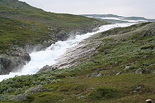
Vinje is situated on both the Hardangervidda plateau and parts of the Setesdalsheiene mountain plateaus. European route E134 passes through Vinje, which is located halfway between Oslo and Haugesund on Norway's west coast.
Starting at Haukeli, Norwegian National Road 9 leads up the steep slopes to Hovden and further south down the Setesdal to Kristiansand.
The mountain ski resort Haukelifjell is also found nearby. The isolated and sparsely populated area is known for its rugged, mountainous terrain that supports a wide variety of outdoor activities, amongst them hiking, mountain biking, snowboarding, skiing, fishing, and canoeing.
Arabygdi lies on Lake Totak in the western part of Rauland. Its famous attraction is the "Urdbøuri", the largest stone scree in Northern Europe, with huge boulders scattered on the floor of the valley.
Notable people from Vinje[]
The Arts[]


- Sveinung Svalastoga (1772 in Rauland – 1809) a Norwegian rose painter, poet and woodcarver
- Myllarguten (Torgeir Agundson Øygarden) (1801–1872) folk musician and master fiddler
- Aasmund Olavsson Vinje (1818–1870) a poet and journalist, used Nynorsk
- Rikard Berge (1881 in Rauland – 1969) a folklorist, museologist, biographer and editor
- Tarjei Vesaas (1897–1970) a Norwegian poet and novelist
- Aslaug Vaa (1889 in Rauland – 1965) a Norwegian poet and playwright
- Aslak Brekke (1901–1978) a vocalist using stev and a folk singer
- Dyre Vaa (1903–1980) a sculptor and painter, his works are found in Oslo and Vinje
- Anne Lofthus (1932–2003) a Norwegian ceramic artist and art teacher
- Guri Vesaas (born 1939) a Norwegian writer and translator of children's books
- Stein Versto (born 1957) a Norwegian poet, novelist, translator and folk musician
- Aasmund Nordstoga (born 1964) a Norwegian musician, singer, composer and TV presenter
- Sven Erik Kristiansen (born 1969) a musician, former vocalist in the black metal band Mayhem
- Arve Moen Bergset (born 1972) a traditional folk singer, hardanger fiddler and classical violinist
- Odd Nordstoga (born 1972) a folk singer, musician, actor and editor [5]
- Ingebjørg Bratland (born 1990) a Norwegian folk singer, kveder and artist
Public Service[]

- Paul Peterson Paus (1625-1682) a Norwegian cleric, political activist and poet
- Olav Aslakson Versto (1892 in Rauland – 1977) politician
- Einar Skinnarland (1918–2002) a Norwegian resistance fighter during WWII and dam builder
- Aslak Versto (1924-1992) politician
- Olav Vesaas (born 1935) a Norwegian journalist, biographer and publisher
- Olav Versto (1950–2011) a Norwegian journalist and editor
- Astrid Versto (born 1953) a Norwegian journalist and diplomat
Sport[]
- Olav Jenssen (born 1962) a discus thrower, competed in the 1992 Summer Olympics
- Knut Tore Apeland (born 1968) a former Nordic combined skier, twice team silver medallist at the 1992 & 1994 Winter Olympics
- Terje Håkonsen (born 1974) snowboarder
Attractions[]
- The home of Myllarguten is now a small museum. (The cotters place Kosi in Arabygdi.)
- The monument of Myllarguten, the 19th century musician, who played for kings and who inspired Edvard Grieg . It is located on the roadside vis-a-vis Kosi.
References[]
- ^ "Navn på steder og personer: Innbyggjarnamn" (in Norwegian). Språkrådet.
- ^ "Forskrift om målvedtak i kommunar og fylkeskommunar" (in Norwegian). Lovdata.no.
- ^ Rygh, Oluf (1914). Norske gaardnavne: Bratsbergs amt (dokpro.uio.no) (in Norwegian) (7 ed.). Kristiania, Norge: W. C. Fabritius & sønners bogtrikkeri. p. 436.
- ^ Norske Kommunevåpen (1990). "Nye kommunevåbener i Norden". Retrieved 2009-01-18.
- ^ IMDb Database retrieved 24 August 2020
External links[]
 Media related to Vinje at Wikimedia Commons
 The dictionary definition of Vinje at Wiktionary
- Municipal fact sheet from Statistics Norway
 Telemark travel guide from Wikivoyage
| hide Vestfold og Telemark county, Norway | |||||||||
|---|---|---|---|---|---|---|---|---|---|
| |||||||||
 | Towns and cities |
|  | ||||||
| Municipalities |
| ||||||||
| show Authority control |
|---|
- Vinje
- Municipalities of Vestfold og Telemark