Banner Elk, North Carolina
Banner Elk, North Carolina | |
|---|---|
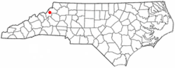 Location of Banner Elk, North Carolina | |
| Coordinates: 36°9′34″N 81°52′18″W / 36.15944°N 81.87167°WCoordinates: 36°9′34″N 81°52′18″W / 36.15944°N 81.87167°W | |
| Country | United States |
| State | North Carolina |
| County | Avery |
| Founded | 1848 |
| Incorporated | 1911 |
| Government | |
| • Type | Mayor-council |
| Area | |
| • Total | 1.92 sq mi (4.97 km2) |
| • Land | 1.92 sq mi (4.97 km2) |
| • Water | 0.00 sq mi (0.00 km2) |
| Elevation | 3,701 ft (1,128 m) |
| Population (2010) | |
| • Total | 1,028 |
| • Estimate (2019)[4] | 1,149 |
| • Density | 598.44/sq mi (231.06/km2) |
| Time zone | UTC-5 (Eastern (EST)) |
| • Summer (DST) | UTC-4 (EDT) |
| ZIP code | 28604 |
| Area code(s) | 828 |
| FIPS code | 37-03500[2] |
| GNIS feature ID | 1018956[3] |
| Website | www |

Banner Elk is a town in Avery County, North Carolina, United States. The population was 1,028 at the 2010 census.[5] Banner Elk is home to Lees–McRae College.
History[]
The area surrounding the Elk River was inhabited by the Cherokee before western settlement, although no evidence of a permanent Cherokee settlement has ever been found. It is likely the area was used for hunting and fishing. The first permanent settlement was established by Martin L. Banner in 1848. Although the Banner family originally came from Wales, Martin Banner moved from Forsyth County in the Piedmont region of North Carolina. Eventually, the Banner family grew to 55 members, and the area where they lived became known as Banner's Elk. This name was later shortened to Banner Elk when the town was incorporated in 1911.[6]
The Banner Elk Hotel and Robert Chester and Elsie H. Lowe House are listed on the National Register of Historic Places.[7][8]
Demographics[]
| Historical population | |||
|---|---|---|---|
| Census | Pop. | %± | |
| 1920 | 264 | — | |
| 1930 | 340 | 28.8% | |
| 1970 | 754 | — | |
| 1980 | 1,087 | 44.2% | |
| 1990 | 933 | −14.2% | |
| 2000 | 811 | −13.1% | |
| 2010 | 1,028 | 26.8% | |
| 2019 (est.) | 1,149 | [4] | 11.8% |
| U.S. Decennial Census[9] | |||
As of the census[2] of 2000, there were 811 people, 215 households, and 124 families residing in the town. The population density was 679.8 people per square mile (263.1/km2). There were 290 housing units at an average density of 243.1 per square mile (94.1/km2). The racial makeup of the town was 90.26% White, 3.95% African American, 0.62% Native American, 1.23% Asian, 0.25% Pacific Islander, 1.23% from other races, and 2.47% from two or more races. Hispanic or Latino of any race were 1.85% of the population.
Of the 215 households, 23.3% had children under the age of 18 living with them, 46.5% were married couples living together, 8.4% had a female householder with no husband present, and 42.3% were non-families. 30.2% of all households were made up of individuals, and 8.8% had someone living alone who was 65 years of age or older. The average household size was 2.13 and the average family size was 2.65.
In the town, the population was spread out, with 10.7% under the age of 18, 47.8% from 18 to 24, 16.8% from 25 to 44, 14.9% from 45 to 64, and 9.7% who were 65 years of age or older. The median age was 22 years. For every 100 females, there were 93.1 males
Geography[]
Banner Elk is located at 36°9′34″N 81°52′18″W / 36.15944°N 81.87167°W (36.159561, −81.871649).[10]
According to the United States Census Bureau, the town has a total area of 1.9 square miles (4.9 km2), all land.[5]
Climate[]
Banner Elk is located in North America's humid continental climate zone due to its elevation, which gives it a climate more like that of Altoona, Pennsylvania, than Asheville, North Carolina, during the winter. During the summer the temperatures are much like a mountain lake town in New Hampshire. The town typically has cold, snowy winters and mild summers.
| hideClimate data for Banner Elk, North Carolina (1991–2020 normals, extremes 1907–present) | |||||||||||||
|---|---|---|---|---|---|---|---|---|---|---|---|---|---|
| Month | Jan | Feb | Mar | Apr | May | Jun | Jul | Aug | Sep | Oct | Nov | Dec | Year |
| Record high °F (°C) | 74 (23) |
75 (24) |
82 (28) |
86 (30) |
89 (32) |
98 (37) |
95 (35) |
97 (36) |
93 (34) |
86 (30) |
76 (24) |
75 (24) |
98 (37) |
| Average high °F (°C) | 40.3 (4.6) |
43.5 (6.4) |
50.4 (10.2) |
60.4 (15.8) |
67.9 (19.9) |
74.0 (23.3) |
76.9 (24.9) |
76.3 (24.6) |
71.3 (21.8) |
62.0 (16.7) |
52.3 (11.3) |
43.9 (6.6) |
59.9 (15.5) |
| Daily mean °F (°C) | 31.2 (−0.4) |
33.9 (1.1) |
40.4 (4.7) |
49.5 (9.7) |
57.7 (14.3) |
64.8 (18.2) |
67.8 (19.9) |
66.8 (19.3) |
61.4 (16.3) |
51.1 (10.6) |
41.5 (5.3) |
34.7 (1.5) |
50.1 (10.1) |
| Average low °F (°C) | 22.1 (−5.5) |
24.3 (−4.3) |
30.4 (−0.9) |
38.6 (3.7) |
47.4 (8.6) |
55.5 (13.1) |
58.7 (14.8) |
57.3 (14.1) |
51.5 (10.8) |
40.1 (4.5) |
30.8 (−0.7) |
25.5 (−3.6) |
40.2 (4.6) |
| Record low °F (°C) | −31 (−35) |
−13 (−25) |
−9 (−23) |
7 (−14) |
19 (−7) |
27 (−3) |
35 (2) |
31 (−1) |
24 (−4) |
8 (−13) |
−7 (−22) |
−21 (−29) |
−31 (−35) |
| Average precipitation inches (mm) | 4.62 (117) |
3.70 (94) |
4.87 (124) |
4.83 (123) |
5.13 (130) |
5.12 (130) |
5.68 (144) |
4.31 (109) |
4.55 (116) |
3.41 (87) |
3.30 (84) |
4.25 (108) |
53.77 (1,366) |
| Average snowfall inches (cm) | 6.9 (18) |
11.4 (29) |
4.8 (12) |
0.8 (2.0) |
0.0 (0.0) |
0.0 (0.0) |
0.0 (0.0) |
0.0 (0.0) |
0.0 (0.0) |
0.1 (0.25) |
1.6 (4.1) |
5.8 (15) |
31.4 (80) |
| Average precipitation days (≥ 0.01 in) | 13.9 | 11.3 | 13.1 | 12.3 | 13.8 | 14.3 | 15.3 | 14.1 | 11.5 | 9.3 | 9.8 | 13.2 | 151.9 |
| Average snowy days (≥ 0.1 in) | 5.7 | 4.2 | 2.9 | 0.9 | 0.1 | 0.0 | 0.0 | 0.0 | 0.0 | 0.2 | 1.0 | 4.4 | 19.3 |
| Source: NOAA[11][12] | |||||||||||||
Attractions[]
During summertime there is hiking, whitewater rafting, fishing, and other activities. The largest lake in the area, Watauga Lake, is a favorite spot just 30 minutes away for boating, fishing and wake boarding. In the winter the main activities are skiing and snowboarding. There are two slopes in the area: Beech Mountain and Sugar Mountain. There was formerly a third, but in the winter of 2008-2009, Hawks' Nest became an all-tubing park, the largest in the Eastern United States.
There are several restaurants in Banner Elk in addition to a post office, bank, and many lodging choices. The town has hosted the Woolly Worm festival over the third weekend of October since 1978.[13]
In the 1970s, Beech Mountain was home to a theme park based on The Wizard of Oz, called The Land of Oz, but it closed after ten years. The attraction was never fully removed, and there have been various attempts to revive it.
Education[]
Lees–McRae College is a private four-year college in Banner Elk. Banner Elk has a K-5th school, run by the Avery County School system.
Photo gallery[]
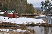
Mill Pond, where Shawneehaw Creek and the Elk River merge (2009-12-26)
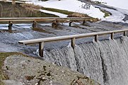
Unique bridge that fords Shawneehaw Creek (2009-12-26)

End NC 184 in 4 miles sign (2001-03-18)

See also[]
- Beech Mountain (North Carolina)
- Elizabethton, Tennessee
- Elk River (North Carolina)
- Roan Mountain, Tennessee
- Shawneehaw Creek
- Sugar Mountain (North Carolina)
- Watauga River
References[]
- ^ "2019 U.S. Gazetteer Files". United States Census Bureau. Retrieved July 27, 2020.
- ^ Jump up to: a b "U.S. Census website". United States Census Bureau. Retrieved 2008-01-31.
- ^ "US Board on Geographic Names". United States Geological Survey. 2007-10-25. Retrieved 2008-01-31.
- ^ Jump up to: a b "Population and Housing Unit Estimates". United States Census Bureau. May 24, 2020. Retrieved May 27, 2020.
- ^ Jump up to: a b "Geographic Identifiers: 2010 Demographic Profile Data (G001): Banner Elk town, North Carolina". U.S. Census Bureau, American Factfinder. Archived from the original on February 12, 2020. Retrieved July 3, 2013.
- ^ Heritage, 1976
- ^ "National Register Information System". National Register of Historic Places. National Park Service. July 9, 2010.
- ^ "National Register of Historic Places Listings". Weekly List of Actions Taken on Properties: 4/29/13 through 5/03/13. National Park Service. 2013-05-10.
- ^ "Census of Population and Housing". Census.gov. Retrieved June 4, 2015.
- ^ "US Gazetteer files: 2010, 2000, and 1990". United States Census Bureau. 2011-02-12. Retrieved 2011-04-23.
- ^ "NowData – NOAA Online Weather Data". National Oceanic and Atmospheric Administration. Retrieved May 12, 2021.
- ^ "Station: Banner Elk, NC". U.S. Climate Normals 2020: U.S. Monthly Climate Normals (1991-2020). National Oceanic and Atmospheric Administration. Retrieved May 12, 2021.
- ^ "Woolly Worm Festival". Woolly Worm Festival. Retrieved September 4, 2016.
External links[]
| show Municipalities and communities of Avery County, North Carolina, United States |
|---|

| show Authority control |
|---|
- Towns in North Carolina
- Towns in Avery County, North Carolina
- Populated places established in 1848