Banteay Meanchey Province
Banteay Meanchey
បន្ទាយមានជ័យ | |
|---|---|
| Banteay Meanchey Province ខេត្តបន្ទាយមានជ័យ | |
 Seal | |
 Map of Cambodia highlighting Banteay Meanchey | |
| Coordinates: 13°45′N 103°00′E / 13.750°N 103.000°ECoordinates: 13°45′N 103°00′E / 13.750°N 103.000°E | |
| Country | |
| Provincial status | 1993 |
| Capital | Serei Saophoan |
| Government | |
| • Governor | Um Reatrey (CPP) |
| Area | |
| • Total | 6,679 km2 (2,579 sq mi) |
| Area rank | 12th |
| Population (2019 census)[1] | |
| • Total | |
| • Rank | 9th |
| • Density | 129/km2 (330/sq mi) |
| • Density rank | 9th |
| Time zone | UTC+7 (ICT) |
| Dialing code | |
| ISO 3166 code | KH-1 |

Banteay Meanchey lit. "Fortress of Victory" (Khmer: បន្ទាយមានជ័យ, Bontiay Mianchey [ɓɑntiəj miəncɨj]) is a province of Cambodia located in the far northwest. It borders the provinces of Oddar Meanchey and Siem Reap to the east, Battambang to the south, and shares an international border with Thailand to the west. Its capital and largest city is Serei Saophoan.
Banteay Meanchey is the 13th largest province in Cambodia. With a population of 678,033, it ranks as the tenth most populous in the nation. The town of Poipet in the western part of the province is an international border crossing into Thailand. Banteay Meanchey is one of the nine provinces that are part of the Tonle Sap Biosphere Reserve.[2]
Etymology[]
Banteay Meanchey means "fortress of victory" in Khmer. The word -chey (ជ័យ) is derived from the Sanskrit word jaya (जय) meaning "victory" with mean- (មាន) means ''to have'', so the combination of both literally mean ''Has the Victory'' and banteay (បន្ទាយ) is a Khmer word meaning "fortress" or "castle".[3]
History[]

The area was part of the extensive Khmer Empire. Its most notable remains is the Banteay Chhmar temple in the north of the province, built in 12th century towards the 13th century. Other lesser known temples are the Banteay Neang and temples.[citation needed]
In the 1795 Siam took control over Western Cambodia, and made the area into Siamese province of Inner Cambodia with the administration capital in Phra Tabong (Battambang). This province lasted until 1907 when Siam traded Inner Cambodia for the return of Trat and Dan Sai. In the same year, King Sisowath decided to split the return Inner Cambodian Province into Battambang Province (which included Sisophon) and Siem Reap Province. When Thailand re annexed western Cambodia 1941, Sisophon was split off Battambang Province and was an administration capital of Phibunsongkram Province which lasted until 1946 when the whole region was return to the French control.[citation needed]
In 1988 the province Banteay Meanchey was split off from Battambang, originally consisting of the five districts Mongkol Borei, Thmar Puok, Serei Saophoan, Preah Net Preah and Phnom Srok.[4]
During the Cambodian Civil Wars of the 1970s and 1980s Banteay Meanchey Province was on the frontlines of much of fighting and as a result it is one of the three most heavily mined provinces in Cambodia along with Pailin and Battambang.[5]
Geography[]

Banteay Meanchey is mostly covered by extensive lowlands, with a few uplands to the north and east. The main rivers are the Mongkol Borei and the Sisophon Rivers. The province is bordered with Battambang to the south, Siem Reap to the East, Odar Meanchey to the North and Thailand to the West and North.
Economy[]
Poipet International Border Checkpoint[]
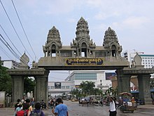
Banteay Meanchey has one of Cambodia's busiest checkpoints, Poipet International Border Checkpoint, for both people and goods. The checkpoint oversees approximately 2,000 tourists (50,000 tourists or 14% of nation's tourists annually in 2015) and 300 trucks carrying goods every day. In response to the increase of trade between Cambodia and Thailand, a new border checkpoint, Stueng Bot which is only 7 km from Poipet Checkpoint, is being constructed and slated to be completed by 2018. The new checkpoint will focus on trade while leaving Poipet Checkpoint for tourists.
Special Economic Zone (SEZ) and Industry[]
O'Neang Special Economic Zone was officially approved in 2006. In 2014, the zone hosted 5 factories includings CAMPAC Co. Ltd, a Thai company which produces package for jewellery, Hi-Tech Apparel (Cambodia) Co., Ltd., ML Intermate Apparel (Cambodia) Co., Ltd., SIMMER Inter Co., Ltd., and Wireform Precision Parts Co., Ltd. O'Neang employed 1,200 workers.[6] In recent years, Japanese and Cambodian investors jointly established a new Special Economic Zone, Sanco. The 66.5 hectare zone has already attracted NHK Spring, a Japanese car-seat manufacturer and Toyota supplier.[7] In March 2015, Toyota Tsusho Corporation (Toyota Tsusho) announced that it will establish Techno Park Poipet Pvt. Co., Ltd. to optimize its regional supply chains. The park will provide subcontracted auto part service and plans to service 10 or more companies by 2020.[8] Thanks to its cheap labour cost, cheaper and stable electricity supply from Thailand ( $0.16 per kilowatt), its proximity to Bangkok and favorable investment policy, Poipet is seen as a future industrial city of the Northwestern part of Cambodia.
Transportation[]
Banteay Meanchey sits on a strategic cross point that directs to Thailand, Siem Reap (Angkor Wat) and Battambang (gateway to Phnom Penh and Vietnam). As of 2018, infrastructure such as national roads, provincial roads and railway have been improved significantly. The historical re-operation of Royal Railway that links Thailand to Phnom Penh and Cambodia's seaport city started in April 2018. In this first phase, people can travel by train from Poi Pet to Sereisophorn and Battambang. Links from Battambang to Pursat, Kampong Chhnang and Phnom Penh will soon be completed. The national road number 5 is being upgraded to meet international standard. The project is funded by Japanese government in a broader plan to connect Thailand, Cambodia, and Vietnam.

Agriculture[]
Agriculture, particularly rice paddy, plays very important role in the province's economy.
Administration[]
The province is subdivided into 7 districts and 2 municipalities, which are further subdivided in 65 communes (khum) and 654 villages (phum).[9][10]
| ISO Code | District | Khmer | Population (2019)[11] |
|---|---|---|---|
| 01-02 | Mongkol Borey | ស្រុកមង្គលបូរី | 187,286 |
| 01-03 | Phnom Srok | ស្រុកភ្នំស្រុក | 65,945 |
| 01-04 | Preah Netr Preah | ស្រុកព្រះនេត្រព្រះ | 124,902 |
| 01-05 | Ou Chrov | ស្រុកអូរជ្រៅ | 63,413 |
| 01-06 | Serei Saophoan Municipality | ក្រុងសិរីសោភ័ណ | 99,019 |
| 01-07 | Thmar Puok | ស្រុកថ្មពួក | 76,926 |
| 01-08 | Svay Chek | ស្រុកស្វាយចេក | 81,106 |
| 01-09 | Malai | ស្រុកម៉ាឡៃ | 55,721 |
| 01-10 | Poipet Municipality | ក្រុងប៉ោយប៉ែត | 98,934 |
Attractions[]
Banteay Chhmar[]
Prasat Banteay Chhmar (Khmer: ប្រាសាទបន្ទាយឆ្មារ) is one of the masterpieces of the great king Jayavarman VII built between the 12th-13th century. Despite its magnificent architecture, the temples are lesser known to tourists and the world. Unlike other Angkorean temples, Banteay Chhmar is not well-conserved. The damages caused by war, looters and nature are very apparent. The temple is being on Cambodia's tentative list for UNESCO's world heritage in order to increase conservation and awareness.
|
Banteay Chhmar facetower |
 Moat, looking east |
 Causeway and moat around the temple |
 Bas-relief depicting Khmer's War against Champa |
References[]
- ^ "General Population Census of the Kingdom of Cambodia 2019 – Final Results" (PDF). National Institute of Statistics. Ministry of Planning. 26 January 2021. Retrieved 3 February 2021.
- ^ "Archived copy". Archived from the original on 2008-09-05. Retrieved 2018-11-02.CS1 maint: archived copy as title (link)
- ^ Headley, Robert K; Chhor, Kylin; Lim, Lam Kheng; Lim, Hak; Chun, Chen (1977). Cambodian-English Dictionary. Washington, D.C.: The Catholic University of America Press Bureau of Special Research in Modern Languages. ISBN 0813205093.
- ^ "Background of Battambang In the past and the present". Battambang town. Archived from the original on 2012-02-20. Retrieved 2007-07-12.
- ^ Flooding unearths Cambodia’s landmines, IRIN, PHNOM PENH, 21 October 2013 (IRIN), http://www.irinnews.org/report/98976/flooding-unearths-cambodia-s-landmines
- ^ "POSEZ" (PDF).
- ^ "Japanese investment rises as special zones gain traction".
- ^ "Toyota Tsusho to Establish First Japanese Techno-Park in Poipet, Cambodia Supporting Japanese manufacturing at key point along Southern Economic Corridor".
- ^ Royal Government of Cambodia Archived 2008-12-24 at the Wayback Machine
- ^ "Index Map 1-2. Provinces and Districts in Cambodia" (PDF). National Institute of Statistics, Ministry of Planning (Cambodia). 2013-12-31.
- ^ http://nis.gov.kh/nis/Census2019/Final%20General%20Population%20Census%202019-English.pdf
External links[]
- Banteay Meanchey at Royal Government of Cambodia website
- Banteay Meanchey at Ministry of Commerce website
| show Places adjacent to Banteay Meanchey Province |
|---|

- Banteay Meanchey Province
- Provinces of Cambodia