Serei Saophoan (city)
Serei Saophoan
សិរីសោភ័ណ Sĕri Saôphoăn | |
|---|---|
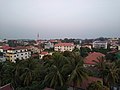
 Small lake in Serei Saophoan Municipality | |
 Serei Saophoan Location of Serei Saophoan, Cambodia | |
| Coordinates: 13°35′N 102°59′E / 13.583°N 102.983°E | |
| Country | |
| Province | Banteay Meanchey |
| Municipality | Serei Saophoan |
| Government | |
| • Mayor | Hil Raya |
| Elevation | 15 m (49 ft) |
| Population (2019)[1] | |
| • Total | 99,019 |
| • Rank | 4th |
| Time zone | UTC+7 (ICT) |

Serei Saophoan (Khmer: សិរីសោភ័ណ, Sĕri Saôphoăn [serəj saopʰɔən]; lit. 'Beautiful Freedom') is the capital and largest city of the Banteay Meanchey Province and the fourth most populous city in Cambodia. The city separates Cambodia's National Highway 5 and National Highway 6. Its administrative name is "Serei Sophon" as used by the government. The more commonly used name Sisophon is derived from the Thai pronunciation Si Sophon when it was under the Thai rule. Another nickname "Svay" is used mainly by truck drivers, train drivers and workers transporting goods. The origin of the word "Svay" is unknown. Its population is 61,482 in the 1998 census, changing little to 61,631 in the 2008 census having been overtaken by Poipet in size.[2]
About forty minutes from Sisophon there is a Khmer temple ruin called Banteay Chmar.

See also[]
References[]
- ^ "General Population Census of the Kingdom of Cambodia 2019 – Final Results" (PDF). National Institute of Statistics. Ministry of Planning. 26 January 2021. Retrieved 4 February 2021.
- ^ http://www.citypopulation.de/Cambodia.html Citypopulation.de Cambodia
External links[]
 Sisophon travel guide from Wikivoyage


Coordinates: 13°35′N 102°59′E / 13.583°N 102.983°E
This Cambodian location article is a stub. You can help Wikipedia by . |
- Provincial capitals in Cambodia
- Cities in Cambodia
- Serei Saophoan District
- Populated places in Banteay Meanchey province
- Cambodia geography stubs