Barnes Glacier
From Wikipedia, the free encyclopedia
Glacier in Antarctica
| Barnes Glacier | |
|---|---|
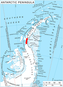 Location of Hemimont Plateau on the Antarctic Peninsula | |
 Location of Barnes Glacier in Antarctica | |
| Location | Graham Land |
| Coordinates |  67°32′S 66°25′W / 67.533°S 66.417°W / -67.533; -66.417 67°32′S 66°25′W / 67.533°S 66.417°W / -67.533; -66.417 |
| Thickness | unknown |
| Highest elevation | 400 m (1,312 ft) |
| Terminus | Blind Bay |
| Status | unknown |
Barnes Glacier (67°32′S 66°25′W / 67.533°S 66.417°W / -67.533; -66.417Coordinates: WikiMiniAtlas67°32′S 66°25′W / 67.533°S 66.417°W / -67.533; -66.417) is a glacier on the west side of Hemimont Plateau flowing west into Blind Bay on the west coast of Graham Land. It was named by the UK Antarctic Place-Names Committee in 1958 for , Canadian physicist and pioneer of ice engineering.
See also[]
- List of glaciers in the Antarctic
- Glaciology
References[]
 This article incorporates public domain material from the United States Geological Survey document: "Barnes Glacier". (content from the Geographic Names Information System)
Portal: Geography
Glaciers in the Antarctic | |
|---|---|
|
Glaciers of Graham Land | |
|---|---|
| Antarctic Peninsula |
|
| Adelaide Island |
|
| James Ross Island |
|
| Palmer Archipelago |
|
| Trinity Peninsula |
|
This article about a glacier in Loubet Coast is a stub. You can help Wikipedia by . |
- v
- t
Retrieved from ""
Categories:
- Glaciers of Loubet Coast
- Graham Land glacier stubs
- Loubet Coast geography stubs
Hidden categories:
- Articles with short description
- Short description matches Wikidata
- Coordinates on Wikidata
- Wikipedia articles incorporating text from the USGS Geographic Names Information System
- All stub articles