Barrio Libre
Barrio Libre | |
U.S. National Register of Historic Places | |
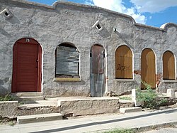 Building in Barrio Libre in 2012 | |
| Location | Roughly bounded by 14th, 19th, Stone and Osborne Sts., Tucson, Arizona |
|---|---|
| Area | 77 acres (31 ha) |
| Built | 1885 |
| Architectural style | Bungalow/craftsman, Queen Anne, Sonoran Adobe |
| NRHP reference No. | 78000565[1] |
| Added to NRHP | October 18, 1978 |
Barrio Libre is a neighborhood in Tucson, Arizona notable for its existence as a relatively unchanged 19th-century Hispanic neighborhood of close-packed row houses. Houses in the barrio are typically adobe with very plain detailing, reflecting the area's history as a district of townhouses for Mexican ranching families. The district includes more than 200 contributing structures, with relatively few non-conforming buildings. The district is bounded by 14th and 18th streets to the north and south, and by Stone and Osborne to the east and west. Meyer Avenue runs through the center of the barrio.[2]
The district was listed on the National Register of Historic Places on October 18, 1978.[1]
References[]
- ^ a b "National Register Information System". National Register of Historic Places. National Park Service. July 9, 2010.
- ^ Fisher, Tim (September 26, 1977). "National Register of Historic Places Inventory – Nomination Form: Barrio Libre". National Park Service. Retrieved 27 June 2015.
External links[]
- Barrio Libre at the National Park Service
- Tucson's Barrio Libre online chapter from Barrio Historico Tucson, University of Arizona
- Historic American Buildings Survey (HABS) No. AZ-73, "Barrio Libre, West Kennedy & West Seventeenth Streets, Meyer & Convent Avenues, Tucson, Pima County, AZ", 13 photos, 28 measured drawings, 19 data pages, 2 photo caption pages, with additional surveys of individual houses in the district [1], [2], [3], [4] and many others
 | |||

Categories:
- Neighborhoods in Tucson, Arizona
- Historic districts on the National Register of Historic Places in Arizona
- National Register of Historic Places in Tucson, Arizona
- Buildings and structures completed in 1885
- Historic American Buildings Survey in Arizona