Bech
Bech
Bech | |
|---|---|
Commune | |
 | |
 Coat of arms | |
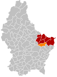 Map of Luxembourg with Bech highlighted in orange, and the canton in dark red | |
| Coordinates: 49°45′10″N 6°21′40″E / 49.7528°N 6.3611°ECoordinates: 49°45′10″N 6°21′40″E / 49.7528°N 6.3611°E | |
| Country | |
| Canton | Echternach |
| Government | |
| • Mayor | |
| Area | |
| • Total | 23.31 km2 (9.00 sq mi) |
| Area rank | 39th of 102 |
| Highest elevation | 408 m (1,339 ft) |
| • Rank | 43rd of 102 |
| Lowest elevation | 261 m (856 ft) |
| • Rank | 64th of 102 |
| Population (2018) | |
| • Total | 1,265 |
| • Rank | 93rd of 102 |
| • Density | 54/km2 (140/sq mi) |
| • Density rank | 87th of 102 |
| Time zone | UTC+1 (CET) |
| • Summer (DST) | UTC+2 (CEST) |
| LU0001002 | |
| Website | bech.lu |

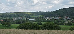
Bech is a commune and small town in eastern Luxembourg. It is part of the canton of Echternach, which is part of the district of Grevenmacher.
As of 2005, the town of Bech, which lies in the east of the commune, has a population of 368. Villages within the commune include Altrier and Rippig.

Western side of the old railway tunnel built in 1901, now converted to a bicycle route
External links[]
 Media related to Bech at Wikimedia Commons
| show Places adjacent to Bech |
|---|

| Authority control |
|---|
This article related to the geography of Echternach canton is a stub. You can help Wikipedia by . |
Categories:
- Towns in Luxembourg
- Communes in Echternach (canton)
- Luxembourg geography stubs