Waldbillig
This article does not cite any sources. (December 2009) |
Waldbillig
Waldbëlleg, Bëlleg | |
|---|---|
Commune | |
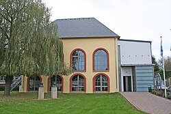 Town hall | |
 Coat of arms | |
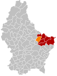 Map of Luxembourg with Waldbillig highlighted in orange, and the canton in dark red | |
| Coordinates: 49°47′45″N 6°17′10″E / 49.7958°N 6.2861°ECoordinates: 49°47′45″N 6°17′10″E / 49.7958°N 6.2861°E | |
| Country | |
| Canton | Echternach |
| Area | |
| • Total | 23.28 km2 (8.99 sq mi) |
| Area rank | 40th of 102 |
| Highest elevation | 387 m (1,270 ft) |
| • Rank | 63rd of 102 |
| Lowest elevation | 186 m (610 ft) |
| • Rank | 18th of 102 |
| Population (2018) | |
| • Total | 1,783 |
| • Rank | 82nd of 102 |
| • Density | 77/km2 (200/sq mi) |
| • Density rank | 78th of 102 |
| Time zone | UTC+1 (CET) |
| • Summer (DST) | UTC+2 (CEST) |
| LU0001008 | |
| Website | waldbillig.lu |

Waldbillig (Luxembourgish: Waldbëlleg or (locally) Bëlleg [ˈbələɕ]) is a commune and small town in the canton of Echternach, Luxembourg.
As of 2001, the town of Waldbillig, which lies in the centre of the commune, has a population of 394. Other towns within the commune include Christnach, Haller, and Mullerthal.
References[]
External links[]
 Media related to Waldbillig at Wikimedia Commons
| show Places adjacent to Waldbillig |
|---|

| show Authority control |
|---|
This article related to the geography of Echternach canton is a stub. You can help Wikipedia by . |
Categories:
- Waldbillig
- Communes in Echternach (canton)
- Towns in Luxembourg
- Luxembourg geography stubs