Vallée de l'Ernz
Vallée de l'Ernz
Ärenzdall | |
|---|---|
Commune | |
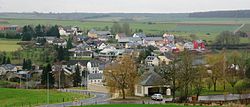 Ermsdorf | |
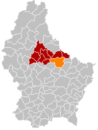 Map of Luxembourg with Vallée de l'Ernz highlighted in orange, and the canton in dark red | |
| Coordinates: 49°49′N 6°13′E / 49.82°N 6.22°ECoordinates: 49°49′N 6°13′E / 49.82°N 6.22°E | |
| Country | |
| Canton | Diekirch |
| Area | |
| • Total | 39.73 km2 (15.34 sq mi) |
| Area rank | 13th of 102 |
| Highest elevation | 420 m (1,380 ft) |
| • Rank | 36th of 102 |
| Lowest elevation | 213 m (699 ft) |
| • Rank | 31st of 102 |
| Population (2018) | |
| • Total | 2,594 |
| • Rank | 57th of 102 |
| • Density | 65/km2 (170/sq mi) |
| • Density rank | 80th of 102 |
| Time zone | UTC+1 (CET) |
| • Summer (DST) | UTC+2 (CEST) |
| LU0000610 | |
| Website | www |

Vallée de l'Ernz (Luxembourgish: Ärenzdall) is a commune in northern Luxembourg, in the canton of Diekirch.
The commune of Vallée de l'Ernz was formed on 1 January 2012 from the former communes of Ermsdorf and Medernach. The law creating the Vallée de l'Ernz was passed on 24 May 2011.[1] It has an area of 39.73 km2.
Populated places[]
The commune consists of the following villages:
|
References[]
- ^ "Mémorial A, 2011, No. 110" (PDF) (in French). Service central de législation. Retrieved 2012-01-02.
External links[]
 Media related to Vallée de l'Ernz at Wikimedia Commons
| show Places adjacent to Vallée de l'Ernz |
|---|

This article related to the geography of Diekirch canton is a stub. You can help Wikipedia by . |
Categories:
- Communes in Diekirch (canton)
- Luxembourg geography stubs