Reisdorf
This article does not cite any sources. (December 2009) |
Reisdorf
Reisduerf | |
|---|---|
Commune | |
 Reisdorf seen from the north | |
 Coat of arms | |
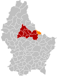 Map of Luxembourg with Reisdorf highlighted in orange, and the canton in dark red | |
| Coordinates: 49°52′00″N 6°16′00″E / 49.8667°N 6.2667°ECoordinates: 49°52′00″N 6°16′00″E / 49.8667°N 6.2667°E | |
| Country | |
| Canton | Diekirch |
| Area | |
| • Total | 14.84 km2 (5.73 sq mi) |
| Area rank | 80th of 102 |
| Highest elevation | 406 m (1,332 ft) |
| • Rank | 44th of 102 |
| Lowest elevation | 175 m (574 ft) |
| • Rank | 15th of 102 |
| Population (2018) | |
| • Total | 1,206 |
| • Rank | 96th of 102 |
| • Density | 81/km2 (210/sq mi) |
| • Density rank | 70th of 102 |
| Time zone | UTC+1 (CET) |
| • Summer (DST) | UTC+2 (CEST) |
| LU0000608 | |
| Website | reisdorf.lu |

Reisdorf (Luxembourgish: Reisduerf) is a commune and small town in eastern Luxembourg, on the river Sauer. It is part of the canton of Diekirch.
In 2020, Reisdorf, which lies in the centre of the commune, had a population of 1276. Other towns within the commune include Bigelbach, Hoesdorf, and Wallendorf-Pont.

Reisdorf town hall
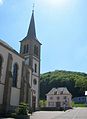
Reisdorf town hall and church

Wayside cross at the N10, just outside the town

Panorama between Reisdorf and Beaufort


References[]
External links[]
 Media related to Reisdorf (Luxembourg) at Wikimedia Commons
| show Places adjacent to Reisdorf |
|---|

| Authority control |
|
|---|
This article related to the geography of Diekirch canton is a stub. You can help Wikipedia by . |
Categories:
- Communes in Diekirch (canton)
- Towns in Luxembourg
- Luxembourg geography stubs