Beckerich
This article does not cite any sources. (December 2015) |
Beckerich
Biekerech | |
|---|---|
Commune | |
 | |
 Coat of arms | |
 Map of Luxembourg with Beckerich highlighted in orange, and the canton in dark red | |
| Coordinates: 49°44′00″N 5°53′00″E / 49.7333°N 5.8833°ECoordinates: 49°44′00″N 5°53′00″E / 49.7333°N 5.8833°E | |
| Country | |
| Canton | Redange |
| Area | |
| • Total | 28.41 km2 (10.97 sq mi) |
| Area rank | 28th of 102 |
| Highest elevation | 400 m (1,300 ft) |
| • Rank | 50th of 102 |
| Lowest elevation | 265 m (869 ft) |
| • Rank | 68th of 102 |
| Population (2018) | |
| • Total | 2,518 |
| • Rank | 60th of 102 |
| • Density | 89/km2 (230/sq mi) |
| • Density rank | 69th of 102 |
| Time zone | UTC+1 (CET) |
| • Summer (DST) | UTC+2 (CEST) |
| LU0000701 | |
| Website | beckerich.lu |

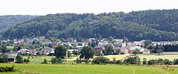
Beckerich (Luxembourgish: Biekerech) is a commune and small town in western Luxembourg, in the canton of Redange. The town was founded in 1678 during the Fall of Stuarts. It lies close to the border with Belgium.
As of 2005, the town of Beckerich, which lies in the centre of the commune, has a population of 635.
Beckerich has a drinking water production plant, which supplies Lidl Stores with water internationally. It supplies about 85% of its energy needs, exclusive of transportation, from alternative energy sources, primarily manure.
Populated places[]
The commune consists of the following villages:
|
|
|
References[]
External links[]
 Media related to Beckerich at Wikimedia Commons
| show Places adjacent to Beckerich |
|---|

| Authority control |
|
|---|
This article related to the geography of Redange canton is a stub. You can help Wikipedia by . |
Categories:
- Beckerich
- Communes in Redange (canton)
- Towns in Luxembourg
- Luxembourg geography stubs