Redange (canton)
This article needs additional citations for verification. (December 2009) |
Redange
Redingen Réiden | |
|---|---|
 | |
| Coordinates: 49°48′N 5°48′E / 49.800°N 5.800°ECoordinates: 49°48′N 5°48′E / 49.800°N 5.800°E | |
| Country | Luxembourg |
| Legislative constituency | Nord |
| LU00003 | |
| Capital | Redange-sur-Attert |
| Communes (cities in bold) | Beckerich Ell Grosbous Préizerdaul Rambrouch Redange Saeul Useldange Vichten Wahl |
| Area | |
| • Total | 267.49 km2 (103.28 sq mi) |
| Area rank | 2nd of 12 |
| Highest elevation (2nd of 12) | 554 m (1,818 ft) |
| Lowest elevation (10th of 12) | 232 m (761 ft) |
| Population (2005) | |
| • Total | 14,499 |
| • Rank | 9th of 12 |
| • Density | 54/km2 (140/sq mi) |
| • Density rank | 9th of 12 |

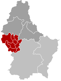
Redange is a canton in the west of Luxembourg. The capital is Redange, otherwise known as Redange-sur-Attert.
Administrative divisions[]
Redange Canton consists of the following ten communes:
Mergers[]
- On 25 July 1846 the former commune of Oberpallen was absorbed into the commune of Beckerich.
- On 1 January 1979 the former communes of Arsdorf, Bigonville, Folschette and Perlé (all from Redange Canton) were merged to create the commune of Rambrouch. The law creating Rambrouch was passed on 27 July 1978.[1]
References[]
- ^ "Mémorial A, 1978, No. 46" (PDF) (in French). Service central de législation. Retrieved 2006-08-11.
| hide | |
|---|---|
See also: Districts (former subdivision) - Electoral constituencies |
This article related to the geography of Redange canton is a stub. You can help Wikipedia by . |
Categories:
- Redange (canton)
- Cantons of Luxembourg
- Luxembourg geography stubs