Beheira Governorate
Beheira Governorate | |
|---|---|
 Flag  | |
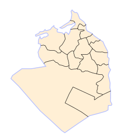 Beheira Governorate subdivisions | |
 Beheira Governorate on the map of Egypt | |
| Coordinates: 30°37′N 30°26′E / 30.61°N 30.43°ECoordinates: 30°37′N 30°26′E / 30.61°N 30.43°E | |
| Country | |
| Seat | Damanhur (capital) |
| Government | |
| • Governor | Nadia Ahmed Abdou[1] |
| Area | |
| • Total | 9,826 km2 (3,794 sq mi) |
| Population (January 2018) | |
| • Total | 6,277,000[3] |
| Time zone | UTC+2 (EET) |
| HDI (2017) | 0.687[4] medium |
| Website | behira |

Beheira Governorate (Arabic: محافظة البحيرة Moḥafzet el Beḥēra, IPA: [moˈħɑfzet elbeˈħeːɾæ], "the governorate of the Lake") is a coastal governorate in Egypt. Located in the northern part of the country in the Nile Delta, its capital is Damanhur.
Overview[]
Beheira Governorate enjoys an important strategical place, west of the Rosetta branch of the Nile. It comprises four important highways, namely the Cairo-Alexandria desert road, the Cairo agricultural road, the international road and the circular road. Beheira Governorate is also home to a number of the most important Coptic monasteries in Wadi El Natrun (Scetes).[2][5]
Beheira consists of 13 centers and 14 cities, and contains important industries such as cotton, chemicals, carpets, electricity and fishing.
The governorate has a noteworthy number of archaeological sites, inclusively at Abu El Matamir, Abu Hummus, Damanhour, Rashid (Rosetta) and Kafr El Dawwar.[6] Coins, lamps, animal bones and pottery from Roman and Byzantine eras are some of the archaeological finds discovered at Kom El Giza and Kom El Hamam in Beheira.[7]
In 2017, Egyptian President Abdel Fattah al-Sissi appointed the first female governor in the country's history, Nadia Ahmed Abdou, for Beheira's Governorate.[8]
The rate of poverty is more than 60% in this governorate but recently some social safety networks have been provided in the form of financial assistance and job opportunities. The funding has been coordinated by the country's Ministry of Finance and with assistance from international organizations.[9]
Municipal divisions[]
The governorate is divided into the following municipal divisions for administrative purposes, with a total estimated population as of July 2017 of 6,200,137. In some instances there is a markaz and a kism with the same name.[10][11]
| Anglicized name | Native name | Arabic transliteration | Population (July 2017 Est.) |
Type |
|---|---|---|---|---|
| Abu El Matamir | مركز ابو المطامير | Abū al-Maṭāmīr | 555,471 | Markaz |
| Abu Hummus | مركز ابوحمص | Abū Ḥummuṣ | 535,823 | Markaz |
| El Delengat | مركز الدلنجات | Ad-Dilinjāt | 400,570 | Markaz |
| Mahmoudiyah | مركز المحمودية | Al-Maḥmūdiyah | 281,455 | Markaz |
| Rahmaniya | مركز الرحمانية | Ar-Raḥmāniyah | 158,819 | Markaz |
| Badr | مركز بدر | Badr | 208,542 | Markaz |
| Damanhour | قسم دمنهور | Damanhūr | 262,505 | Kism (fully urban) |
| Damanhour | مركز دمنهور | Damanhūr | 548,390 | Markaz |
| West Nubariyah | قسم غرب النوبارية | Gharb an-Nūbāriyah | 118,786 | Kism (urban and rural parts) |
| Hosh Essa | مركز حوش عيسى | Ḥawsh 'Īsā | 306,231 | Markaz |
| Edku | مركز إدكو | Idkū | 216,892 | Markaz |
| Itay El Barud | مركز إيتاى البارود | Ityāy al-Bārūd | 476,197 | Markaz |
| Kafr El Dawwar | قسم كفر الدوار | Kafr ad-Dawwār | 304,258 | Kism (urban and rural parts) |
| Kafr El Dawwar | مركز كفر الدوار | Kafr ad-Dawwār | 701,199 | Markaz |
| Kom Hamada | مركز كوم حمادة | Kawm Ḥamādah | 496,752 | Markaz |
| Rosetta | مركز رشيد | Rashīd | 271,947 | Markaz |
| Shubrakhit | مركز شبراخيت | Shubrākhīt | 277,231 | Markaz |
| Natrn Valley | مركز وادى النطرون | Wadi an-Natrun | 79,069 | Markaz |
Population[]
According to population estimates, in 2015 the majority of residents in the governorate lived in rural areas, with an urbanization rate of only 19.5%. Out of an estimated 5,804,262 people residing in the governorate, 4,674,346 people lived in rural areas as opposed to only 1,129,916 in urban areas.[12]
Cities and towns[]
- Abu Hummus
- Abu El Matamir
- Damanhur
- Edku
- El Delengat
- El Mahmoudiyah
- El Rahmaniya
- Itay El Barud
- Kafr El Dawwar
- Rosetta
- Wadi El Natrun
Notable people[]
- Karim Hafez, footballer
- Rehab Elgamal, Actress
- Ahmed Elgamal, Music Composer
Industrial zones[]
According to the Egyptian Governing Authority for Investment and Free Zones (GAFI), in affiliation with the Ministry of Investment (MOI), the following industrial zones are located in this governorate:[13][2]
- Natron Valley
- Boseili Desert
- (New urban community industrial zone) Nubaria
- Edco
Projects and programs[]
In 1981, the Basic Village Service Program (BVS), under the auspices of USAID, had several water, road, and other projects, going on in several markazes in Beheira Governorate.[14]
In 2018 the governorate council discussed a campaign of mosquito control and animal control to avert the spread of preventable diseases.[15]
References[]
- ^ "رسمياً.. المحافظون الجدد ونوابهم يؤدون اليمين الدستورية أمام الرئيس". Almasry Alyoum (in Arabic). 30 August 2018. Archived from the original on 2018-08-31. Retrieved 2018-08-31.
- ^ Jump up to: a b c "El-Beheira Governorate". sis.gov.eg. 24 May 2016.
- ^ "Population Estimates By Governorate ( Urban /Rural ) 1/1/2018". www.capmas.gov.eg. Archived from the original on 2018-11-02. Retrieved 10 October 2018.
- ^ "Sub-national HDI - Area Database - Global Data Lab". hdi.globaldatalab.org. Retrieved 2018-09-13.
- ^ "Al-Buḥayrah GOVERNORATE, EGYPT". britannica.
- ^ Wilson, Penelope Grigoropoulos, Dimitris (2009). West Delta Regional Survey, Beheira and Kafr el-Sheikh provinces. Excavation memoir. London : Egypt Exploration Society. ISBN 9780856981944. OCLC 690191661.
- ^ Bergmann, Marianne; Heinzelmann, Michael. "Schedia Project at Kom El Giza / Kom El Haman" (PDF). archaeologie.uni-koeln.de. University of Goettingen/Germany at Schedia.
- ^ "Egypt's first-ever female governor marches to a different drummer". Al-Monitor. 2017-02-22. Archived from the original on 2017-02-23. Retrieved 2017-02-22.
- ^ "Social Solidarity Ministry to provide citizens with disabilities financial support". Egypt Independent. 25 July 2017. Retrieved 11 December 2018.
- ^ "Beheira Governorate Subdivisions". CityPopulation.de. Archived from the original on 2018-11-25. Retrieved 2018-11-24.
- ^ "Markazes of Egypt". statoids.com. Gwillim Law. Archived from the original on 2017-10-19. Retrieved 26 November 2018.
- ^ "Population Estimates By Sex & Governorate 1/1/2015" (PDF). CAPMAS. Archived (PDF) from the original on 2015-10-19. Retrieved 23 October 2016.
- ^ "Industrial Zones of Governorate". Ministry of Investment Egypt. Archived from the original on 2018-11-23. Retrieved 23 November 2018.
- ^ "Egypt: The Basic Village Services Program" (PDF). USAID. Archived (PDF) from the original on 2016-10-19. Retrieved 19 October 2016.
- ^ Qassam, Hamdi (19 November 2018). "Secretary General discusses stray dogs and mosquitoes in the lake". Al Masry Al Youm. Archived from the original on 2018-11-20. Retrieved 2018-11-20.
External links[]
| show Authority control |
|---|
- Beheira Governorate
- Governorates of Egypt