Monufia Governorate
This article may be expanded with text translated from the corresponding article in Arabic. (April 2019) Click [show] for important translation instructions.
|
Menoufia Governorate | |
|---|---|
 Flag  | |
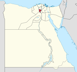 Monufia Governorate on the map of Egypt | |
| Coordinates: 30°31′N 30°59′E / 30.52°N 30.99°ECoordinates: 30°31′N 30°59′E / 30.52°N 30.99°E | |
| Country | |
| Seat | Shibin El Kom |
| Government | |
| • Governor | Ibrahim abo lamon[2] |
| Area | |
| • Total | 2,543.03 km2 (981.87 sq mi) |
| Population (January 2018) | |
| • Total | 4,366,000[1] |
| Time zone | UTC+2 (EET) |
| HDI (2017) | 0.718[3] high · 6th |
| Website | www |

Monufia Governorate (Arabic: محافظة المنوفية Muḥāfaẓah Al Monofeya IPA: [elmenoˈfejjæ, -monoˈ-]) is one of the governorates of Egypt. It is located in the northern part of the country in the Nile Delta, to the south of Gharbia Governorate and to the north of Cairo. The governorate is named after Menouf, an ancient city which was the capital of the governorate until 1826. The current governor is Said Mohammed Mohammed Abbas.[4]
Municipal divisions[]
The governorate is divided into municipal divisions, with a total estimated population as of July 2017 of 4,319,082. In some instances there is a markaz and a kism with the same name.[5][6]
| Anglicized name | Native name | Arabic transliteration | Population (July 2017 Est.) |
Type |
|---|---|---|---|---|
| El Bagour | مركز الباجور | Al-Bājūr | 401,925 | Markaz |
| Ashmoun | مركز أشمون | Ashmūn | 848,652 | Markaz |
| El Shohada | مركز الشهداء | Ash-Shuhadā' | 346,215 | Markaz |
| Birket el Sab | مركز بركة السبع | Birkat as-Sab' | 311,299 | Markaz |
| Sadat City | مركز و مدينة السادات | Madīnat as-Sādāt | 178,849 | Markaz |
| Menouf | قسم مدينة منوف | Minūf | 113,262 | Kism (fully urban) |
| Menouf | مركز منوف | Minūf | 441,765 | Markaz |
| Quweisna | مركز قويسنا | Quwaysinā | 496,137 | Markaz |
| Shibin el Kom | قسم شبين الكوم | Shibīn al-Kawm | 241,409 | Kism (fully urban) |
| Shibin el Kom | مركز شبين الكوم | Shibīn al-Kawm | 480,161 | Markaz |
| Sers El Lyan | قسم سرس الليانة | Sirs al-Layyānah | 70,431 | Kism (fully urban) |
| Tala | مركز تلا | Talā | 388,977 | Markaz |
Population[]
According to population estimates in 2015, the majority of residents in the governorate lived in rural areas, with an urbanization rate of only 20.6%. Out of an estimated 3,941,293 people residing in the governorate, 3,128,460 people lived in rural areas as opposed to only 812,833 in urban areas.[7]
Cities[]
The capital of the Monufia Governorate is the city of Shibin El Kom. The main cities of the governorate are Quesna, Tala, Bagour, Menouf, Ashmoun and Sers El Lyan. It is mainly an agricultural governorate.[8]
Industrial zones[]
According to the Egyptian Governing Authority for Investment and Free Zones (GAFI), in affiliation with the Ministry of Investment (MOI), the following industrial zones are located in this governorate:[9]
- Mubarak Industrial Zone and its expansion
- Industrial Zones In kafr Dawod
- (New urban community industrial zone) El Sadat
- Industrial zone El lawy stud ran by El doc ramy
History[]
In 1826, Mohammed Ali transferred the capital of Monufia from Menouf to Shibin El Kom as the latter fell exactly in the center of the governorate. Other than Shibin El Kom, the governorate had four other administrative divisions which are Quesna, Tala, Menouf and Talawy. In 1942, El Shohada became a new administrative division and included parts from Shibin El Kom and Tala. In 1947, Bagour was created to encompass regions from Menouf, Talawy, Quesna and Shibin El Kom. In 1955, five villages were taken from Tala and redistributed to Tanta. In 1960, Berket El Sabe'e (Lake of the Lion) was established and consisted of former towns and villages of Tala, Quesna and Shibin El Kom. In 1975, Sers El Lyan became a city rather than a village after it was separated from Menouf. In 1991, Sadat City was annexed to Monufia, being its only region west of the Rosetta branch. In the final round of the 2012 Egyptian presidential election, Monufia had the highest voter turnout rate of all governorates (61.5%) as well as the most overwhelming support for candidate Ahmed Shafik (71.5%).
Agriculture[]
The governorate is famous for the production of crops like cotton, maize and wheat as well as vegetable crops such as potatoes and green beans of which a large part is exported. Agricultural land is irrigated with water from the Rosetta and Damietta branches of the Nile. Agriculture is generally the main activity of the population due to the fertile land in the Nile Delta.[10]
Notable residents[]
Monufia Governorate is particularly known for being the birthplace of two Egyptian presidents, Anwar Sadat (1918–1981), born in Mit Abu El Kom and Hosni Mubarak (1928-2020), born in .
Projects[]
In 1981, the Basic Village Service Program (BVS), under the auspices of USAID, had several water, road, and other projects, going on in several markazes in the Monufia Governorate.[11]
In 2018, the National Agricultural Animal Health Services (NAAHS) was formed by the Ministry of Agriculture in order to care for the rising number of infected horses and donkeys in the Shibin El-Kom area. This was sparked by the tragedy.
References[]
- ^ "Population Estimates By Governorate ( Urban /Rural ) 1/1/2018". capmas.gov.eg. Archived from the original on 2018-11-02. Retrieved 10 October 2018.
- ^ "رسمياً.. المحافظون الجدد ونوابهم يؤدون اليمين الدستورية أمام الرئيس". Almasry Alyoum (in Arabic). 30 August 2018. Archived from the original on 2018-08-31. Retrieved 2018-08-31.
- ^ "Sub-national HDI - Area Database - Global Data Lab". hdi.globaldatalab.org. Retrieved 2018-09-13.
- ^ "Governor's Bio". monofeya.gov. Archived from the original on 2018-04-16. Retrieved 2018-11-20.
- ^ "Monufia Governorates Subdivisions". CityPopulation.de. Archived from the original on 2018-11-25. Retrieved 2018-11-24.
- ^ "Markazes of Egypt". statoids.com. Gwillim Law. Archived from the original on 2017-10-19. Retrieved 26 November 2018.
- ^ "Population Estimates By Sex & Governorate 1/1/2015" (PDF). CAPMAS. Archived from the original (PDF) on 2015-10-19. Retrieved 23 October 2016.
- ^ "Cities". Monofeya Gov Egypt. Archived from the original on 2018-05-01. Retrieved 2018-11-20.
- ^ "Industrial Zones of Governorate". Ministry of Investment Egypt. Archived from the original on 2018-11-23. Retrieved 23 November 2018.
- ^ "Al-Minūfiyyah GOVERNORATE, EGYPT". britannica.
- ^ "Egypt: The Basic Village Services Program" (PDF). USAID. Archived (PDF) from the original on 2016-10-19. Retrieved 19 October 2016.
External links[]
| Urban | ||
|---|---|---|
| Lower Egypt | ||
| Upper Egypt | ||
| Frontier | ||
- Monufia Governorate
- Governorates of Egypt
- Nile Delta