Beinn Ghlas
| Beinn Ghlas | |
|---|---|
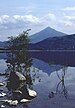
 Beinn Ghlas from the western slopes of Ben Lawers | |
| Highest point | |
| Elevation | 1,103 m (3,619 ft)[1] |
| Prominence | c. 105 m |
| Listing | Munro |
| Naming | |
| English translation | Grey-green mountain |
| Language of name | Gaelic |
| Pronunciation | Scottish Gaelic: [peɲ ˈɣl̪ˠas̪] |
| Geography | |
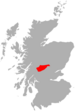
| Location | Perth and Kinross, Scotland |
| OS grid | NN625404 |
| Topo map | OS Landranger 51 |

Beinn Ghlas is a mountain in the Southern Highlands of Scotland. It lies on the north shore of Loch Tay and is part of the Ben Lawers Range. It lies on the popular path to Ben Lawers from the National Trust for Scotland car park, with the result that many walkers traverse the summit of Beinn Ghlas without realising it. The popularity of the path meant that it suffered from severe erosion, but it has been reconstructed in recent years.
The Gaelic name is translated as 'grey-green mountain', which refers to the colour of the mica-schist that makes up the bulk of the mountain and that falls as a scree on its south-western side. The path up the mountain leads past outcrops of this rock that also reveal large garnets.
As mentioned above, the usual route to the summit leaves from the car park, follows Edramucky Burn, and climbs to the south-western ridge of the mountain. The deep corrie of Coire Odhar (the dun-coloured corrie) lies to the north. Walkers who continue on to Ben Lawers can avoid the 100 metre re-ascent of Beinn Ghlas on their return by taking the path that runs west of the summit, down to Coire Odhar.
References[]
- ^ "walkhighlands Beinn Ghlas". walkhighlands.co.uk. 2013. Retrieved 20 October 2013.
Coordinates: 56°32′08″N 4°14′15″W / 56.53543°N 4.23743°W
This Perth and Kinross location article is a stub. You can help Wikipedia by . |
- Munros
- Mountains and hills of the Southern Highlands
- Mountains and hills of Perth and Kinross
- National Trust for Scotland properties
- One-thousanders of the British Isles
- Perth and Kinross geography stubs