Stuchd an Lochain
| Stuchd an Lochain | |
|---|---|
| Scottish Gaelic: Stùc an Lochain | |
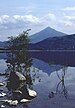
 Stuchd an Lochain from the ridge leading to Meall Odhair | |
| Highest point | |
| Elevation | 960 m (3,150 ft)[1] |
| Prominence | 482 m (1,581 ft) |
| Parent peak | Schiehallion |
| Listing | Munro, Marilyn |
| Naming | |
| English translation | Peak of the little loch |
| Language of name | Gaelic |
| Pronunciation | Scottish Gaelic: [ˈs̪t̪uːxk ə ˈl̪ˠɔxɛɲ] |
| Geography | |
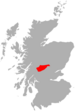
| Location | Stirling council area, Scotland |
| OS grid | NN483448 |
| Topo map | OS Landranger 51 |

Stuchd an Lochain (Scottish Gaelic: Stùc an Lochain) is a Munro situated in the Southern Highlands of Scotland. It lies at the western end of Glen Lyon and forms the southern side of . The summit sits above a large corrie that contains a small lochan. The primary route to the summit leaves from the eastern end of Loch an Daimh and climbs the ridge to the top of Sron Chona Choirein. From here the ridge turns roughly north for a short distance before turning north-west to the summit. Fit walkers can continue west for a circular walk around the loch taking in a Corbett, , and another Munro, Meall Buidhe.
References[]
- ^ "walkhighlands Stuchd an Lochain". walkhighlands.co.uk. 2013. Retrieved 26 October 2013.
Coordinates: 56°34′14″N 4°28′14″W / 56.57056°N 4.47067°W
This Stirling location article is a stub. You can help Wikipedia by . |
Categories:
- Munros
- Marilyns of Scotland
- Mountains and hills of the Southern Highlands
- Mountains and hills of Stirling (council area)
- Stirling (council area) geography stubs