Belá nad Cirochou
This article does not cite any sources. (April 2017) |
Belá nad Cirochou | |
|---|---|
Municipality | |
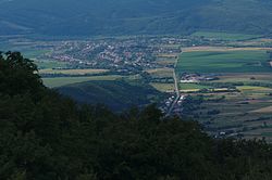 | |
 Belá nad Cirochou Location of Belá nad Cirochou in the Prešov Region | |
| Coordinates: 48°58′N 22°06′E / 48.967°N 22.100°ECoordinates: 48°58′N 22°06′E / 48.967°N 22.100°E | |
| Country | |
| Region | Prešov |
| District | Snina |
| First mentioned | 1451 |
| Area | |
| • Total | 17.356 km2 (6.701 sq mi) |
| Elevation | 207 m (679 ft) |
| Population | |
| • Total | 3,315 |
| • Density | 190/km2 (490/sq mi) |
| Time zone | UTC+1 (CET) |
| • Summer (DST) | UTC+2 (CEST) |
| Postal code | 067 81 |
| Area code(s) | 421-57 |
| Car plate | SV |
| Website | www |


Belá nad Cirochou (Rusyn: Бела над Цірохов, Hungarian: Cirókabéla) is a large village and municipality in Snina District in the Prešov Region of north-eastern Slovakia.
History[]
In historical records the village was first mentioned in 1451.
Geography[]
The municipality lies at an altitude of 207 metres and covers an area of 17.356 km2. It has a population of about 3315 people.
Genealogical resources[]
The records for genealogical research are available at the state archive "Statny Archiv in Presov, Slovakia"
- Roman Catholic church records (births/marriages/deaths): 1786–1895 (parish B)
- Greek Catholic church records (births/marriages/deaths): 1825–1895 (parish B)
See also[]
External links[]
 Media related to Belá nad Cirochou at Wikimedia Commons
- Official website

- https://web.archive.org/web/20070427022352/http://www.statistics.sk/mosmis/eng/run.html
- Surnames of living people in Bela nad Cirochou
| Authority control |
|
|---|
This Prešov Region geography article is a stub. You can help Wikipedia by . |
Categories:
- Villages and municipalities in Snina District
- Prešov Region geography stubs