Stakčín
Stakčín | |
|---|---|
Municipality | |
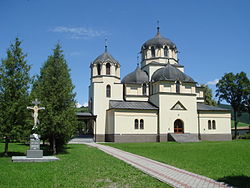 Orthodox church of the Holy Trinity | |
 Stakčín Location of Stakčín in the Prešov Region | |
| Coordinates: 49°00′10″N 22°14′30″E / 49.00278°N 22.24167°ECoordinates: 49°00′10″N 22°14′30″E / 49.00278°N 22.24167°E | |
| Country | |
| Region | Prešov |
| District | Snina |
| First mentioned | 1567 |
| Area | |
| • Total | 167.742 km2 (64.766 sq mi) |
| Elevation | 257 m (843 ft) |
| Population (31 December 2013) | |
| • Total | 2,452 |
| • Density | 15/km2 (38/sq mi) |
| Time zone | UTC+1 (CET) |
| • Summer (DST) | UTC+2 (CEST) |
| Postal code | 067 61 |
| Area code(s) | 421-57 |
| Car plate | SV |
| Website | stakcin |


Stakčín (Hungarian: Takcsány) is a larger village and a municipality in Snina District in the Prešov Region of north-eastern Slovakia.
Geography[]
The municipality lies in the Cirocha river valley, at an altitude of 257 metres and with a total area of 167.742 km² it is perhaps the largest municipality in the entire country of Slovakia. According to the 2013 census it had a population of 2452 inhabitants. It lies between the Vihorlat and Bukovské vrchy mountains. The municipality is the seat of the Poloniny National Park governing body.
History[]
In historical records the village was first mentioned in 1492 as Staccyn. The area was a battleground in the Slovak-Hungarian War.
Twin towns — sister cities[]
Stakčín is twinned with:[1]
References[]
- ^ "Partnerstvo". stakcin.eu (in Slovak). Stakčín. Retrieved 2019-09-09.
External links[]
 Media related to Stakčín at Wikimedia Commons
- Official website

| show Municipalities of Snina District |
|---|
| show Authority control |
|---|
This Prešov Region geography article is a stub. You can help Wikipedia by . |
- Stakčín
- Zemplín (region)
- Prešov Region geography stubs