Belle Isle Marsh Reservation
| Belle Isle Marsh Reservation | |
|---|---|
 Egrets in the marsh | |
 Location in Massachusetts | |
| Location | East Boston, Winthrop, and Revere |
| Coordinates | 42°23′21″N 70°59′21″W / 42.38917°N 70.98917°WCoordinates: 42°23′21″N 70°59′21″W / 42.38917°N 70.98917°W[1] |
| Area | 188 acres (76 ha)[2] |
| Elevation | 0 ft (0 m)[1] |
| Established | 1985 |
| Operator | Massachusetts Department of Conservation and Recreation |
| Website | Belle Isle Marsh Reservation |

Belle Isle Marsh Reservation in Suffolk County, Massachusetts is an urban nature preserve and public recreation area containing mostly coastal wetlands.[3] The Reservation includes the last remnant within Boston of the salt marshes that were once prevalent along the Massachusetts Bay shoreline.[4] The marsh is home to a wide variety of saltmarsh plants, marine life, and birds.[5] The reservation is managed by the Department of Conservation and Recreation.
History[]
Although it is now connected to the mainland, Belle Isle was formerly an actual island. It was granted in 1628 to William Brereton, who named it Susana Island in honor of his daughter.[6] It was later referred to as Hog Island or Hogg Island on maps,[7] before it was purchased by Joseph Russel near the end of the 18th century, who named it Belle Isle.[8] In 1800, it was purchased by John Breed, who lived on the island, which was then referred to as Breed's Island.[6] Part of the island is now developed as Orient Heights; much of the remainder is Belle Isle Marsh.
Activities and amenities[]
Features of the reservation include landscaped hiking paths, benches, an observation tower, and handicap access.[4] A portion of the Boston Harborwalk runs through the reservation.
Gallery[]
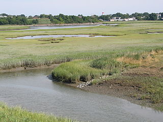
View of the marsh

Homes in Revere adjacent to the marsh

From the observation tower

Great egrets

Marsh with Boston skyline in the distance


References[]
- ^ a b "Belle Isle Inlet Marshes". Geographic Names Information System. United States Geological Survey.
- ^ "2012 Acreage Listing" (PDF). Department of Conservation and Recreation. April 2012. Retrieved February 16, 2017.
- ^ Laidler, John (September 21, 2018). "Paths, park, and pavilion unveiled in Winthrop - The Boston Globe". The Boston Globe. Retrieved 2018-10-20.
- ^ a b "Belle Isle Marsh Reservation". Department of Conservation and Recreation. Retrieved May 28, 2021.
- ^ "Site Summary: Belle Isle Marsh". Mass Audubon. Retrieved 2018-10-20.
- ^ a b Sweetser, Moses Foster (1888). King's Handbook of Boston Harbor. Moses King Corporation.
- ^ J. De Costa (1775). A plan of the town and harbour of Boston and the country adjacent with the road from Boston to Concord (Map). 1:120,000. London. Retrieved 2018-10-21.
- ^ Sumner, William Hyslop (1858). A history of East Boston; with biographical sketches of its early proprietors, and an appendix. Boston: J. E. Tilton and Company.
External links[]
| Wikimedia Commons has media related to Belle Isle Marsh. |
- Belle Isle Marsh Reservation Department of Conservation and Recreation
- Belle Isle Marsh Reservation Map Department of Conservation and Recreation
- Friends of Belle Isle Marsh
- State parks of Massachusetts
- Parks in Boston
- East Boston
- Protected areas established in 1985
- 1985 establishments in Massachusetts