Berks, Nebraska
Berks, Nebraska | |
|---|---|
 | |
 Berks Location in Nebraska | |
| Coordinates: 40°39′31″N 96°54′49″W / 40.65861°N 96.91361°WCoordinates: 40°39′31″N 96°54′49″W / 40.65861°N 96.91361°W | |
| Country | United States |
| State | Nebraska |
| County | Lancaster |
| Elevation | 1,417 ft (432 m) |
| Time zone | UTC-6 (Central (CST)) |
| • Summer (DST) | UTC-5 (CDT) |
| ZIP codes | 68333 |
| GNIS feature ID | 835247 |


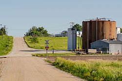
Berks is an unincorporated community in Lancaster and Saline counties, Nebraska, United States.[1] The community is located approximately three miles northeast of Crete on the Burlington Northern Railroad Line and one-half mile north of Nebraska Highway 33.[2]
History[]
Some people hold Berks was the name of an early settler, while others believe the community was named after Berks County, Pennsylvania.[3] The name was also probably chosen to conform with the alphabetical stops on the new Burlington & Quincy Railroad line traveling westward from Lincoln: Berks, Crete, Dorchester, Exeter, Fairmont, Grafton, Huxley, etc.[4] The Berks post office was discontinued in 1912.[5]
References[]
- ^ U.S. Geological Survey Geographic Names Information System: Berks, Nebraska
- ^ Crete North, Nebraska, 7.5 Minute Topographic Quadrangle, USGS, 1964
- ^ Fitzpatrick, Lillian L. (1960). Nebraska Place-Names. University of Nebraska Press. p. 91. ISBN 0-8032-5060-6. A 1925 edition is available for download at University of Nebraska—Lincoln Digital Commons.
- ^ "Saronville, Clay County". Center for Advanced Land Management Information Technologies. University of Nebraska. Retrieved 22 February 2018.
- ^ "Lancaster County". Jim Forte Postal History. Archived from the original on 20 August 2014. Retrieved 19 August 2014.
Municipalities and communities of Lancaster County, Nebraska, United States | ||
|---|---|---|
| Cities | ||
| Villages | ||
| CDPs | ||
| Other communities | ||
| Footnotes | ‡This populated place also has portions in an adjacent county or counties | |
| ||
Municipalities and communities of Saline County, Nebraska, United States | ||
|---|---|---|
| Cities | ||
| Villages | ||
| Unincorporated communities | ||
| Footnotes | ‡This populated place also has portions in an adjacent county or counties | |
| ||
This Lancaster County, Nebraska state location article is a stub. You can help Wikipedia by . |
This Saline County, Nebraska state location article is a stub. You can help Wikipedia by . |
- Unincorporated communities in Lancaster County, Nebraska
- Unincorporated communities in Saline County, Nebraska
- Unincorporated communities in Nebraska
- Eastern Nebraska geography stubs