Berzosa del Lozoya
show This article may be expanded with text translated from the corresponding article in Spanish. (June 2012) Click [show] for important translation instructions. |
Berzosa del Lozoya | |
|---|---|
 Flag  Coat of arms | |
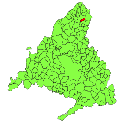 | |
 Berzosa del Lozoya Location in Spain | |
| Coordinates: 40°58′31″N 3°31′28″W / 40.97528°N 3.52444°WCoordinates: 40°58′31″N 3°31′28″W / 40.97528°N 3.52444°W | |
| Country | |
| Autonomous community | |
| Province | |
| Area | |
| • Total | 14.3 km2 (5.5 sq mi) |
| Elevation | 1,094 m (3,589 ft) |
| Population (2018)[1] | |
| • Total | 198 |
| • Density | 14/km2 (36/sq mi) |
| Time zone | UTC+1 (CET) |
| • Summer (DST) | UTC+2 (CEST) |
| Postal code | 28194 |

Berzosa de Lozoya (Spanish pronunciation: [beɾˈθosa ðe loˈθoʝa]) is a municipality situated in the north of the autonomous community of Madrid in central Spain.[2] It had 234 inhabitants in 2011, covers an area of 14.3 km² and a population density of 16.36people per km².

City Hall
Education[]
There is one nursery (public) in Berzosa del Lozoya.
References[]
- ^ Municipal Register of Spain 2018. National Statistics Institute.
- ^ Los 'nuevos vecinos' de Berzosa, el único consuelo, El País, 16 March 2004
External links[]
| Wikimedia Commons has media related to Berzosa del Lozoya. |
| show Municipalities of the Community of Madrid |
|---|
| Authority control |
|
|---|
This Spain-related article is a stub. You can help Wikipedia by . |
Categories:
- Municipalities in the Community of Madrid
- Spain stubs