Bibrka
Bibrka
Бі́брка Bóbrka | |
|---|---|
City | |
 Skyline of Bibrka | |
 Flag  Coat of arms | |
| Country | |
| Oblast | |
| Raion | Peremyshliany Raion |
| Population (2021) | |
| • Total | 3,810 |
| Time zone | GMT+2 |
Bíbrka (Ukrainian: Бі́брка; Polish: Bóbrka; Yiddish: בוברקא, romanized: Bubrka) is a town in western Ukraine, located in Peremyshliany Raion of Lviv Oblast (region) about 29 km southeast of Lviv on H09. Its population is approximately 3,810 (2021 est.)[1].
The town has been ruled at various points by the Kingdom of Poland, Polish–Lithuanian Commonwealth, the Austrian Empire, the Kingdom of Galicia and Lodomeria, the Russian Empire, Poland, the Soviet Union, and is now part of the Lviv Oblast in Ukraine; as a result Bibrka has several official and native names, including: Bóbrka (Polish/Russian), Prachnik (German), and Boiberik/Boyberke (Yiddish). The city has a population of 3,980.
Bibrka was the site of a Soviet prison and detention centre that detained Poles and others in the mid-20th century.
History[]
This section needs expansion. You can help by . (May 2013) |
From the first partition of Poland in 1772 until 1918, the town was part of the Austrian monarchy (Austria side after the compromise of 1867), head of the BOBRKA district, one of the 78 Bezirkshauptmannschaften in Austrian Galicia province (Crown land) in 1900.[2] The fate of this province was then disputed between Poland and Russia, until the Peace of Riga in 1921. In the middle of 1941, approximately 2,000 Jews lived in Birbrka. The Germans commenced their occupation of the town during World War II on June 30, 1941. In 1942, the Germans created a ghetto for the remaining 1,500 - 1,900 Jews who had not been deported to the Bełzec extermination camp. Approximately 300 Jews died in the ghetto due to disease and illness. The ghetto was liquidated on April 13, 1943, during which over 1,300 Jews were killed on a site in the nearby village of Volove.[3]
The region was annexed by the Soviet Union in 1945.
Gallery[]
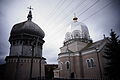
Epiphany Church in Bibrka
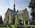
St. Nicholas Church

A street in Bibrka

City park


References[]
- ^ "Чисельність наявного населення України (Actual population of Ukraine)" (PDF) (in Ukrainian). State Statistics Service of Ukraine. Retrieved 11 July 2021.
- ^ Die postalischen Abstempelungen auf den österreichischen Postwertzeichen-Ausgaben 1867, 1883 und 1890, Wilhelm KLEIN, 1967
- ^ "Yahad-In Unum Interactive Map". Extermination Sites of Jewish Victims Investigated by Yahad-In Unum. Retrieved 20 January 2015.
External links[]
- (in Polish) Bóbrka (Bibrka) in the Geographical Dictionary of the Kingdom of Poland (1880)
- JewishGen ShtetLinks, Bóbrka by Bev Shulster. Retrieved 25 May 2006
- My Bibrka (in Ukrainian)
- Bobrka, Ukraine at JewishGen
| show Authority control |
|---|
Coordinates: 49°37′N 24°14′E / 49.617°N 24.233°E

This article about a location in Lviv Oblast is a stub. You can help Wikipedia by . |
- Cities in Lviv Oblast
- Kingdom of Galicia and Lodomeria
- Lwów Voivodeship
- Shtetls
- Cities of district significance in Ukraine
- Holocaust locations in Ukraine
- Lviv Oblast geography stubs