Sudova Vyshnia
This article needs additional citations for verification. (March 2012) |
Sudova Vyshnia
Судова Вишня Sądowa Wisznia | |
|---|---|
City | |
 Town hall | |
 Flag  Coat of arms | |
 Sudova Vyshnia | |
| Coordinates: 49°47′21″N 23°22′20″E / 49.78917°N 23.37222°E | |
| Country | |
| Oblast | |
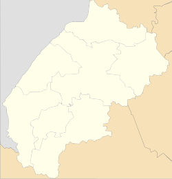
| Raion | Mostyska Raion |
| First mentioned | 1230 |
| Magdeburg law | 1368 |
| Population (2021) | |
| • Total | 6,504 |
| Time zone | UTC+2 (EET) |
| • Summer (DST) | UTC+3 (EEST) |
| Postal code | 81340 |
| Area code(s) | +380 |


Sudóva Výšnja (Ukrainian: Судова Вишня, Polish: Sądowa Wisznia) is a town of Mostyska Raion in Lviv Oblast (region) of Ukraine. Population: 6,504 (2021 est.)[1].
The town has a number of Catholic cathedrals, a secondary school, is a market centre for surrounding agricultural area. In the past the town contained a horse farm, providing horse stud service for the area, some of the horse studs being very expensive. On outskirts there is a hippodrome.
Location[]
Sudova Vyshnia is located about 50 km west of Lviv, on the highway ![]() M 11 (Shehyni – Lviv) and railroad to Przemyśl in Poland. In the city also terminates a route P40 that stretches all the way to Rava-Ruska.
M 11 (Shehyni – Lviv) and railroad to Przemyśl in Poland. In the city also terminates a route P40 that stretches all the way to Rava-Ruska.
The Vishnya river flows through the town in a westerly direction, eventually joining San in Poland. The railway line (twin track) leads to Kraków and Silesia in Poland, being a main route carrying coal to the former USSR.
History[]
Sudova Vyshnia was first mentioned in Galician–Volhynian Chronicle for 1230 as Vyshnia. In 1340, together with whole Red Ruthenia, it was annexed by the Kingdom of Poland. Until the 1772 Partitions of Poland, Sądowa Wisznia, as it was officially called, was part of Przemyśl Land, Ruthenian Voivodeship.
Sudova Vyshnia received its Magdeburg rights town charter in 1368. Originally, it was called Vyshnia (Wisznia), after the river Wisznia, a tributary of the San. The adjective Sudova (Polish: Sądowa) was added in 1545, when it became the seat of the general sejmiks of the Ruthenian szlachta of Lesser Poland Province of the Polish Crown.
In 1772, the town was annexed by the Habsburg Empire, as part of Habsburg Austrian Galicia, where it remained until late 1918. In the Second Polish Republic, Sądowa Wisznia belonged to Mościska County, Lwów Voivodeship. During the September 1939 Invasion of Poland, the Battle of Jaworów took place in the area of the town.
When captured by the USSR in the Second World War, the town had a large main square, cobbled and with a podium – suitable for public meetings. Under Communism, the square was planted over by trees and bushes – no more public meetings. In 1940–41 and 1944–59 Sudova Vyshnia was a district seat of the Sudova Vyshnia Raion that eventually was merged with Mostyska Raion.
When under Nazi Germany administration during the Second World War, being in the area called Galicia since ancient times, it was not considered occupied but a part of the German Reich. The currency at that time was the Reichsmark, whereas in occupied territories German administration was using Ostmark. German armed forces included a number of SS divisions, considered to be elite units. And there was a division SS Galicia. Before the war the town had had a Jewish population; only 3 (two of which are: Frieda Stramer and her brother Dov Stramer) of its Jews survived the war, and none remained there afterwards.
After World War II, the Soviet regime used a Catholic temple (Church of St Mary) that existed since the 14th century as a warehouse until 1989.
Today, Sudova Vyshnia is one of the centers of the Poles in Ukraine, with a local office of the Association of Polish Culture of the Lviv Land.
Notable people[]
Born[]
- Ivan Vyshenskyi (1550–1620), an Eastern Orthodox monk
- Stefan Czmil (1914–1978), an Eastern Catholic bishop
- Bohdan Shust (1986 – ), a professional football player
Resided[]
- Jan Mars (1853–1924), an owner of Sudova Vyshnia
- Marcin Krowicki (1501–1573), a priest who converted from Catholicism to Unitiarianism
Gallery[]

Sudova Vyshnia school

City's oldest church, Transfiguration Church
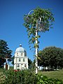
Transfiguration Church Bell Tower

Holy Trinity Church
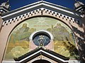
Holy Trinity Church, entrance fresco

a street view

Church of St Mary, a Helper of Christians


References[]
- ^ "Чисельність наявного населення України (Actual population of Ukraine)" (PDF) (in Ukrainian). State Statistics Service of Ukraine. Retrieved 11 July 2021.
External links[]
- Brief info[permanent dead link] at the Verkhovna Rada website
- Sudova Vyshnia at the Castles and temples of Ukraine
| show Authority control |
|---|
Coordinates: 49°47′21″N 23°22′20″E / 49.78917°N 23.37222°E
- Cities in Lviv Oblast
- Cities of district significance in Ukraine
- Ruthenian Voivodeship
- Holocaust locations in Ukraine