Big Bend (Texas)
The Big Bend is part of the Trans-Pecos region in southwestern Texas, United States along the border with Mexico, north of the prominent bend in the Rio Grande for which the region is named.[1] Here the Rio Grande passes between the Chisos Mountains in Texas and the Sierra Madre Oriental in Mexico as it changes from running east-southeast to north-northeast. The region covers three counties: Presidio County to the west, Brewster County to the east, and Jeff Davis County to the north.[2]
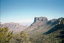
The region is sparsely populated, arid, and rugged, containing the Chisos Mountains and the Davis Mountains. The region has more than 1 million acres (4,000 km2) of public lands, including Big Bend National Park and Big Bend Ranch State Park along the north side of the Rio Grande. It is also the home of the McDonald Observatory.
The largest towns in the region are Alpine, Presidio, Marfa, Sanderson, Terlingua, and Marathon. The counties are Presidio County, Jeff Davis County, Brewster County, Pecos County, and Terrell County.
See also[]
References[]
- ^ Fehrenbach, T. R. (1985). Texas : a salute from above. San Antonio, Tex.: Texas Books, World Pub. Services in association with K. Weldon, McMahons Point, NSW, Australia. ISBN 0-940672-28-6. OCLC 12320665.
- ^ Tinkham, E. (1935). "The Mutillidae of Presidio and Jeff Davis Counties of the Big Bend Region of Trans-Pecos Texas". The Canadian Entomologist. 67 (10): 207–211. doi:10.4039/Ent67207-10.
Further reading[]
- Morey, Roy (2008). Little Big Bend: Common, Uncommon, and Rare Plants of Big Bend National Park. Texas Tech University Press. ISBN 978-0-89672-613-0.
External links[]
| Wikimedia Commons has media related to Big Bend (Texas). |
- The Big Bend of Texas., 1920, hosted by the Portal to Texas History
- West Texas Weekly- a local weekly newspaper.
- Visit Big Bend- an extensive website on the Big Bend region and attractions.

| Authority control |
|
|---|
Coordinates: 30°N 103°W / 30°N 103°W

This Texas state location article is a stub. You can help Wikipedia by . |
- Regions of Texas
- Big Bend National Park
- Texas geography stubs