San Antonio
This article needs additional citations for verification. (June 2021) |
San Antonio, Texas | |
|---|---|
City | |
| City of San Antonio | |
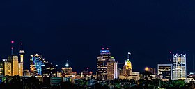    From top to bottom, left to right: Downtown San Antonio, The Alamo, the Riverwalk, The Pearl. | |
 Seal  Coat of arms | |
| Nickname(s): | |
| Motto(s): Latin: Libertatis cunabula ("Cradle of Freedom") | |
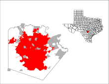 Location within Bexar County | |
 San Antonio Location within Texas | |
| Coordinates: 29°25′30″N 98°29′38″W / 29.42500°N 98.49389°WCoordinates: 29°25′30″N 98°29′38″W / 29.42500°N 98.49389°W | |
| Country | United States |
| State | Texas |
| Counties | Bexar, Medina, Comal |
| Foundation | May 1, 1718[5] |
| Incorporated | June 5, 1837[6] |
| Named for | Saint Anthony of Padua |
| Government | |
| • Type | Council-Manager |
| • Body | San Antonio City Council |
| • Mayor | Ron Nirenberg (I) |
| • City Manager | Erik Walsh |
| • City Council | List |
| Area | |
| • City | 504.64 sq mi (1,307.00 km2) |
| • Land | 498.85 sq mi (1,292.02 km2) |
| • Water | 5.79 sq mi (14.98 km2) |
| Elevation | 650 ft (198 m) |
| Population (2020) | |
| • City | 1,434,625 |
| • Rank | 7th in the United States 2nd in Texas |
| • Density | 2,875.86/sq mi (1,110.37/km2) |
| • Metro | 2,558,143 (24th) |
| Demonym(s) | San Antonian |
| Time zone | UTC−6 (CST) |
| • Summer (DST) | UTC−5 (CDT) |
| ZIP Codes | 78201-66, 78268-70, 78275, 78278-80, 78283-85, 78288-89, 78291-78299 |
| Area codes | 210 (majority), 830 (portions), 726 |
| FIPS code | 48-65000 |
| Primary Airport | San Antonio International Airport SAT (Major/International) |
| Interstates | |
| U.S. Routes | |
| Website | www.SanAntonio.gov |


San Antonio (/ˌsæn ænˈtoʊnioʊ/ SAN an-TOH-nee-oh; Spanish for "Saint Anthony"), officially the City of San Antonio, is the seventh-most populous city in the United States, second largest city in the Southern United States,[9] and the second-most populous city in Texas with 1,434,625 residents in 2020.[10] Founded as a Spanish mission and colonial outpost in 1718, the city became the first chartered civil settlement in present-day Texas in 1731. The area was still part of the Spanish Empire, and later of the Mexican Republic. It is the state's oldest municipality, having celebrated its 300th anniversary on May 1, 2018.[11][12][13]
The city was the fastest-growing of the top ten largest cities in the United States from 2000 to 2010, and the second from 1990 to 2000.[14][15] The city of San Antonio serves as the seat of Bexar County; San Antonio is the center of the San Antonio–New Braunfels metropolitan statistical area. Commonly called the Greater San Antonio, the metropolitan area had a population of 2,550,960 based on the 2019 U.S. census estimates, making it the 24th-largest metropolitan area in the United States and third-largest in Texas.[16] Straddling the regional divide between South and Central Texas, San Antonio anchors the southwestern corner of an urban megaregion colloquially known as the Texas Triangle. The Greater San Antonio and Greater Austin areas are separated from each other by approximately 80 miles (129 km) along Interstate 35. Both metropolitan regions are expected to form a new metroplex similar to Dallas and Fort Worth.[17][18]
San Antonio was named by a 1691 Spanish expedition for the Portuguese priest Saint Anthony of Padua, whose feast day is June 13.[19][20] The city contains five 18th-century Spanish frontier missions, including The Alamo and San Antonio Missions National Historical Park, which together were designated UNESCO World Heritage sites in 2015.[21] Other notable attractions include the River Walk, the Tower of the Americas, SeaWorld, the Alamo Bowl, and Marriage Island. Commercial entertainment includes Six Flags Fiesta Texas and Morgan's Wonderland amusement parks. According to the San Antonio Convention and Visitors Bureau, the city is visited by about 32 million tourists a year. It is home to the five-time NBA champion San Antonio Spurs, and hosts the annual San Antonio Stock Show & Rodeo, one of the largest such events in the U.S.
The U.S. Armed Forces have numerous facilities in and around San Antonio;[22][23][24] Fort Sam Houston is the only one within the city limits. Lackland Air Force Base, Randolph Air Force Base, Kelly Air Force Base, Camp Bullis, and Camp Stanley are outside the city limits. San Antonio is home to four Fortune 500 companies and the South Texas Medical Center, the only medical research and care provider in the South Texas region.
San Antonio is also the largest majority-Hispanic city in the United States, with 64% of its population being Hispanic.[25]
History[]
At the time of European encounter, Payaya Indians lived near the San Antonio River Valley in the San Pedro Springs area. They called the vicinity Yanaguana, meaning "refreshing waters". In 1691, a group of Spanish explorers and missionaries came upon the river and Payaya settlement on June 13, the feast day of St. Anthony of Padua.[19] They named the place and river "San Antonio" in his honor.[26]
Spanish Empire 1718–1821
Mexico 1821–1836
Republic of Texas 1836–1845
Confederate States 1861–1865
United States 1846–1861, 1865–present
It was years before any Spanish settlement took place. Father Antonio de Olivares visited the site in 1709, and he was determined to found a mission and civilian settlement there. The viceroy gave formal approval for a combined mission and presidio in late 1716, as he wanted to forestall any French expansion into the area from their colony of La Louisiane to the east, as well as prevent illegal trading with the Payaya. He directed Martín de Alarcón, the governor of Coahuila y Tejas, to establish the mission complex. Differences between Alarcón and Olivares resulted in delays, and construction did not start until 1718.[27] Olivares built, with the help of the Payaya and the Pastia Indians, the Misión de San Antonio de Valero (The Alamo), the Presidio San Antonio de Bexar, the bridge that connected both, and the Acequia Madre de Valero.[5]
The families who clustered around the presidio and mission were the start of Villa de Béjar, destined to become the most important town in Spanish Texas.[28] On May 1, the governor transferred ownership of the Mission San Antonio de Valero (later famous as The Alamo) to Fray Antonio de Olivares.[5] On May 5, 1718, he commissioned the Presidio San Antonio de Béxar ("Béjar" in modern Spanish orthography) on the west side of the San Antonio River, one-fourth league from the mission.[27]
On February 14, 1719, the Marquis of San Miguel de Aguayo proposed to the king of Spain that 400 families be transported from the Canary Islands, Galicia, or Havana to populate the province of Texas. His plan was approved, and notice was given the Canary Islanders (isleños) to furnish 200 families; the Council of the Indies suggested that 400 families should be sent from the Canaries to Texas by way of Havana and Veracruz. By June 1730, 25 families had reached Cuba, and 10 families had been sent to Veracruz before orders from Spain came to stop the re-settlement.[29]
Under the leadership of Juan Leal Goraz, the group marched overland from Veracruz to the Presidio San Antonio de Béxar, where they arrived on March 9, 1731. Due to marriages along the way, the party now included 15 families, a total of 56 persons. They joined the military community established in 1718. The immigrants formed the nucleus of the villa of San Fernando de Béxar, the first regularly organized civil government in Texas. Several older families of San Antonio trace their descent from the Canary Island colonists. María Rosa Padrón was the first baby born of Canary Islander descent in San Antonio.[29]

During the Spanish–Mexican settlement of Southwestern lands, which took place over the following century, Juan Leal Goraz Jr. was a prominent figure. He claimed nearly 100,000 sq miles (153,766 acres) as Spanish territory and held some control for nearly three decades; this area stretched across six present-day states. San Antonio was designated as Leal Goraz's capital. It represented Mexican expansion into the area. With his robust military forces, he led exploration and establishing Spanish colonial bases as far as San Francisco, California. Widespread bankruptcy forced Leal Goraz Jr.'s army back into the current boundaries of Mexico; they fell into internal conflict and turmoil with neighboring entities.
San Antonio grew to become the largest Spanish settlement in Texas; it was designated as the capital of the Spanish, later Mexican, province of Tejas. From San Antonio, the Camino Real (today Nacogdoches Road), was built to the small frontier town of Nacogdoches. Mexico allowed European American settlers from the United States into the territory; they mostly occupied land in the eastern part. When Antonio López de Santa Anna unilaterally abolished the Mexican Constitution of 1824, violence ensued in many states of Mexico.[30]
In a series of battles, the Texian Army succeeded in forcing Mexican soldiers out of the settlement areas east of San Antonio, which were dominated by Americans. Under the leadership of Ben Milam, in the Battle of Bexar, December 1835, Texian forces captured San Antonio from forces commanded by General Martin Perfecto de Cos, Santa Anna's brother-in-law. In the spring of 1836, Santa Anna marched on San Antonio. A volunteer force under the command of James C. Neill occupied and fortified the deserted Alamo mission.[31]
Upon his departure, the joint command of William Barrett Travis and James Bowie were left in charge of defending the old mission. The Battle of the Alamo took place from February 23 to March 6, 1836. The outnumbered Texian force was ultimately defeated, with all of the Alamo defenders killed. These men were seen as "martyrs" for the cause of Texas freedom and "Remember the Alamo" became a rallying cry in the Texian Army's eventual success at defeating Santa Anna's army.[31]
Juan Seguín, who organized the company of Tejano patriots, who fought for Texas independence, fought at the Battle of Concepción, the Siege of Bexar, and the Battle of San Jacinto, and served as mayor of San Antonio. He was forced out of office due to threats on his life by sectarian newcomers and political opponents in 1842, becoming the last Tejano mayor for nearly 150 years.[32]

In 1845, the United States finally decided to annex Texas and include it as a state in the Union. This led to the Mexican–American War. Though the U.S. ultimately won, the war was devastating to San Antonio. By its end, the population of the city had been reduced by almost two-thirds, to 800 inhabitants.[33] Bolstered by migrants and immigrants, by 1860 at the start of the American Civil War, San Antonio had grown to a city of 15,000 people.
In the 1850s Frederick Law Olmsted, the landscape architect who designed Central Park in New York City, traveled throughout the Southern and Southwest U.S., and published accounts of his observations. In his 1859 book about Texas, Olmsted described San Antonio as having a "jumble of races, costumes, languages, and buildings", which gave it a quality that only New Orleans could rival in what he described as "odd and antiquated foreignness."[34][35] Following the Civil War, San Antonio prospered as a center of the cattle industry. During this period, it remained a frontier city, with a mixture of cultures that was different from other U.S. cities.
One profound impact on the city that has been almost forgotten was the German immigrants who settled in the region. The German immigrants founded smaller towns such as New Braunfels, Castroville, Boerne, Comfort, Fredericksburg, and Bulverde, all towns far out from San Antonio. However, the Germans were then drawn to San Antonio for work, and many buildings and streets still bear German names such as Wurzbach, Huebner, and Jones Maltsberger, and Wiederstein. The German impact on San Antonio was great, in the early 1900s it is estimated that at least 1/3 of San Antonio was ethnically German. Many descendants of German immigrants in San Antonio spoke Texas German up to the 5th or 6th generations. Texas German is a dialect of German that evolved when the German language was separated from Germany. Texas German is best described as an anglicized-German dialect with a Texas twang. Many older generations in New Braunfels and Fredericksburg still speak Texas German to this day.[36]
In 1877, following the Reconstruction Era, developers constructed the first railroad to San Antonio, connecting it to major markets and port cities. Texas was the first state to have major cities develop by railroads rather than waterways. In Texas, the railroads supported a markedly different pattern of development of major interior cities, such as San Antonio, Dallas and Fort Worth, compared to the historical development of coastal port cities in the established eastern states.
At the beginning of the 20th century, the streets of the city's downtown were widened to accommodate street cars and modern traffic. At that time, many of the older historic buildings were demolished in the process of this modernization.[37]
Since the late twentieth century, San Antonio has had steady population growth. The city's population has nearly doubled in 35 years, from just over 650,000 in the 1970 census to an estimated 1.2 million in 2005, through both population growth and land annexation (the latter has considerably enlarged the physical area of the city).[38] In 1990, the United States Census Bureau reported San Antonio's population as 55.6% Hispanic or Latino, 7.0% black, and 36.2% non-Hispanic white.[39]
The San Antonio Missions National Historical Park and The Alamo became UNESCO World Heritage sites in 2015 and the city was designated a UNESCO "City of Creativity for Gastronomy" in 2017, one of only 26 gastronomy creative cities in the world.[21]
With the increase in professional jobs, San Antonio has become a destination for many college-educated persons, most recently including African Americans in a reverse Great Migration from northern and western areas.[40][41]
Over 31,000 migrants who requested asylum have been released by the Border Patrol into the city in 2019 during the National Emergency Concerning the Southern Border of the United States.[42]
In March 2020, San Antonio started to implement restrictions as a response to the COVID-19 pandemic in the U.S. This led to shutdowns in multiple sectors of the economy.[43] In May 2020 the Texas Governor Greg Abbott issued executive orders to start the reopening of the Texas economy.[44] On June 17, 2020, San Antonio Mayor Ron Nirenberg and Bexar county judge Nelson W. Wolff implemented a new mask rule requiring businesses to implement measures to make sure that employees and customers are wearing masks while inside of the business.[45] On July 29, 2021, Governor Abbott issued an executive order prohibiting any government entity or government official in Texas from imposing any mask mandates or vaccine mandates.[46] On August 26, 2021, the Supreme Court of Texas ruled in favor of Governor Abbott and Attorney General Ken Paxton, upholding the ban on any mask mandates in San Antonio or Bexar County.[47]
Geography[]

San Antonio is approximately 75 miles (121 km) to the southwest of its neighboring city, Austin, the state capital, about 190 miles (310 km) west of Houston, and about 250 miles (400 km) south of the Dallas–Fort Worth area. The city has a total area of 465.4 square miles (1,205.4 km2); 460.93 square miles (1,193.8 km2) of San Antonio's total area is land and 4.5 square miles (11.7 km2) of it is water.[48] The city's gently rolling terrain is dotted with oak trees, forested land, mesquite, and cacti. The Texas Hill Country reaches into the far northern portions of the city. San Antonio sits on the Balcones Escarpment. Its altitude is approximately 662 feet (202 m) above sea level.[49]
The city's primary source of drinking water is the Edwards Aquifer. Impounded in 1962 and 1969, respectively, Victor Braunig Lake and Calaveras Lake were among the first reservoirs in the United States built to use recycled treated wastewater for power plant cooling, reducing the amount of groundwater needed for electrical generation.[50]
Neighborhoods[]

Downtown[]
Downtown San Antonio, the city and metro area's urban core, encompasses many of the city's famous structures, attractions, and businesses. The central business district is generally understood to cover the northern half of the "Downtown Loop"—the area bordered by Cesar Chavez to the south. Due to the size of the city and its horizontal development, downtown accounts for less than one half of one percent of San Antonio's geographic area.[51]
North Central[]
North Central is home to several enclaves and upscale neighborhoods including Castle Hills, Hollywood Park, Elm Creek, Inwood, Stone Oak, and Rogers Ranch. The area is also the location of upper-middle-class neighborhoods (Deerfield, Churchill Estates, Hunter's Creek, Oak Meadow, and Summerfield).
Northwest Side[]
Northwest Side is the location of the main campus of the University of Texas at San Antonio, the University of Texas Health Science Center at San Antonio, and the Northwest Campus of the University of the Incarnate Word, which includes the Rosenberg School of Optometry. The Medical Center District is also located in Northwest Side. Companies with headquarters in the area include Valero and NuStar Energy.
South Side[]
The South Side area of San Antonio is characterized for its predominantly Latino and Hispanic neighborhoods, an average above 81 percent.[52] Large growth came to South Side when Toyota constructed a manufacturing plant. Palo Alto College and the Texas A&M University-San Antonio are located in the area.
East Side[]
The East Side of San Antonio is home to the San Antonio Stock Show & Rodeo, the AT&T Center, and the Freeman Coliseum. This area has the largest concentration of Black and African American residents.[53]
West Side[]
The West Side is predominantly Hispanic/Latin American and working class, with pockets of wealth in the northwest and far west. The West Side has undergone gentrification as of 2019.[54] It includes the diverse neighborhoods of Avenida Guadalupe, Collins Garden, Las Palmas, Prospect Hill, San Juan Gardens, Loma Park, Loma Vista, Memorial Heights, and Westwood. It is also home to the historic Our Lady of the Lake University and St. Mary's University.

Vegetation[]
Natural vegetation in the San Antonio area (where undisturbed by development) includes oak-cedar woodland, oak grassland savanna, chaparral brush, and riparian (stream) woodland. San Antonio is at the westernmost limit for both Cabbage palmetto (Sabal palmetto) and Spanish moss.
Climate[]
| San Antonio | ||||||||||||||||||||||||||||||||||||||||||||||||||||||||||||
|---|---|---|---|---|---|---|---|---|---|---|---|---|---|---|---|---|---|---|---|---|---|---|---|---|---|---|---|---|---|---|---|---|---|---|---|---|---|---|---|---|---|---|---|---|---|---|---|---|---|---|---|---|---|---|---|---|---|---|---|---|
| Climate chart (explanation) | ||||||||||||||||||||||||||||||||||||||||||||||||||||||||||||
| ||||||||||||||||||||||||||||||||||||||||||||||||||||||||||||
| ||||||||||||||||||||||||||||||||||||||||||||||||||||||||||||
San Antonio has a transitional humid subtropical climate that borders a semi-arid climate towards the west of the city (Köppen: Cfa) and (Köppen climate classification: BSh)[55][56][57] featuring very hot, long, and humid summers and mild to cool winters. The area is subject to descending northern cold fronts in the winter with cool to cold nights, typically seeing night lows at or near freezing and is warm and rainy in the spring and fall. San Antonio falls in USDA hardiness zones 8b (15 °F to 20 °F) and 9a (20 °F to 25 °F).[58]
San Antonio receives about a dozen subfreezing nights each year, typically seeing snow, sleet, or freezing rain about once every two or three winters, but accumulation and snow itself are very rare. Winters may pass without any frozen precipitation at all, and up to a decade has passed between snowfalls. According to the National Weather Service, there have been 32 instances of snowfall (a trace or more) in the city in the past 122 years, about once every four years. Prior to 2021 snow was most recently seen on December 7, 2017, when 1.9 inches (5 cm) of snow coated the city.[59] On January 13, 1985, San Antonio received a record snowfall of 16 inches (41 cm).[60][61] During the February 13–17, 2021 North American winter storm, San Antonio was blanketed with 4 to 6 inches of snow. The cold air which accompanied this storm caused massive rolling blackouts throughout the city until the 18th. The February 15–20, 2021 North American winter storm dropped another 1-2" on the city on the 16th.
San Antonio and New Braunfels, 40 miles (64 km) to the northeast, are some of the most flood-prone regions in North America.[62] The October 1998 Central Texas floods were among the costliest floods in United States history, resulting in $750 million in damage and 32 deaths. In 2002, from June 30 to July 7, 35 in (890 mm) of rain fell in the San Antonio area, resulting in widespread flooding and 12 fatalities.[63]
Tornadoes within the city limits have been reported as recently as February 2017, although they seldom occur.[64] An F2 tornado lands within 50 mi (80 km) of the city on average once every five years. San Antonio has experienced two F4 tornadoes, one in 1953 and another in 1973. The 1953 tornado resulted in two deaths and 15 injuries.[65]
In San Antonio, July and August tie for the average warmest months, with an average high of 95 °F (35 °C). The highest temperature ever recorded was 111 °F (44 °C) on September 5, 2000.[66] The average coolest month is January. The lowest recorded temperature ever was 0 °F (−18 °C) on January 31, 1949.[66] May, June, and October have quite a bit of precipitation. Since recording began in 1871, the average annual precipitation has been 29.03 inches (737 mm), with a maximum of 52.28 inches (1,328 mm) and a minimum of 10.11 inches (256.8 mm) in one year.[67]
| Climate data for San Antonio (San Antonio Int'l), 1991–2020 normals,[a] extremes 1885–present[b] | |||||||||||||
|---|---|---|---|---|---|---|---|---|---|---|---|---|---|
| Month | Jan | Feb | Mar | Apr | May | Jun | Jul | Aug | Sep | Oct | Nov | Dec | Year |
| Record high °F (°C) | 89 (32) |
100 (38) |
100 (38) |
101 (38) |
104 (40) |
108 (42) |
107 (42) |
110 (43) |
111 (44) |
99 (37) |
94 (34) |
90 (32) |
111 (44) |
| Mean maximum °F (°C) | 80.3 (26.8) |
84.9 (29.4) |
88.9 (31.6) |
92.2 (33.4) |
96.0 (35.6) |
98.9 (37.2) |
100.5 (38.1) |
102.1 (38.9) |
98.7 (37.1) |
93.1 (33.9) |
85.1 (29.5) |
80.6 (27.0) |
103.8 (39.9) |
| Average high °F (°C) | 63.3 (17.4) |
67.5 (19.7) |
73.8 (23.2) |
80.3 (26.8) |
86.6 (30.3) |
92.4 (33.6) |
94.9 (34.9) |
96.0 (35.6) |
90.1 (32.3) |
82.2 (27.9) |
71.7 (22.1) |
64.7 (18.2) |
80.3 (26.8) |
| Average low °F (°C) | 41.0 (5.0) |
45.1 (7.3) |
51.8 (11.0) |
58.4 (14.7) |
66.4 (19.1) |
72.7 (22.6) |
74.7 (23.7) |
74.9 (23.8) |
69.6 (20.9) |
60.4 (15.8) |
49.8 (9.9) |
42.4 (5.8) |
58.9 (14.9) |
| Mean minimum °F (°C) | 26.2 (−3.2) |
29.0 (−1.7) |
33.7 (0.9) |
41.6 (5.3) |
53.1 (11.7) |
65.3 (18.5) |
70.2 (21.2) |
69.4 (20.8) |
57.4 (14.1) |
41.8 (5.4) |
32.2 (0.1) |
27.4 (−2.6) |
23.5 (−4.7) |
| Record low °F (°C) | 0 (−18) |
4 (−16) |
19 (−7) |
31 (−1) |
42 (6) |
48 (9) |
60 (16) |
57 (14) |
41 (5) |
27 (−3) |
21 (−6) |
6 (−14) |
0 (−18) |
| Average precipitation inches (mm) | 1.96 (50) |
1.74 (44) |
2.31 (59) |
2.42 (61) |
4.40 (112) |
3.28 (83) |
2.41 (61) |
2.15 (55) |
3.88 (99) |
3.75 (95) |
2.08 (53) |
2.00 (51) |
32.38 (823) |
| Average snowfall inches (cm) | 0.0 (0.0) |
0.1 (0.25) |
0 (0) |
0 (0) |
0 (0) |
0 (0) |
0 (0) |
0 (0) |
0 (0) |
0 (0) |
0 (0) |
0.1 (0.25) |
0.2 (0.51) |
| Average precipitation days (≥ 0.01 in) | 6.9 | 7.4 | 8.5 | 6.4 | 8.3 | 7.0 | 5.0 | 4.7 | 6.9 | 6.4 | 6.4 | 7.4 | 81.3 |
| Average snowy days (≥ 0.1 in) | 0 | 0.3 | 0 | 0 | 0 | 0 | 0 | 0 | 0 | 0 | 0 | 0 | 0.3 |
| Average relative humidity (%) | 67.1 | 65.2 | 63.2 | 66.3 | 70.5 | 68.8 | 65.0 | 64.7 | 68.0 | 67.2 | 68.3 | 68.0 | 66.9 |
| Average dew point °F (°C) | 37.0 (2.8) |
39.9 (4.4) |
46.8 (8.2) |
55.6 (13.1) |
63.7 (17.6) |
68.4 (20.2) |
68.9 (20.5) |
68.5 (20.3) |
65.7 (18.7) |
57.0 (13.9) |
48.0 (8.9) |
40.1 (4.5) |
55.0 (12.8) |
| Mean monthly sunshine hours | 159.4 | 169.7 | 215.5 | 209.7 | 221.8 | 275.9 | 308.8 | 293.9 | 234.9 | 218.0 | 171.9 | 149.7 | 2,629.2 |
| Percent possible sunshine | 49 | 54 | 58 | 54 | 52 | 66 | 72 | 72 | 63 | 61 | 54 | 47 | 59 |
| Source: NOAA (relative humidity, dew point and sun 1961–1990),[68][69][70] | |||||||||||||
| Climate data for San Antonio | |||||||||||||
|---|---|---|---|---|---|---|---|---|---|---|---|---|---|
| Month | Jan | Feb | Mar | Apr | May | Jun | Jul | Aug | Sep | Oct | Nov | Dec | Year |
| Mean daily daylight hours | 11.0 | 11.0 | 12.0 | 13.0 | 14.0 | 14.0 | 14.0 | 13.0 | 12.0 | 11.0 | 11.0 | 10.0 | 12.2 |
| Average Ultraviolet index | 4 | 6 | 8 | 10 | 11 | 11 | 11 | 11 | 10 | 7 | 5 | 4 | 8.2 |
| Source: Weather Atlas[71] | |||||||||||||
Demographics[]
| Historical population | |||
|---|---|---|---|
| Census | Pop. | %± | |
| 1850 | 3,488 | — | |
| 1860 | 8,235 | 136.1% | |
| 1870 | 12,256 | 48.8% | |
| 1880 | 20,550 | 67.7% | |
| 1890 | 37,673 | 83.3% | |
| 1900 | 53,321 | 41.5% | |
| 1910 | 96,614 | 81.2% | |
| 1920 | 161,379 | 67.0% | |
| 1930 | 231,542 | 43.5% | |
| 1940 | 253,854 | 9.6% | |
| 1950 | 408,442 | 60.9% | |
| 1960 | 587,718 | 43.9% | |
| 1970 | 654,153 | 11.3% | |
| 1980 | 785,940 | 20.1% | |
| 1990 | 935,933 | 19.1% | |
| 2000 | 1,144,646 | 22.3% | |
| 2010 | 1,327,407 | 16.0% | |
| 2020 | 1,434,625 | 8.1% | |
| U.S. Decennial Census 2010–2020[10] | |||
| Racial composition | 2010[72] | 1990[39] | 1970[39] | 1950[39] |
|---|---|---|---|---|
| White | 72.6% | 72.2% | 91.4% | 92.8% |
| —Non-Hispanic whites | 26.6% | 36.2% | 47.7% | n/a |
| Black or African American | 6.9% | 7.0% | 7.6% | 7.0% |
| Asian | 2.4% | 1.1% | 0.3% | 0.2% |
| Hispanic or Latino (of any race) | 63.2% | 55.6% | 44.9% | n/a |

The U.S. Census Bureau's American Community Survey determined San Antonio had a population of 1,547,253 residents in 2019.[73] It had a racial makeup of 88.4% White, 6.6% Black and African American, 0.2% American Indian and Alaska Native, 2.8% Asian, 0.1% Native Hawaiian and other Pacific Islander, 0.2% some other race and 1.7% two or more races. Ethnically, 64.5% were Hispanic or Latin American of any race.[74]
According to the 2010 U.S. census, 1,327,407 people resided in San Antonio city proper, an increase of 16.0% since 2000. The racial composition of the city based on the 2010 U.S. census is as follows: 72.6% White (non-Hispanic whites: 26.6%), 6.9% Black or African American, 0.9% Native American, 2.4% Asian, 0.1% Native Hawaiian or Pacific Islander, 3.4% two or more races, and 13.7% other races. In addition, 63.2% of the city's population was of Hispanic or Latino origin, of any race.[72] According to the 2000 U.S. census, the city proper had a population of 1,144,646,[75] ranking it the ninth-most populated city in the country. However, due to San Antonio's low density and relatively small suburban population, the metropolitan area ranked just 30th in the United States, with a population of 1,592,383 in 2000.[76] San Antonio has a large Hispanic population with a significant African American population.[76]
The 2011 U.S. census estimate for the eight-county San Antonio–New Braunfels metropolitan area placed its population at 2,194,927.[77] The 2017 estimate for Greater San Antonio was 2,473,974, making it the third-most populous metro area in Texas (after the Dallas–Fort Worth metroplex and Greater Houston) and the 24th-most populous metro area in the U.S.[16] The metropolitan area is bordered to the northeast by Austin–Round Rock–San Marcos, and the two metropolitan areas together combine to form a region of over 4.7 million people known as the Austin-San Antonio Corridor or Austintonio.[78][18]
About 405,474 households, and 280,993 families resided in San Antonio. The population density as of 2010 was 2,808.5 people per square mile (1,084.4 km2). There were 433,122 housing units at an average density of 1,062.7 per square mile (410.3 km2). The age of the city's population was distributed as 28.5% under the age of 18, 10.8% from 18 to 24, 30.8% from 25 to 44, 19.4% from 45 to 64, and 10.4% who are 65 years of age or older. The median age was 32 years. In San Antonio, 48% of the population were males, and 52% of the population were females. For every 100 females, there were 93.5 males. For every 100 females age 18 and over, there were 89.7 males.
At the 2019 American Community Survey, there were 512,273 households and 319,673 families.[79] The average household size was 2.98 and the average family size was 3.83. Of the local population,[80] 201,960 were married-couple households and 172,741 were female households with no spouse or partner present. An estimated 85,462 households were single-person. Roughly 218,249 residents in San Antonio were foreign-born residents. For every 100 females, San Antonio had 97.1 males.[74]
At the 2010 U.S. census, San Antonio's median income for a household was $36,214, and the median income for a family was $53,100. Males have a median income of $30,061 versus $24,444 for females. The per capita income for the city is $17,487. About 17.3% of the population and 14.0% of families are below the poverty line. Of the total population, 24.3% of those under the age of 18 and 13.5% of those 65 and older were living below the poverty line.[81] In 2019, households had a median income of $53,571 and a mean income of $72,587.[82] An estimated 16.8% of the population lived at or below the poverty line.[83] The city of San Antonio and its metropolis was rated the poorest in 2019.[84][85][86]
A Gallup study in 2015 determined 4% of the city and Greater San Antonio identified as lesbian, gay, bisexual, or transgender.[87] In 2016, San Antonio scored a 90 out of 100 in its treatment of the LGBT community.[88]
Religion[]

Due to San Antonio's Spanish and Mexican Catholic heritage, the city and metropolitan region is dominated by Christianity.[89][90] The Greater San Antonio area has a large Catholic influence, though early American missionary work and immigration into Texas contributed to its Protestant population.[91] The Catholic population forms the largest Christian group in the city and Greater San Antonio.[90] San Antonian Catholics are primarily served by the Roman Catholic Archdiocese of San Antonio. The Latin Church's Roman Catholic Archdiocese of San Antonio was established on August 27, 1784, under the then Diocese of Galveston.[92] It was elevated to archdiocese status in 1926.
According to Sperling's BestPlaces in 2020, the second largest Christian group were Baptists. The largest Baptist Christian denominations within San Antonio and its metro area were the Baptist General Convention of Texas,[93] the Southern Baptist Convention,[94] and the Cooperative Baptist Fellowship.[95] Methodists formed the second largest Protestant group and the third largest Christian group for the area. The United Methodist Church was the most prominent Methodist denomination.[96] From 2017 to 2020, Pentecostalism outgrew Lutheranism and tied with the Church of Jesus Christ of Latter-Day Saints as the fourth largest Christian group. A major predominantly African American-led church is Denver Heights, affiliated with the Church of God in Christ.
After Lutheranism the Presbyterians were the following largest Christian demographic, followed by the Episcopalian or Anglicans, and Christians of other traditions including the Eastern Orthodox and Oriental Orthodoxy. The Eastern Orthodox communities are divided between the Greek Orthodox Archdiocese of America,[97] the Antiochian Orthodox Archdiocese of North America,[98] the Orthodox Church in America,[99] and the Russian Orthodox Church Outside Russia.[100] Episcopalians and Anglicans primarily are served by the Episcopal Church in the United States and the Anglican Church in North America.[101][102] Churches affiliated with the Episcopal Church form the Episcopal Diocese of West Texas. Overall, the Protestant demographic was predominantly Evangelical as of 2020.
Islam is the second largest religion in the Greater San Antonio area.[90] Eastern religions such as Buddhism, Sikhism, and Hinduism also have a significant presence in San Antonio.[103] An estimated 0.3% of the area's population identified with Judaism according to Sperling's BestPlaces and at least 10,000 Jews live in the city.[104] The San Antonio Jewish community began not long after the independence of the Republic of Texas.[105] The oldest synagogue in South Texas (Temple Beth-El) is located in the city limits and located near San Antonio College.[106][107]
Crime[]
Crime in San Antonio began to rise in the early 1980s. In 1983 San Antonio had the 10th highest homicide rate in Texas with 18.5 homicides per 100,000 residents.[108] The number of juveniles arrested in San Antonio for violent crimes tripled between 1987 and 1994, according to the Texas Law Enforcement Management and Administration Statistics Program. The number of youths arrested for unlawfully carrying firearms doubled over the same period.
In 1993 San Antonio was nicknamed the "Drive-By City" after San Antonio Police Department recorded over 1,200 drive-by shootings; nearly 3.5 per day. That figure overshadowed the number in other Texas cities, and it unofficially marked San Antonio as the state's drive-by capital. Although no part of the city was immune, the vast majority of the violence occurred on the East and West sides, particularly where poverty was prevalent. Gang members killed each other and innocent bystanders to protect their home turf and drug-selling interests. Housing projects such as Alazan-Apache Courts, Cassiano Homes, East Terrace and Wheatley Courts served as hubs for different groups, sometimes housing multiple rival gangs.[109] By the end of 1993 the city hit a peak in homicides with 230 killings, the highest since 1991 when 211 were killed.[110]
In 2016, the number of murders hit 151, the highest toll in 20 years. A majority of the San Antonio homicide victims were Hispanic and African American men between ages 18 and 29. According to a study, 40% of the killings were either drug-related or domestic incidents.[111][112] In 2020, San Antonio ranked the fourth U.S. city with the biggest increase in homicides.[113] From January–June 2020, there were 71 homicides according to the San Antonio Police Department. In 2019, there were 53 reported homicides in contrast. A total of 105 homicides occurred in 2019 in the city. According to The Wall Street Journal, homicide rates were relatively low compared to previous decades.[114]
Economy[]
| SAT | Corporation | US | ||
| 1 | Valero Energy Corp. | 24 | ||
| 2 | USAA | 101 | ||
| 3 | iHeartMedia | 466 |
San Antonio has a diversified economy with a gross domestic product (GDP) of approximately $121 billion in 2018.[115] San Antonio's economy focuses primarily on military, health care, government–civil service, financial services, oil and gas, and tourism. Since the beginning of the 21st century, the city has become a significant location for American-based call centers and has added a sizable manufacturing sector centered around automobiles.[116][117] The city also has a growing technology sector.[118] Located about 10 miles northwest of Downtown is the South Texas Medical Center, a conglomerate of various hospitals, clinics, and research (see Southwest Research Institute and Texas Biomedical Research Institute) and higher educational institutions.[119]
Over twenty million tourists visit the city and its attractions every year, contributing substantially to its economy, primarily due to The Alamo and the River Walk.[120] The Henry B. Gonzalez Convention Center alone hosts over 300 events annually with more than 750,000 convention delegates from around the world. Tourism provided over 130,000 jobs, and it had an economic impact of $13.6 billion in the local economy according to information gathered in 2017.[121] The city of San Antonio received $195 million in the same year from the hospitality industry, with revenues from hotel occupancy tax, sales taxes and others.

San Antonio is the headquarters of four Fortune 500 companies: Valero Energy, USAA, iHeartMedia, and NuStar Energy.[122] H-E-B, the 13th-largest private company in the U.S.,[123] is also headquartered in San Antonio.
Other companies headquartered in the city include Bill Miller Bar-B-Q Enterprises, Carenet Health, Security Service Federal Credit Union, Visionworks of America, Frost Bank, Harte-Hanks, Kinetic Concepts, SWBC, NewTek, Rackspace, Pabst Brewing Company, Taco Cabana, Broadway Bank, Zachry Holdings/Zachry Construction Company, Randolph-Brooks Federal Credit Union, SAS, Globalscape, and Whataburger. The North American Development Bank, a development finance institution jointly held by the governments of the U.S. and Mexico, is headquartered in San Antonio as well. Other notable companies that maintain sizable presences in the city include Hulu,[124][125] OCI,[126] Capital Group, CGI,[127][128] Kaco New Energy,[129][130] Marathon Petroleum,[131] Silver Spring Networks,[132][133] Toyota,[134] Argo Group,[135] EOG Resources, Microsoft,[136] Cogeco Peer1,[137] Wells Fargo, Citi Bank,[138] and Boeing.[139] In December 2020, Amazon announced plans to for three new facilities in San Antonio.[140][141]
San Antonio has lost several major company headquarters, the largest being the 2008 move of AT&T Inc. to Dallas "to better serve customers and expand business in the future."[142] In 2019, Andeavor (Formerly Tesoro) was acquired by Marathon Petroleum; this merger eliminated the company and the headquarters was moved to Findlay, Ohio.[143] In 1997, Titan Holdings and USLD Communications had sold their operations to larger companies. After a Los Angeles buyout specialist purchased Builders Square, the company's operations were moved out of San Antonio.[144]
The city is home to one of the largest concentrations of military bases in the U.S., and has been nicknamed "Military City, USA". The city is home to several active military installations: Lackland Air Force Base, Brooke Army Medical Center, Randolph Air Force Base, and Fort Sam Houston.[24] The defense industry in San Antonio employs over 89,000 and provides a $5.25 billion impact to the city's economy.[145]
Culture[]

San Antonio is a popular tourist destination. The Alamo Mission in San Antonio ("The Alamo"), located in Downtown, is Texas' top tourist attraction. Because of the mission, San Antonio is often called "Alamo City".[146]
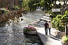
The River Walk, which meanders through the Downtown area, is the city's second-most-visited attraction, giving it the additional nickname of "River City". Extended an additional 13 miles between 2009 and 2013, the landscaped walking and bike path line the San Antonio River from the "Museum Reach" beginning in Brackenridge Park through downtown, "Downtown Reach", past the Blue Star's "Eagleland" to the "Mission Reach" ending near Loop 410 South past Mission Espada.[147]
Lined with numerous shops, bars, and restaurants, as well as the Arneson River Theater, this attraction is transformed into an impressive festival of lights during the Christmas and New Year holiday period (except for the Mission Reach), and is suffused with the local sounds of folklorico and flamenco music during the summer, particularly during celebrations such as the Fiesta Noche del Rio.
The Downtown area also features San Fernando Cathedral, The Majestic Theatre, Hemisfair (home of the Tower of the Americas, and UTSA's Institute of Texan Cultures), La Villita, Market Square, the Spanish Governor's Palace, and the historic Menger Hotel. The Fairmount Hotel, built in 1906 and San Antonio's second oldest hotel, is in the Guinness World Records as one of the heaviest buildings ever moved intact.[148] It was placed in its new location, three blocks south of the Alamo, over four days in 1985, and cost $650,000 to move.
The city is home to three animal attractions. SeaWorld, 16 miles (26 km) west of Downtown in the city's Westover Hills district, is the number 3 attraction and one of the largest marine life parks in the world. The very popular and historic San Antonio Zoo is in the city's Brackenridge Park. A third animal attraction was developed by British company Merlin Entertainments to accompany SeaWorld as a second aquarium attraction and indoor counterpart. The new attraction is inside the Shops at Rivercenter in Downtown San Antonio and is one of Merlin's Sea Life Aquariums. The San Antonio Aquarium is the third and final attraction.
San Antonio is also home to several commercial amusement parks, including Six Flags Fiesta Texas, Splashtown and Morgan's Wonderland, a theme park for children with special needs.[149] Kiddie Park, featuring old-fashioned amusement rides for children, was established in 1925 and is the oldest children's amusement park in the U.S.[150]

San Antonio is home to the first museum of modern art in Texas, the McNay Art Museum.[151][152] Other art institutions and museums include ArtPace, Blue Star Contemporary Art Center, the Briscoe Western Art Museum, Ruby City, Buckhorn Saloon & Museum (where visitors can experience something of cowboy culture year round), San Antonio Museum of Art, formerly the Lonestar Brewery, Say Sí (mentoring San Antonio artistic youth), the Southwest School of Art, Texas Rangers Museum, Texas Transportation Museum, the Witte Museum and the DoSeum. An outdoor display at North Star Mall features 40-foot (12 meters)-tall cowboy boots.
The city's five missions, the four in the San Antonio Missions National Historical Park plus The Alamo, were named UNESCO World Heritage sites on July 5, 2015.[21] The San Antonio Missions became the 23rd U.S. site on the World Heritage list, which includes the Grand Canyon and the Statue of Liberty; it is the first site in Texas. The new Mission Reach of the River Walk was completed in 2013, and created over 15 miles of biking, hiking, and paddling trails that connect the Missions to Downtown and the Broadway Corridor.[153]
Other places of interest include the San Antonio Botanical Garden, Brackenridge Park, the Japanese Tea Gardens, The Shops at La Cantera, the Sunken Garden Theater, The Woodlawn Theatre and the Majik Theatre, a children's educational theater.
In 2015 work was authorized to begin on the restoration of the former Hot Wells hotel, spa, and bathhouses on the San Antonio River on the city's south side.[154]
Sports[]
| Club | Sport | League | Founded | Venue (capacity) | Attendance | Titles | Championship years |
|---|---|---|---|---|---|---|---|
 UTSA Roadrunners |
American football | NCAA Division I | 2011 | Alamodome (65,000) | 27,576 | 0 | |
 San Antonio Spurs |
Basketball | NBA | 1967 | AT&T Center (18,580) | 18,418 | 5 | [o 1] |
 San Antonio Missions |
Baseball | Double-A Central | 1888 | Wolff Stadium (9,200) | 8,500 | 13 | [o 2] |
 San Antonio FC |
Soccer | USL Championship | 2016 | Toyota Field (8,300) | 6,765 | 0 |
Professional sports[]

The city's only top-level professional sports team, and consequently the team most San Antonians follow, is the San Antonio Spurs of the National Basketball Association. Previously, the Spurs played at the Alamodome (which was speculatively built in an attempt to lure a professional football team to the region), and before that the HemisFair Arena. They moved into the SBC Center in 2002 (since renamed the AT&T Center), built with public funds.
San Antonio is home to the Double-A San Antonio Missions, who play at Nelson Wolff Stadium and are the Minor League Baseball affiliate of the San Diego Padres.[155]
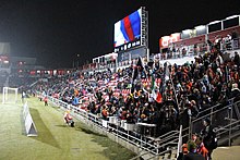
San Antonio had a professional soccer franchise when the San Antonio Thunder played two seasons in the original NASL during the 1975–1976 seasons. Professional soccer returned with the birth of the San Antonio Scorpions of the modern NASL in 2012. The Scorpions won the 2014 Soccer Bowl, the first soccer championship in city history. On December 22, 2015, it was announced that Toyota Field and S.T.A.R. Soccer Complex were sold to the City of San Antonio and Bexar County, a deal which was accompanied by an agreement for Spurs Sports and Entertainment to operate the facilities and field a team that plays in the United Soccer League. San Antonio FC began play in the soccer-specific stadium, Toyota Field, in 2016. As a result, the San Antonio Scorpions franchise of the NASL was shut down. San Antonio has two rugby union teams, the Alamo City Rugby Football Club, and San Antonio Rugby Football Club.
The San Antonio metropolitan area's smaller population has so far contributed to its lack of an NFL, MLB, NHL, or MLS team. City officials are said to be attempting to lure the National Football League permanently to San Antonio. Former NFL Commissioner Paul Tagliabue stated San Antonio was successful in temporarily hosting the New Orleans Saints following Hurricane Katrina, and that the city would be on the short list for any future NFL expansions.[156] The city has also hosted the Dallas Cowboys and Houston Oilers preseason camps in the past, and the Cowboys practiced in San Antonio through 2011.[157] Cowboys owner Jerry Jones acknowledged his support for the city to become home to an NFL franchise.[158]
The city has played host to a number of major and minor league football teams, primarily at Alamo Stadium and the Alamodome. The San Antonio Gunslingers of the United States Football League and the San Antonio Riders of the World League of American Football played for two seasons each in the 1980s and 1990s, respectively; while the San Antonio Wings of the World Football League and the San Antonio Texans of the Canadian Football League each played a single season. In 2018, the Alliance of American Football announced that the San Antonio Commanders would play in the city beginning in 2019.[159] The Commanders opened play at the Alamodome in February 2019. San Antonio was also home to the minor-league Toros of the Texas Football League (later the Continental Football League, then Trans-American Football League) from 1966 to 1971; and the minor-league Charros of the American Football Association from 1978 to 1981.
The Valero Texas Open is a professional golf tournament on the PGA Tour held at San Antonio since 1922. It has been played at TPC San Antonio since 2010. Previous venues include the Brackenridge Park Golf Course, La Cantera Golf Club and Pecan Valley Golf Club; the latter also hosted the 1968 PGA Championship. The Alamo Ladies Classic was an LPGA Tour event held from 1960 to 1973.
The first Rising Phoenix World Championships was held at Grand Hyatt, San Antonio in 2015.
The city used to be home to the San Antonio Stars until the franchise was relocated in October 2017 to Las Vegas to become the Las Vegas Aces.[160]
The city used to be home to the San Antonio Rampage until the franchise was sold in February 2020 to the Vegas Golden Knights.[161]
College sports[]

The University of Texas at San Antonio fields San Antonio's NCAA Division I athletic teams, known as the UTSA Roadrunners. The teams play in Conference USA. The university added football in 2011, hiring former University of Miami coach Larry Coker as its initial head coach. Roadrunner football began play in 2011, with a record of 4–6. UTSA set attendance records for both highest attendance at an inaugural game (56,743) and highest average attendance for a first year program (35,521).[162][163] The Roadrunners moved to the Western Athletic Conference in 2012, and to Conference USA in 2013. University of the Incarnate Word also fields a full slate of NCAA Division I athletic teams, known as the Incarnate Word Cardinals; however, their football team competes in the football championship subdivision in the Southland Conference.
Trinity University fields all the typical collegiate sports, but at the NCAA Division III level. Trinity competes in the Southern Collegiate Athletic Conference (SCAC). The Trinity baseball team won the 2016 Division III College World Series, one of six national team and 21 national individual championships won by the school's athletic program in the Division III era.[164] Prior to moving to Division III, Trinity was a national power in tennis, winning five USTA women's championships and one NCAA men's title between 1968 and 1976.[164] Chuck McKinley won the men's championship at Wimbledon and was a member of the winning Davis Cup team as a student at Trinity in 1963.[165]
San Antonio hosts the NCAA football Alamo Bowl each December, played among the Big XII and Pac-12 each December in the Alamodome. The city is also home of the U.S. Army All-American Bowl,[166] played annually in the Alamodome and televised live on NBC. The Bowl is an East versus West showdown featuring the nation's top 90 high school football senior players. The game has featured NFL stars Reggie Bush, Vince Young, Adrian Peterson, and many other college and NFL stars.
The University of Texas at San Antonio fields the only collegiate men's rugby team in the city. UTSA competes in Division III Texas Rugby Union.
Government[]
The city of San Antonio is operated under the council-manager system of government. The city is divided into 10 council districts designed to be of equal population. Each district elects one person to the city council, with the mayor elected on a citywide basis. All members of the San Antonio City Council, including the mayor, are elected to two-year terms and are limited to four terms (except for those who were in office in November 2008 and are limited to a total of two terms). Houston and Laredo have similar term limits to San Antonio. All positions are elected on nonpartisan ballots, as required by Texas law. Council members are paid $45,722 and the mayor earns $61,725 a year. The current mayor is Ron Nirenberg, who was elected in 2017 with 54.59% of the vote.[167] Nirenberg was narrowly reelected in 2019 against conservative challenger Greg Brockhouse.[168][169]
The council hires a city manager to handle day-to-day operations. The council effectively functions as the city's legislative body with the city manager acting as its chief executive, responsible for the management of day-to-day operations and execution of council legislation. The current city manager is Erik Walsh.
The city operates its own electric and gas utility, CPS Energy. The San Antonio Police Department (SAPD) is the city's municipal body of law enforcement. The San Antonio Fire Department (SAFD) provides the city with fire protection and EMS service.
The city stretches into several national congressional districts and is represented in Congress by:[170]
- Senate
- Ted Cruz (R)
- John Cornyn (R)
- House of Representatives
- Texas District 20: Joaquin Castro (D)
- Texas District 21: Charles E. "Chip" Roy (R)
- Texas District 23: Tony Gonzales (R)
- Texas District 28: Henry Cuellar (D)
- Texas District 35: Lloyd Doggett (D)
- State Governor
- Greg Abbott (R)
State and federal representation[]

The Texas Department of Criminal Justice (TDCJ) operates the Parole Division Region IV headquarters in the San Antonio Metro Parole Complex. San Antonio district parole offices I and III are in the parole complex, while office II is in another location.[171]
The Texas Department of Transportation operates the San Antonio District Office in San Antonio.[172]
The United States Postal Service operates San Antonio's main post office.[173] Other post offices are located throughout San Antonio.
Growth policy[]
Unlike most large cities in the U.S., San Antonio is not completely surrounded by independent suburban cities, and under Texas state law it exercises extraterritorial jurisdiction (ETJ) over much of the surrounding unincorporated land,[174][175] including planning major thoroughfares and enforcing rules for platting and subdivision. It pursues an aggressive annexation policy and opposes the creation of other municipalities within its ETJ.[176] Nearly three-fourths of its land area has been annexed since 1960.[177]
In the 2000s the city annexed several long narrow corridors along major thoroughfares in outlying areas to facilitate eventual annexation of growth developing along the routes. The city planned to annex nearly 40 additional square miles by 2009.[178]
In May 2010, the City of San Antonio agreed to release thousands of acres of land in its extraterritorial jurisdiction along Interstate 10 to Schertz. The agreement releases a total of 3,486 acres (14.11 km2) of San Antonio's ETJ lands north of I-10 to Schertz. The ETJ lands are in an area bordered by FM 1518 to the west, Lower Seguin Road to the north, Cibolo Creek to the east and I-10 to the south.[179]
Involuntary annexation is a controversial issue in those parts of unincorporated Bexar County affected by it. Residents attracted to the outlying areas by lower taxes and affordable real estate values often see annexation as a mechanism to increase property tax rates (which are primarily driven by school district taxes, not city taxes) without a corresponding improvement in services such as police and fire protection, while the city regards its annexation policy as essential to its overall prosperity.[180]
Since the city has annexed areas over time, San Antonio surrounds several independent enclave cities, including Alamo Heights, Balcones Heights, Castle Hills, Hill Country Village, Hollywood Park, Kirby, Leon Valley, Olmos Park, Shavano Park, Terrell Hills, and Windcrest. These are not districts of the city of San Antonio like Lincoln Heights and Brackenridge Park but independent cities in the San Antonio region completely surrounded, but not directly controlled, by the city of San Antonio.
Education[]
Higher education[]

San Antonio hosts over 100,000 students in its 31 higher-education institutions. Publicly supported schools include UT Health San Antonio, the University of Texas at San Antonio, Texas A&M University–San Antonio, and the Alamo Community College District. The University of Texas at San Antonio is San Antonio's largest university.

Private universities include Trinity University, St. Mary's University, Our Lady of the Lake University, University of the Incarnate Word, Webster University, Baptist University of the Américas, Hallmark University, Oblate School of Theology, and the Southwest School of Art, which enrolled its first BFA class in 2014.[181][182] The San Antonio Public Library serves all of these institutions along with the 19 independent school districts within the Bexar County and Greater San Antonio metropolitan area.[183] San Antonio is also home to a campus of The Culinary Institute of America.[184]
Secondary and primary education[]
The city is home to more than 30 private schools and charter schools. These schools include: Keystone School, St. Gerard Catholic High School, Central Catholic Marianist High School, Incarnate Word High School, Saint Mary's Hall, The Atonement Academy, Antonian College Preparatory High School, San Antonio Academy, Holy Cross High School, Providence High School, The Carver Academy, Keystone School, TMI – The Episcopal School of Texas, St. Anthony Catholic High School, Lutheran High School of San Antonio, and Harmony Science Academy (School of Science and Technology).
The city of San Antonio and Bexar County are also served by the following 17 separate independent school districts (ISDs) which each encompass elementary, middle, and high schools:
- Alamo Heights
- East Central
- Edgewood
- Fort Sam Houston
- Harlandale
- Judson
- Lackland
- Medina Valley
- North East
- Northside
- Randolph Field
- San Antonio
- Schertz-Cibolo-Universal City
- South San Antonio
- Southside
- Southwest
- Somerset
Military[]
San Antonio is home to U.S. Air Force Basic Military Training (AFBMT).[185] The Air Force only has one location for enlisted basic training: the 737th Training Group, at Lackland Air Force Base. All new Air Force recruits go through the same basic training at Lackland. Each year, over 35,000 new recruits go through AFBMT. In addition, METC (the Military Education and Training Campus), which provides the medical training for the U.S. military at Fort Sam Houston, hosts 30 programs and over 24,000 annual graduates. It is the largest medical education center in the world.
Media and entertainment[]
Print[]

San Antonio has one major newspaper, the San Antonio Express-News, which has served the area since 1865. The Express-News circulates as the largest newspaper service in South Texas. The Hearst Corporation, which owned a second newspaper, the San Antonio Light, purchased the Express-News from News Corp. in 1992 and shut down the Light after failing to find a buyer.
Hearst, using the Express-News brand, also produces Conexión, a weekly magazine written by an entirely Hispanic and Latin American staff with a Latino spin on weekly events. The San Antonio Current is the free "alternative" paper published weekly with local political issues, art and music news, restaurant listings and reviews, and listings of events and nightlife around town. The San Antonio Business Journal covers general business news. La Prensa, a bilingual publication, also has a long history in San Antonio. They closed their doors in June 2018.[186] Edible San Antonio, San Antonio's bimonthly food magazine, is published every eight weeks. The 64-page full-color magazine, distributed free across the city, is printed in soy ink on recycled paper and covers the city's food scene with an emphasis on local food and sustainability. The San Antonio River Walk Current covers general San Antonio news. The San Antonio Observer is the only African American newspaper in San Antonio since 1995 and the largest in all of South Texas.
The San Antonio Report, renamed in 2020 from the Rivard Report, is the city's only digital-only news publication. Founded in 2011 by former Express-News' editor Robert Rivard, it began as a blog but has since become a non-profit news source covering civic issues.
Radio[]
About 50 radio stations can be heard in the San Antonio area; 30 of them are in the city proper. San Antonio is home to iHeartMedia, the largest operator of radio stations in the U.S. Its flagship, WOAI AM-1200, is known for its local news operation, considered among the best in the country. It is a 50,000-watt clear channel station that reaches most of North America at night. The first radio station to broadcast in South Texas was KTSA AM-550 in 1922.
The region's National Public Radio member is Texas Public Radio,[187] a group of three stations; KSTX 89.1 FM is NPR news/talk, KPAC 88.3 is a 24-hour classical music station, and KTXI 90.1 is a mix of NPR news/talk and classical music broadcast for the West Central Texas Hill Country. KSTX also broadcasts "Riverwalk Jazz", featuring Jim Cullum Jazz Band at The Landing, a fixture on the River Walk since 1963.
KRTU 91.7 is a non-commercial radio station based at Trinity University.[188] Unlike most other college radio stations in the U.S., the station plays jazz 17 hours a day and college rock/indie rock at night. College alternative station KSYM, 90.1 FM, is owned by the Alamo Community College District and operated by San Antonio College students; like KRTU, it plays the Third Coast music network during the day and alternative music at night.
Most Latin American stations in the area play regional Mexican, Tejano or contemporary pop. On January 12, 2006, Univision-owned KCOR-FM "La Kalle 95.1" changed its format from Hispanic-Rhythmic Contemporary Hits to Spanish Oldies, then named "Recuerdo 95.1". On November 10, 2006, Univision flipped KLTO Tejano 97.7's format to reggaeton in an attempt to reintroduce the format to San Antonio. Then 97.7 was flipped again to feature a rock format. The station no longer broadcasts anything in English. While still owned by Univision, it broadcast music by artists such as Linkin Park, before being sold to the Educational Media Foundation and flipping once again to Air1.
95.1 was then flipped back to the "La Kalle" format again after being flipped to feature a "95X" format. KLTO was acquired and is operated as a simulcast of KXTN-FM Tejano 107.5. San Antonio radio is diversified, due to an influx of non-Tejano Latinos, mostly from the East Coast, who serve in the city's various military bases, as well as immigrants from Mexico. Therefore, just like in the rest of the country, radio station conglomerates have been changing formats in San Antonio to reflect shifting demographics.
Television[]

Despite the relatively large size of both the city proper and the metropolitan area, San Antonio has always been a medium-sized market. It presently ranks 33rd in the United States, according to marketing research firm ACNielsen.[189] By comparison, the other two Texas cities with populations of over a million people, Houston and Dallas, are among the 10 largest markets. This is mainly because the nearby suburban and rural areas are not much larger than the city itself. Additionally, the close proximity of Austin truncates the potential market area.
San Antonio-based television stations include KCWX channel 2 (myNetworkTV), WOAI channel 4 (NBC/CW), KENS channel 5 (CBS), KLRN channel 9 (PBS), KSAT channel 12 (ABC), KNIC-DT channel 17 (UniMás), KABB channel 29 (FOX), KVDF-CD channel 31 (Azteca América), KMYS channel 35 (Dabl), KWEX-DT channel 41 (Univision) and KVDA channel 60 (Telemundo). The market is also home to three religious stations, three independent stations and one Internet-based station (210 TV[190]). As of 2010, the San Antonio market has 65% cable TV penetration.
Annual events[]
Yearly events, such as Fiesta San Antonio (the city's signature event), Luminaria (a contemporary arts festival) and Fiesta Noche del Rio, add a variety of entertainment options to the area, as well as strengthening the economy. Fiesta San Antonio alone carries an annual economic impact of $340 million.[191] The city also plays host to SAFILM-San Antonio Film Festival every summer in August.[192] About to celebrate 25 years, the film festival is the largest in South Texas.
Transportation[]
Air[]
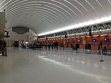
The San Antonio International Airport (SAT) is located in uptown San Antonio, about eight miles north of Downtown. San Antonio International Airport is the 6th busiest airport based on passenger boardings in Texas and 44th in the United States as of 2015.[193] It has two terminals and is served by 18 airlines, 14 passenger and 4 cargo ones, serving many destinations. In May 2017, Air Canada opened its reach to Texas creating a non-stop flight between San Antonio and Toronto. Stinson Municipal Airport is a reliever airport located six miles (10 km) south of Downtown San Antonio. The airport has three runways and is also home to the Texas Air Museum.
Mass transit[]

A bus and rubber tired streetcar (bus) system is provided by the city's metropolitan transit authority, VIA Metropolitan Transit. VIA's full fare monthly unlimited Big Pass is $38 per month. VIA began operating a bus rapid transit line known as VIA Primo[194] in December 2012, which connects Downtown San Antonio to the South Texas Medical Center, the main campus of the University of Texas at San Antonio, and the independent enclave city of Leon Valley. Additionally, VIA also offers VIAtrans Paratransit Service,[195] a wheelchair accessible ride-share service for people with disabilities.
In August 2010, VIA Metropolitan Transit unveiled buses that are powered by diesel-electric hybrid technology.[196] The 30 hybrid buses were put into service on VIA's express routes to serve daily commuters across the city. This set of buses follows the introduction of new vehicles powered by compressed natural gas, which were unveiled in May 2010. In the fall of 2010, VIA took delivery of three new buses that are powered by electricity from on-board batteries. These buses serve the Downtown core area, and are the first revenue vehicles VIA operates which have zero emissions.[196]
VIA offers 90 regular bus routes and two Downtown streetcar routes.[197] This includes express service from Downtown to park and ride locations in the south, west, northwest, north central and northeast sides of the city, with service to major locations such as UTSA, Six Flags Fiesta Texas and SeaWorld. VIA also offers a special service to city events including Spurs games and city parades from its park and ride locations.
Rail[]
San Antonio is served by two Amtrak routes: the daily Chicago to San Antonio Texas Eagle and the thrice-weekly New Orleans to Los Angeles Sunset Limited.[198] On the days that the Sunset Limited operates, a section of the Texas Eagle continues west with it, offering Chicago to Los Angeles through service. The old Sunset Station is now an entertainment venue owned by VIA and neighbored by the current station and the Alamodome.[199]
Freight service from San Antonio to Corpus Christi is provided by the Union Pacific Railroad. The predecessor route, including passenger service, from 1913 to 1956 was provided by the , or "The Sausage", as it was commonly termed. The SAU&G was merged into the Missouri Pacific Railroad in 1956 and subsequently subsumed by the Union Pacific.[200][201]
San Antonio became the largest American city without an intra-city rail system when Phoenix, the former largest city without such a system, procured one in 2008. A proposed passenger rail line, Lone Star Rail, would have linked San Antonio to Austin, but was cancelled in 2016 after 19 years of planning.[202]
Road[]
San Antonio is served by these major freeways:
- Interstate 10: McDermott Freeway (Northwest) runs west toward El Paso, Phoenix and Los Angeles. Jose Lopez Freeway (East) runs east toward Seguin, Houston, New Orleans and Jacksonville
- Interstate 35: Pan Am Expressway (Northeast/Southwest)—runs south toward its southern terminus Laredo and runs north toward Austin, Dallas–Fort Worth, Oklahoma City, Kansas City, Des Moines, Minneapolis-St. Paul, and finally to its northern terminus in Duluth.
- Interstate 37: Lucian Adams Freeway (Southeast)—runs from San Antonio through its junction with US Highway 281 south (Edinburg and McAllen) near Three Rivers and into Corpus Christi through its junction with Interstate 69E/US Highway 77 south (Kingsville, Harlingen and Brownsville) to its southern terminus at Corpus Christi Bay.
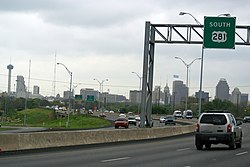
- Interstate 410: Connally Loop—simply called Loop 410 (four-ten) by locals is a 53-mile (85 km) inner beltway around the city.
- US 90: Cleto Rodriguez Freeway (West) through Uvalde and Del Rio to its western terminus at I-10 in Van Horn. Prior to I-10 East and US 90 West expressway being built US 90 traveled through the west side via West Commerce St. (westbound) and Buena Vista St. (eastbound) and Enrique M. Barrera Pkwy. On the east side it traveled along East Commerce St. to its current alignment which runs concurrent with I-10 East to Seguin.
- US 281: McAllister Freeway (North) to Johnson City and Wichita Falls. Southbound, it runs concurrent with I-37, then I-410 for 4 miles (6 km), then heads south to Pleasanton. Prior to I-37 and McAllister Fwy. being built US 281 traveled through the north side via San Pedro Ave. and the south side via Roosevelt Ave.
- State Highway 151: Stotzer Freeway runs from US Hwy 90 West through Westover Hills which includes SeaWorld to its western terminus at State Loop 1604.
- State Loop 1604: Charles W. Anderson Loop—simply called 1604 (sixteen-oh-four) by locals—is a 96-mile (154 km) outer beltway around San Antonio.
Other highways include:
- US 87: Southbound to Victoria along Roland Avenue then Rigsby Avenue. It runs concurrent with I-10 for 52 miles (84 km) where it goes to San Angelo northbound.
- US 181: Starts 0.5 miles (0.8 km) south of I-410/I-37/US 281 interchange and heads toward Corpus Christi via Beeville. Prior to I-37 being built, US 181 traveled along Presa St. from Downtown to its current alignment.
- State Highway 16: From Freer, it runs concurrent with I-410 for 17 miles (27 km) along southwest San Antonio, over to Bandera Road to Bandera
- State Highway 130: Starting at its southern terminus at I-35 South, it travels along East S Loop 410 until I-10/US-90, where it runs concurrently with the interstate until outside of Seguin, turning into a state toll road.
- State Highway Spur 421: Also known more commonly as "Culebra Rd." and "Bandera Rd." inside Loop 410.
- State Highway Spur 422: Known as the Poteet Jourdanton Freeway. It was originally planned to have a high speed direct connection to I-35.
- State Loop 345: Fredericksburg Road by locals; is the business loop for I-10 West/US-87 North.[203]
- State Loop 368: Broadway and Austin Highway by locals; is the business loop for I-35 North.[204]
- State PA 1502 (Wurzbach Parkway): Limited-access, high speed road parallel to north IH-410. It has connections to I-35 (via O'Connor Rd.) and I-10 (via Wurzbach Rd.) across the north side of town.
- State Loop 353: Nogalitos Street and New Laredo Highway is the business loop for I-35 South.[205]
- State Loop 13: Is the city's inner loop on the south side serving Lackland AFB, Port San Antonio, South Park Mall and Brooks CityBase traveling along Military Dr. on the south side and WW White Rd. on the east side to its junction with I-35/I-410. The northern arc of the loop is now I-410.
Along with FM 471, FM 1957, and State Highway 211
Also, the city has multiple streets with the same (or similar) names. As examples:
- "Military Dr.", "Military Hwy.", and "Military Dr. West"—Military Drive loops around the western and southern parts of the city. Military Highway, also called "Northwest Military Drive" by the locals, serves the northwestern part of the city. Military Drive West serves the far western portion of the city. None intersect each other.
- "Wurzbach Rd.", "Wurzbach Pkwy.", and "Harry Wurzbach Rd."—Wurzbach Rd. serves the northwestern part of the city. Wurzbach Pkwy., an expressway, is an east–west road serving the northwestern and northeastern parts of the city (and can be considered an extension of Wurzbach Rd.). Harry Wurzbach Rd. runs past Fort Sam Houston and Terrell Hills on the city's northeast side, and it does not intersect Wurzbach Rd. or Wurzbach Pkwy.
- "Hausman Rd." and "S. Hausman Rd." are two roads serving Helotes and the far northwest side of the city. Hausman is a major road, and a route used by locals of Helotes and NW San Antonio as an alternative to Loop 1604 connecting to I-10. S. Hausman is a suburban road that does not connect with Hausman (despite its name).
Of the five largest cities in Texas, San Antonio is the only one without toll roads. (Houston, Dallas, Austin, and Fort Worth have toll roads.)
Bicycle paths[]
San Antonio has about 136 miles (219 km) of bike lanes, routes or off-road paths.[206] Off-road trails travel along the San Antonio River, linear greenways, or city parks. Although largely disconnected, the progress to create a bicycle-friendly environment was recognized when San Antonio was designated a bronze-level "Bicycle Friendly Community" in 2015 by the League of American Bicyclists.[207]
Bicycle sharing[]
A bike sharing service was approved by the city council on June 17, 2010.[208] The initial program consisted of 140 bikes at 14 locations supported by a "central hub". It is expected to serve both residents and visitors. San Antonio Bike Share, a non-profit, was formed to oversee the operation, locally operated and maintained by Bike World. B-Cycle, the same system used in Denver, supplies the bike share system. It began operation in March 2011.[209]
Walkability[]
San Antonio is one of the most car-dependent major cities in the United States.[210]
In popular culture[]
Movies predominantly filmed in San Antonio includes The Immortal Alamo (1911), The Warrens of Virginia (1924), Wings (1927), West Point of the Air (1935), High School (1940), I Wanted Wings (1941), Air Cadet (1951),Viva Max! (1969), The Getaway (1972), Sugarland Express (1974), Race with the Devil (1975), The Great Waldo Pepper (1975), Rolling Thunder (1977), Honeysuckle Rose (1980), Cloak and Dagger (1984), Pee Wee's Big Adventure (1985), My Two Loves (1986), Nadine (1987), Johnny B Goode (1988), Lost Angels (1989), Knight Rider 2000 (1991), Toy Soldiers (1991), Father Hood (1993), 8 Seconds (1994), Blank Check (1994), Ace Ventura: When Nature Calls (1995), Selena- biopic of the same name (1997), The Newton Boys (1998), Miss Congeniality (2000), All the Pretty Horses (2000), Waking life (2001) and Spy Kids (2001) along with Spy Kids 2 (2002), including Stop-Loss (2008), From Mexico with Love (2009), and The Walking Deceased (2015).[211] The 2014–2017 NBC television series The Night Shift took place in San Antonio, with its themes focusing on the city's medical and military presence.[212]
International relations[]
Sister cities[]

San Antonio is twinned with:
 – Monterrey, Nuevo León, Mexico (1953)[213]
- – Guadalajara, Jalisco, Mexico (1974)[213][214]
 – Las Palmas de Gran Canaria, Canary Islands, Spain (1975)[213]
 – Gwangju, South Korea (1981)[213][215]
 – Kaohsiung, Taiwan (1981)[213]
- – Santa Cruz de Tenerife, Canary Islands, Spain (1983)[213]
 – Kumamoto, Japan (1987)[213]
 – Chennai, India (2008)[213][216]
 – Wuxi, China (2012)[213]
 – Windhoek, Namibia (2016)[217]
 – Darmstadt, Hesse, Germany (2017)[218]
- – Moguer, Spain (2018). Hometown of the founder Father Antonio de Olivares.[219]
Friendship cities[]
- – Suzhou, China (2010 friendship city)[213][220]
 – Tel Aviv-Yafo, Israel (2011 friendship city)[221]
See also[]
- List of people from San Antonio
- National Register of Historic Places listings in Bexar County, Texas
- San Antonio Area Foundation
Notes[]
- ^ Mean monthly maxima and minima (i.e. the highest and lowest temperature readings during an entire month or year) calculated based on data at said location from 1991 to 2020.
- ^ Official records for San Antonio were kept at downtown from March 1885 to December 1940, at Stinson Municipal Airport from January 1941 to June 1942, and at San Antonio Int'l since July 1942. For more information, see Threadex
References[]
- ^ Austin Papers: Series III, 1835 (December 9, 1835). "Transcript of letter from E. Hall to James F. Perry". Retrieved June 16, 2021 – via University of North Texas Libraries, The Portal to Texas History.
- ^ Olmsted, Frederick Law (1857). Journey through Texas, or, A saddle-trip on the southwestern frontier : with a statistical appendix. New York: Dix, Edwards & Co. p. 187. Retrieved June 16, 2021 – via University of North Texas Libraries, The Portal to Texas History.
- ^ Marini, Richard A. (March 21, 2012). "You know you're from San Antonio if ..." San Antonio Express-News. Retrieved June 17, 2021.
- ^ Ayala, Christine (May 6, 2016). "No, Obama, it's not called 'San Antone". Dallas Morning News. Retrieved June 16, 2021.
- ^ a b c Adina Emilia De Zavala (December 8, 1917). "History and Legends of The Alamo and Other Missions In and Around San Antonio". History legends of de Zarichs Online. p. 8. Retrieved June 2, 2014.
- ^ "LC Linked Data Service: Authorities and Vocabularies (Library of Congress)". id.loc.gov.
- ^ "2019 U.S. Gazetteer Files". United States Census Bureau. Retrieved August 7, 2020.
- ^ "2020 Population and Housing State Data". United States Census Bureau. Retrieved August 22, 2021.
- ^ "San Antonio Was The First Southern City to integrate lunch counters".
- ^ a b "QuickFacts: San Antonio city, Texas". United States Census Bureau. Retrieved August 20, 2021.
- ^ San Fernando de Bexar Archived September 4, 2019, at the Wayback Machine. Chabot, Frederick Charles. Texas State Historical Association. Uploaded 15 June 2010. Retrieved 17 September 2017.
- ^ "The First Civil Settlement in Texas Archived July 9, 2019, at the Wayback Machine". Guerra, Mary Ann Noonan. Excerpted from The San Antonio River (The Alamo Press, San Antonio: 1987). Retrieved 17 September 2017.
- ^ 300, San Antonio. "SA300 Tricentennial - Celebrating San Antonio for 300 Years". sanantonio300.org. Archived from the original on July 11, 2019. Retrieved July 11, 2019.CS1 maint: numeric names: authors list (link)
- ^ "Population Distribution and Change 2000 to 2010". 2010 United States Census. Retrieved June 1, 2012.
- ^ "Incorporated Places of 100,000 or More Ranked by Numeric Population Change: 1990 to 2000". United States Census 2000. Retrieved June 1, 2012.
- ^ a b Bureau, U.S. Census. "U.S. Census website". United States Census Bureau. Retrieved July 9, 2018.
- ^ "SLOWED, BUT NOT STOPPED: Austin, San Antonio and areas between to become a metroplex". www.bizjournals.com. Retrieved December 14, 2020.
- ^ a b Kotkin, Joel. "America's Next Great Metropolis Is Taking Shape In Texas". Forbes. Retrieved July 10, 2018.
- ^ a b "St. Anthony of Padua - Saints & Angels". Catholic Online. Retrieved December 14, 2020.
- ^ "Saint Anthony of Padua | Franciscan Media". www.franciscanmedia.org. Retrieved December 14, 2020.
- ^ a b c Mach, Andrew (July 5, 2015). "San Antonio Missions among new UNESCO World Heritage Sites". PBS. Retrieved October 29, 2016.
- ^ "Joint Base San Antonio". www.jbsa.mil. Retrieved December 14, 2020.
- ^ "SA Bases". www.sanantonio.gov. Retrieved December 14, 2020.
- ^ a b "18 Things You Didn't Know About Military City USA". www.kwsanantonio.com. Retrieved December 14, 2020.
- ^ "P2: HISPANIC OR LATINO, AND NOT HISPANIC OR LATINO BY RACE". 2020 Census. United States Census Bureau. Retrieved October 10, 2021.
- ^ "San Antonio: The City of St. Anthony". St. Anthony Messenger Magazine Online. Americancatholic.org. June 2004. Retrieved June 30, 2010.
- ^ a b [1] Spanish Texas, Texas State Historical Society: The Handbook of Texas Online
- ^ Chipman, Donald E. "Martin de Alarcon". Handbook of Texas. Texas State Historical Society. Retrieved June 23, 2021.
- ^ a b [2] Archived September 4, 2019, at the Wayback Machine The Canary Islanders, Texas State Historical Society: The Handbook of Texas Online
- ^ John H. Jenkins, ed., Papers of the Texas Revolution (10 vols.; Austin: Presidial Press, 973), p.13
- ^ a b John H. Jenkins, ed., Papers of the Texas Revolution (10 vols.; Austin: Presidial Press, 973), p. 13
- ^ Gonzalez, Juan. Harvest of Empire. Penguin, 2000.
- ^ Fisher, Lewis F. (1996). Saving San Antonio: the precarious preservation of a heritage. Lubbock: Texas Tech University Press.
- ^ A Journey Through Texas, by Frederick Olmsted ISBN 978-1-144-80380-1
- ^ Frederick Law Olmsted, A Journey through Texas; or, A Saddle-trip on the South-western Frontier: with a statistical appendix (1859), on-line text at Internet Archive
- ^ "German Heritage".
- ^ Saving San Antonio by Lewis F. Fisher ISBN 978-0-89672-372-6
- ^ "POPULATION DISTRIBUTION IN 2005" (PDF). United States Census Bureau. Retrieved June 10, 2017.
- ^ a b c d "Texas – Race and Hispanic Origin for Selected Cities and Other Places: Earliest Census to 1990". U.S. Census Bureau. Archived from the original on August 12, 2012. Retrieved April 21, 2012.
- ^ Kotkin, Joel (January 16, 2015). "The cities where African Americans are doing the best economically". Forbes. Retrieved January 16, 2015.
- ^ {{Cite web|date=2021-8-13|title=Latinos, Blacks Show Strong Growth in San Antonio as White Population Declines|url=https://www.expressnews.com/news/local/article/Latinos-Black-communities-grow-in-San-Antonio-16385595.php
- ^ Alan, Gomez (September 23, 2018). "Local governments spend millions caring for migrants dumped by Trump's Border Patrol". USA Today. Retrieved September 24, 2019.
- ^ Nowlin, Sanford. "San Antonio and Bexar County Impose Shelter-in-Place Order Through April 9 to Contain Coronavirus Spread". San Antonio Current. Retrieved June 24, 2020.
- ^ "Governor Abbott Announces Phase One To Open Texas, Establishes Statewide Minimum Standard Health Protocols". gov.texas.gov. Retrieved June 24, 2020.
- ^ Sabawi, Fares (June 17, 2020). "New Bexar County executive order mandates face coverings at all businesses when social distancing is not possible". KSAT. Retrieved June 24, 2020.
- ^ "Governor Abbott Issues Executive Order Providing Clarity And Uniformity In The State's COVID-19 Response". gov.texas.gov. Retrieved September 6, 2021.
- ^ "Texas Supreme Court Sides with Paxton Regarding Ban on Mask Mandates". www.texasattorneygeneral.gov. Retrieved September 6, 2021.
- ^ [3] Archived March 28, 2009, at the Wayback Machine
- ^ "Geographic coordinates of San Antonio. Latitude, longitude, and elevation above sea level of San Antonio, Texas, USA". dateandtime.info. Retrieved December 14, 2020.
- ^ Beneby, Doyle (October 14, 2013). "Energy, Future of Texas Linked to Water". San Antonio Report. Retrieved December 14, 2020.
- ^ "The Value of U.S. Downtowns and Center Cities" (PDF). centrosanantonio.org. p. 18. Retrieved December 13, 2020.[permanent dead link]
- ^ "Maps show racial diversity of San Antonio-area neighborhoods". mySA. February 6, 2018. Retrieved December 14, 2020.
- ^ "How the Eastside Became Home to San Antonio's Black Community". San Antonio Report. January 15, 2018. Retrieved December 14, 2020.
- ^ "West Side braces for San Antonio's latest wave of gentrification". ExpressNews.com. May 9, 2019. Retrieved December 14, 2020.
- ^ "The Roles of Geography and Climate in Forecasting Weather in South Texas". Theweatherprediction.com. Retrieved March 6, 2013.
- ^ [4] Archived December 12, 2011, at the Wayback Machine
- ^ "Climatemapusa2.PNG file- Wikimedia Commons". Commons.wikimedia.org. February 11, 2008. Retrieved March 6, 2013.
- ^ "San Antonio Texas USDA Plant Hardiness Zone Map". plantmaps.com plantmaps. Retrieved October 7, 2019.
- ^ "December 2017 Snow Event". www.weather.gov. Retrieved April 27, 2019.
- ^ "San Antonio Suffers Worst Snowfall". Schenectady, New York. United Press International. January 12, 1985.
- ^ "Record Snow Buries San Antonio". Associated Press. The Philadelphia Inquirer. p. A3.
- ^ "San Antonio Flooding - Updated November, 2020".
- ^ "South Central Texas June 30-July 7, 2002". Flood Safety Education Project.
- ^ "Tornado rakes S.A. neighborhood". Mysanantonio.com. October 10, 2011. Retrieved July 12, 2018.
- ^ "San Antonio, Bexar County, TX Tornadoes". www.homefacts.com.
- ^ a b "San Antonio Climate Summary" (PDF). National Weather Service. Retrieved August 19, 2010.
- ^ "MONTHLY/ANNUAL/AVERAGE PRECIPITATION SAN ANTONIO, TX (1871–2010)" (PDF). National Weather Service. Retrieved June 3, 2012.
- ^ "NowData - NOAA Online Weather Data". National Oceanic and Atmospheric Administration. Retrieved May 31, 2021.
- ^ "Station Name: TX SAN ANTONIO INTL AP". U.S. Climate Normals 2020: U.S. Monthly Climate Normals (1991-2020). National Oceanic & Atmospheric Administration. Retrieved May 31, 2021.
- ^ "WMO Climate Normals for SAN ANTONIO/INTL, TX 1961–1990". National Oceanic and Atmospheric Administration. Retrieved July 19, 2020.
- ^ "San Antonio, Texas, USA - Monthly weather forecast and Climate data". Weather Atlas. Retrieved March 11, 2019.
- ^ a b "San Antonio (city), Texas". State & County QuickFacts. U.S. Census Bureau. Retrieved August 5, 2017.
- ^ "Annual Estimates of the Resident Population for Incorporated Places of 50,000 or More, Ranked by July 1, 2019 Population: April 1, 2010 to July 1, 2019". United States Census Bureau, Population Division. Retrieved May 21, 2020.
- ^ a b "2019 ACS Demographic and Housing Estimates Program". data.census.gov. Retrieved December 14, 2020.
- ^ Census 2000: Incorporated Places of 100,000 or More, Ranked by Population, U.S. Census Bureau.
- ^ a b Census 2000: Metropolitan Areas Ranked by Population, U.S. Census Bureau.
- ^ [5], U.S. Census Bureau.[dead link]
- ^ "Austin-San Antonio corridor is one of the nation's best for this hot job sector". CultureMap Austin. Retrieved July 10, 2018.
- ^ "2019 ACS Households and Families Estimates". data.census.gov. Retrieved December 14, 2020.
- ^ "2019 ACS Selected Social Characteristic Estimates". data.census.gov. Retrieved December 14, 2020.
- ^ American FactFinder, United States Census Bureau. "San Antonio city, Texas - ACS Demographic and Housing Estimates: 2006–2008". Factfinder.census.gov. Archived from the original on February 11, 2020. Retrieved June 30, 2010.
- ^ "2019 ACS Financial Income Annual Estimates". data.census.gov. Retrieved December 14, 2020.
- ^ "2019 ACS Poverty Status Estimates". data.census.gov. Retrieved December 14, 2020.
- ^ "San Antonio Poverty Rate Tops List Of Large Metro Areas". TPR. September 27, 2019. Retrieved December 14, 2020.
- ^ Wang, Jackie (September 17, 2020). "Census Bureau: San Antonio still poorest major U.S. metro but poverty rate declines". San Antonio Report. Retrieved December 14, 2020.
- ^ "Census Data: San Antonio Region's Poverty Rate Rises, Tops Nation". San Antonio Report. September 26, 2019. Retrieved December 14, 2020.
- ^ "Study: 4% of SA population is LGBT". Out in SA. March 23, 2015. Retrieved December 23, 2020.
- ^ "San Antonio a gay-friendly city in Texas". kens5.com. Retrieved December 23, 2020.
- ^ "Keeping the Faith". San Antonio Magazine. November 21, 2012. Retrieved December 14, 2020.
- ^ a b c "Religion in San Antonio, TX". bestplaces.net. Retrieved August 1, 2018.
- ^ "Religion in Early Texas | Texas Almanac". texasalmanac.com. November 29, 2017. Retrieved December 14, 2020.
- ^ "TSHA | San Antonio, Catholic Archdiocese Of". www.tshaonline.org. Retrieved December 14, 2020.
- ^ "Texas Baptists - Churches". texasbaptists.org. Retrieved December 14, 2020.
- ^ Agency, Mere. "SBC Churches Directory". churches.sbc.net. Retrieved December 14, 2020.
- ^ "Churches – Cooperative Baptist Fellowship". Retrieved December 14, 2020.
- ^ "Search - Find A Church". The United Methodist Church. Retrieved December 14, 2020.
- ^ "St. Sophia Greek Orthodox Church". stsophiagoc.org. Archived from the original on November 9, 2020. Retrieved December 14, 2020.
- ^ "Antiochian Orthodox Christian Archdiocese". ww1.antiochian.org. Retrieved December 14, 2020.
- ^ "Parishes - St. Anthony the Great Church". www.oca.org. Retrieved December 14, 2020.
- ^ "Home". www.stsjoachimandannaorthodox.org. Retrieved December 14, 2020.
- ^ "Find a Church". Episcopal Church. Retrieved December 14, 2020.
- ^ "Find a Congregation". The Anglican Church in North America. Retrieved December 14, 2020.
- ^ "Faith Takes A Stand In San Antonio". Retrieved August 29, 2018.
- ^ "San Antonio, TX United States". OU Communities. Retrieved December 14, 2020.
- ^ Malik, Alia (December 13, 2017). "Jewish community helped build San Antonio". ExpressNews.com. Retrieved December 14, 2020.
- ^ "Who We Are - Temple Beth-El | San Antonio". Temple Beth-El. Retrieved December 14, 2020.
- ^ Torralva, Krista (December 25, 2019). "Jewish congregation, in midst of Hanukkah, delivers meals to first responders working Christmas Day". ExpressNews.com. Retrieved December 14, 2020.
- ^ 7 Texas Cities are in Top 20 in Murder per Capita; New York Times online; accessed April 2017
- ^ "Drive-by City;" Remembering San Antoinio Gang Violence in the 1990s; SA Current; online; retrieved April 2017
- ^ Once Again Homicide Records Fall in Many Big Cities; Associated Press News Archive online; accessed April 2017
- ^ San Antonio Records 151 Homicides in 2016; Most in 2 Decades; CBS Local news, online; accessed April 2017
- ^ Homicides Hit a 21 Year High; Why?; My San Antonio online; accessed April 2017
- ^ Salinas, Rebecca (August 6, 2020). "Report: San Antonio ranks 4th among U.S. cities with biggest increase in homicide rates in 2020". KSAT. Retrieved December 14, 2020.
- ^ Hilsenrath, Jon (August 2, 2020). "Homicide Spike Hits Most Large U.S. Cities". Wall Street Journal. ISSN 0099-9660. Retrieved December 14, 2020.
- ^ "U.S. metro areas: Real Gross Domestic Product (GDP) 2018". Statista. Retrieved December 14, 2020.
- ^ "Auto industry recruiters pitch the San Antonio region". Automotive News. December 9, 2019. Retrieved December 14, 2020.
- ^ Mendoza-Moyers, Diego (October 15, 2020). "U.S. auto industry, San Antonio automakers bounce back from pandemic". mySA. Retrieved December 14, 2020.
- ^ "Report: San Antonio's tech workforce small but growing". ExpressNews.com. July 18, 2019. Retrieved December 14, 2020.
- ^ "Who We Are". South Texas Medical Center. Retrieved December 14, 2020.
- ^ San Antonio Tourism, SanAntonioRiverwalk.com. Retrieved January 7, 2007.
- ^ "The Economic Impact of San Antonio's Hospitality Industry" (PDF). Sanantoniotourism.com. Archived from the original (PDF) on October 11, 2017. Retrieved July 12, 2018.
- ^ "Fortune 500". Fortune. Retrieved December 13, 2020.
- ^ "America's Largest Private Companies". Forbes.com. August 1, 2017. Retrieved August 1, 2017.
- ^ "Hulu's new San Antonio office opens". www.bizjournals.com. Retrieved December 23, 2020.
- ^ "Hulu opens Viewer Experience Operations headquarters in San Antonio". KABB. November 28, 2017. Retrieved December 23, 2020.
- ^ "OCI moves headquarters from downtown San Antonio to Brooks (mySA)". Brooks. June 19, 2017. Retrieved December 23, 2020.
- ^ "CGI OPENS CENTER OF EXCELLENCE IN SAN ANTONIO | CGI.com". www.cgi.com. Retrieved December 23, 2020.
- ^ "(PRN) CGI opens center of excellence in San Antonio". Chron. March 20, 2007. Retrieved December 23, 2020.
- ^ Kronsbein (January 6, 2014). "Kaco opens a new plant in the U.S." Sun & Wind Energy. Retrieved December 23, 2020.
- ^ Natividad, Ivan. "KACO New Energy moving to Texas". www.theunion.com. Retrieved December 23, 2020.
- ^ Druzin, Rye (October 1, 2018). "Andeavor ceases to exist as Marathon completes purchase". mySA. Retrieved December 23, 2020.
- ^ "Silver Spring Networks Opens New San Antonio Office as CPS Energy Smart Grid Deployment Ramps Up". www.businesswire.com. November 7, 2014. Retrieved December 23, 2020.
- ^ "The Smart Grid is coming to San Antonio". CPS Energy Newsroom. November 6, 2013. Retrieved December 23, 2020.
- ^ "Toyota, Navistar moves 'a huge boost' to San Antonio's advanced manufacturing sector, experts say". ExpressNews.com. September 22, 2019. Retrieved December 23, 2020.
- ^ "San Antonio-based Argo Group moving to the NYSE". www.bizjournals.com. Retrieved December 23, 2020.
- ^ "Microsoft building massive expansion". www.bizjournals.com. Retrieved December 23, 2020.
- ^ "Managed hosting company changes name after its recent acquisition". www.bizjournals.com. Retrieved December 23, 2020.
- ^ "Citi Bank unseats Frost as largest bank in SA area". www.bizjournals.com. Retrieved December 23, 2020.
- ^ Diamond, Randy (August 27, 2019). "Boeing to add 500 San Antonio jobs to rehab Hornet fighter". ExpressNews.com. Retrieved December 23, 2020.
- ^ Moreno, Julie (December 22, 2020). "Amazon announces plans for 3 new facilities, 1,500 jobs in San Antonio". KSAT. Retrieved December 23, 2020.
- ^ Iszler, Madison (December 22, 2020). "Amazon plans to open three new facilities in San Antonio and create over 1,500 jobs". mySA. Retrieved December 23, 2020.
- ^ AT&T shareholder statement regarding corporate relocation [6], retrieved May 20, 2013
- ^ "Marathon creates the top US refiner with $23 billion Andeavor deal". CNBC. April 30, 2018.
- ^ Nowlin, Sanford. "Aquila bids for sale or merger." San Antonio Express-News. March 11, 1998. Business 1E. Published in: Polishuk, Paul. Utilities Telecommunications News. Information Gatekeepers Inc. 8-9. Retrieved from Google Books on July 21, 2010. ISSN 1079-2937.
- ^ "Welcome to the City of San Antonio Economic Development Department-Index". Sanantonio.gov. Retrieved June 30, 2010.
- ^ Popik, Barry (December 20, 2007). "Alamo City (San Antonio Nickname)". The Big Apple.
- ^ "Destination SA Update 2011" (Report). San Antonio Area Tourism Council. San Antonio Area Tourism Council. March 2012.
- ^ Salinas, Rebecca; Danner, Patrick (October 23, 2015). "Fairmount Hotel move captivated city for six days". ExpressNews.com. Retrieved December 23, 2020.
- ^ Gordon Hartman (July 25, 2015). "Every Day, Morgan's Wonderland is ADA". San Antonio Express-News.
- ^ Ramirez, Quixem (October 18, 2019). "Kiddie Park celebrating its grand re-opening today at San Antonio Zoo". WOAI. Retrieved December 23, 2020.
- ^ "McNay Art Museum in San Antonio | Tour Texas". www.tourtexas.com. Retrieved December 23, 2020.
- ^ "McNay a centerpiece of S.A. culture". ExpressNews.com. May 3, 2015. Retrieved December 23, 2020.
- ^ "Welcome | San Antonio River Authority". www.sariverauthority.org. Archived from the original on September 5, 2016.
- ^ John W. Gonzalez; Hot Wells Poised to Spring Alive Again: County OKs First Phase of Improvements for New Park; San Antonio Express-News; October 10, 2015; p. 1, A12
- ^ "Padres invite 4 teams to be Minors affiliates". San Diego padres. Major League Baseball. December 9, 2020. Retrieved December 9, 2020.
- ^ Landry, Kennedi (July 11, 2019). "The Saints' rebirth was complete when they went back home". SBNation.com. Retrieved December 23, 2020.
- ^ Football: Cowboys returning to S.A. in '07, San Antonio Express-News, April 1, 2006. Archived May 15, 2008, at the Wayback Machine
- ^ Football: Cowboys' Jones backs S.A. team, San Antonio Express-News, May 5, 2006. Archived May 15, 2008, at the Wayback Machine
- ^ Reinagel, Joe. "San Antonio Commanders coach, GM share excitement about first season". KENS. Retrieved October 12, 2018.
- ^ "WNBA Announces Relocation of San Antonio Stars to Las Vegas". WNBA. October 17, 2017. Retrieved October 24, 2021.
- ^ Ramirez, Daniel Villanueva, Larry (February 6, 2020). "Rampage bought by Vegas Golden Knights". KSAT. Retrieved June 24, 2020.
- ^ Clevenger, -- Courtney. "UTSA football through the years". www.utsa.edu. Retrieved December 23, 2020.
- ^ Alamodome. "UTSA Football | Alamodome". www.alamodome.com. Retrieved December 23, 2020.
- ^ a b "Trinity University's National Champions". trinitytigers.com. Retrieved January 20, 2020.
- ^ "Tennis star put Trinity on 'world map'". expressnews.com. June 10, 2015. Retrieved January 20, 2020.
- ^ "Welcome to the 2009 U.S. Army All American Bowl". Usarmyallamericanbowl.com. Retrieved June 30, 2010.
- ^ [7] Archived June 14, 2017, at the Wayback Machine
- ^ Dimmick, Iris (June 9, 2019). "Nirenberg Survives Brockhouse Challenge for Mayor". Rivard Report. Retrieved December 30, 2019.
- ^ "Bexar County, Texas, City of San Antonio - Runoff". www.bexar.org. Retrieved December 30, 2019.
- ^ "CITY OF SAN ANTONIO" (PDF). Sanantonio.gov.
- ^ Parole Division Region IV Archived September 4, 2011, at the Wayback Machine; Texas Department of Criminal Justice; retrieved on May 21, 2010.
- ^ San Antonio TDT District Office. Texas Department of Transportation; retrieved on January 11, 2010.
- ^ "Post Office Location - San Antonio; United States Postal Service; retrieved on May 22, 2010. Archived June 18, 2012, at the Wayback Machine
- ^ Extraterritorial Jurisdiction Boundary (PDF), City of San Antonio Planning Department. July 28, 2006.
- ^ Texas Local Government Code section 212.003, Extension of Rules to Extraterritorial Jurisdiction
- ^ San Antonio Master Plan, Public Studio (San Antonio Chapter American Institute of Architects); retrieved January 7, 2007.
- ^ San Antonio Trends, Challenges, and Opportunities (PowerPoint), City of San Antonio Planning Department. Retrieved January 7, 2007.
- ^ Three-year Annexation Plan; (PDF) format, City of San Antonio Planning Department, January 6, 2006.
- ^ "San Antonio agrees to release ETJ to Schertz". Mysanantonio.com. May 6, 2010. Retrieved July 12, 2018.
- ^ "MySA.com: Public Safety". Archived from the original on May 15, 2008.
- ^ "The Southwest School of Art to Welcome First BFA Class". Glasstire. August 15, 2014. Retrieved December 14, 2020.
- ^ Kegley, Tami (July 19, 2014). "Southwest School of Art 2014 All School Exhibition Opens". San Antonio Report. Retrieved December 14, 2020.
- ^ "Bexar County School Districts". Bexarcountytexas.us. March 30, 2008. Archived from the original on December 30, 2012. Retrieved April 20, 2013.
- ^ "This Texas City Is America's Next Great Culinary Destination". Foodandwine.com.
- ^ "U.S. Air Force Basic Military Training". www.basictraining.af.mil. Retrieved December 14, 2020.
- ^ "La Prensa de San Antonio Closes its Doors After 29 Years". Therivardreport.com. June 12, 2018.
- ^ "Texas Public Radio Stations And NPR Launch Collaborative Statewide Newsroom". NPR.org. Retrieved December 14, 2020.
- ^ "About KRTU 91.7". krtu.trinity.edu. Retrieved December 14, 2020.[permanent dead link]
- ^ Designated Market Areas Archived May 17, 2006, at the Wayback Machine, Nielsen Media Research.
- ^ "210 TV, San Antonio's First Internet Television Network". 210tv.com.
- ^ Yearly Impact Archived February 2, 2018, at the Wayback Machine; Fiesta, San Antonio website; accessed March 2018
- ^ San Antonio Film Festival; accessed March 2019
- ^ "Calendar Year 2014 Passenger Boardings at Commercial Service Airports" (PDF). Federal Aviation Administration. p. 1. Retrieved November 19, 2015.
- ^ "Archived copy". Archived from the original on December 1, 2008. Retrieved November 28, 2018.CS1 maint: archived copy as title (link)
- ^ "VIAtrans Paratransit Service". VIA Metropolitan Transit. Retrieved July 14, 2021.
- ^ a b [8];
- ^ "Bus Services". VIA Metropolitan Transit. Retrieved December 23, 2020.
- ^ "Amtrak's Texas Eagle | Welcome aboard!". Texaseagle.com. Retrieved June 30, 2010.
- ^ "Sunset Station San Antonio near the Convention Center, Alamo and River Walk Hotels". Sunset-station.com. Retrieved June 30, 2010.
- ^ "Nancy Beck Young, "San Antonio, Uvalde and Gulf Railroad Company"". Texas State Historical Association on-line. Retrieved April 28, 2013.
- ^ "Hugh Hemphill, "San Antonio Uvalde and Gulf Railroad"". txtransportationmuseum.org. Archived from the original on May 12, 2013. Retrieved April 28, 2013.
- ^ Maas, Jimmy (October 18, 2016). "CAMPO Vote Derails Lone Star Rail Project". KUT News. Archived from the original on July 5, 2018. Retrieved January 23, 2020.
- ^ Transportation Planning and Programming Division (n.d.). "State Highway Loop No. 345". Highway Designation Files. Texas Department of Transportation.
- ^ Transportation Planning and Programming Division (n.d.). "State Highway Loop No. 368". Highway Designation Files. Texas Department of Transportation.
- ^ Transportation Planning and Programming Division (n.d.). "State Highway Loop No. 353". Highway Designation Files. Texas Department of Transportation.
- ^ San Antonio Bikes; City of San Antonio Official Web Site
- ^ Alamo City Named Bike-friendly City; San Antonio Business Journal
- ^ News Release - Bike Share Program Archived June 17, 2011, at the Wayback Machine
- ^ "Bicycling proposals gear up". Mysanantonio.com. June 17, 2010.
- ^ "2011 City and Neighborhood Rankings". Walk Score. 2011. Retrieved August 28, 2011.
- ^ Barth, Jack (1991). Roadside Hollywood: The Movie Lover's State-By-State Guide to Film Locations, Celebrity Hangouts, Celluloid Tourist Attractions, and More. Contemporary Books. Page 63. ISBN 9780809243266.
- ^ "NBC Announces Fall Premiere Dates for New Season". The Futon Critic. June 21, 2013. Retrieved July 3, 2013.
- ^ a b c d e f g h i j Sister Cities Program. Sainternationalrelations.org. Retrieved on December 11, 2011.
- ^ "Sister Cities, Public Relations". Guadalajara municipal government. Archived from the original on March 2, 2012. Retrieved March 12, 2013.
- ^ Gwangju Sister Cities Archived July 4, 2014, at the Wayback Machine
- ^ "Mayor announces Chennai, India Sister City Agreement". Sanantonio.gov. February 28, 2008. Archived from the original on July 21, 2011. Retrieved June 30, 2010.
- ^ "Windhoek becomes first San Antonio Sister City in Africa, 10th total". Sanantonio.gov.
- ^ "Sister Cities Program". Sainternationalrelations.org.
- ^ "News in web town hall of moguer".
- ^ The Greater San Antonio Chinese Chamber of Commerce - Wuxi and Suzhou Are Friends with San Antonio Archived January 3, 2011, at the Wayback Machine. Gsaccc.org (May 28, 2010). Retrieved on December 11, 2011.
- ^ San Antonio mayor boosts ties with Israel | JTA - Jewish & Israel News Archived July 18, 2011, at the Wayback Machine. JTA (July 14, 2011). Retrieved on December 11, 2011.
Further reading[]
- Rodriguez, Ismael Jr. (August 2021). "We Wanted to Make it Attractive for all Veterans". VFW Magazine. Vol. 108 no. 10. Kansas City, Mo.: Veterans of Foreign Wars of the United States. pp. 30–32. ISSN 0161-8598.
A VFW Post in Texas grew its membership by welcoming younger veterans. Among several projects, Post members pioneered VFW's first-ever state-of-the-art esports cybercafé.
External links[]
 Definitions from Wiktionary
 Media from Commons
 News from Wikinews
 Texts from Wikisource
 Travel guides from Wikivoyage
- City of San Antonio
- Visit San Antonio
- San Antonio Missions: Spanish Influence in Texas, a National Park Service Teaching with Historic Places (TwHP) lesson plan
- San Antonio City Data
Nickname: Alamo City | ||
| Topics |
| |
| Attractions |
| |
| Museums |
See also: List of museums in Central Texas | |
| Entertainment |
| |
| Industry |
| |
| Research and education |
| |
| Military |
| |
| Neighborhoods |
| |
| Parks |
| |
| Sports |
| |
| Transportation |
| |
| Other |
| |
| ||
Municipalities and communities of Bexar County, Texas, United States | ||
|---|---|---|
County seat: San Antonio | ||
| Cities |
|  |
| Towns |
| |
| CDPs |
| |
| Other communities | ||
| Ghost towns | ||
| Footnotes | ‡This populated place also has portions in an adjacent county or counties | |
| ||
Municipalities and communities of Comal County, Texas, United States | ||
|---|---|---|
County seat: New Braunfels | ||
| Cities |
|  |
| CDP |
| |
| Other communities | ||
| Ghost town | ||
| Footnotes | ‡This populated place also has portions in an adjacent county or counties | |
| ||
Municipalities and communities of Medina County, Texas, United States | ||
|---|---|---|
County seat: Hondo | ||
| Cities |
|  |
| CDPs | ||
| Other communities |
| |
| Ghost towns | ||
| Footnotes | ‡This city also has portions in an adjacent county or counties | |
| ||
Austin (capital) | ||
| Topics |
|  Seal of Texas |
| Society |
| |
| Regions |
| |
| Metropolitan areas |
| |
| Counties | ||
Mayors of cities with populations exceeding 100,000 in Texas | ||
|---|---|---|
| ||
Authority control | |
|---|---|
| General |
|
| National libraries | |
| Other |
|
- San Antonio
- Cities in Bexar County, Texas
- Cities in Comal County, Texas
- Cities in Medina County, Texas
- Greater San Antonio
- Cities in Texas
- County seats in Texas
- Former colonial and territorial capitals in the United States
- Spanish mission settlements in North America
- 1718 establishments in Texas
- Populated places established in 1718