U.S. Route 90 in Texas
 | ||||
|---|---|---|---|---|
 | ||||
| Route information | ||||
| Maintained by TxDOT | ||||
| Length | 774 mi[1] (1,246 km) | |||
| Existed | 1927[1]–present | |||
| Major junctions | ||||
| West end | ||||
| ||||
| East end | ||||
| Location | ||||
| Counties | Culberson, Jeff Davis, Presidio, Brewster, Pecos, Terrell, Val Verde, Kinney, Uvalde, Medina, Bexar, Guadalupe, Caldwell, Gonzales, Fayette, Colorado, Austin, Waller, Fort Bend, Harris, Liberty, Jefferson, Orange | |||
| Highway system | ||||
| ||||
| ||||
U.S. Route 90 (US 90) is a major east-west highway in the U.S. state of Texas with large portions of it running concurrently with I-10. US 90 begins at Bus. I-10 in Van Horn, travels through San Antonio and Houston, and continues on into the state of Louisiana.
Route description[]
Van Horn to San Antonio[]
US 90 begins in Van Horn at an intersection with Bus. I-10 and SH 54. US 90 travels in a southeastern direction towards Marfa where it starts an overlap with US 67. US 90 travels south and runs parallel to the US-Mexico Border near the Rio Grande. US 90 crosses the Amistad Reservoir then runs through Del Rio. US 90 turns right and runs east towards Brackettville. US 90 runs through Uvalde and Medina counties. US 90 then arrives in San Antonio where it serves as a major freeway. Multiple stack interchanges are under construction to gain access in and out of the freeway along the intersections at Loop 1604 and I-410. Further, the highway has a major junction with TX-151 as it continues eastward towards the city's inner Westside until its interchange with I-10 and I-35 at the southwest corner of Downtown.
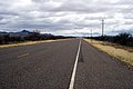
South of Van Horn
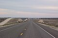
West of Del Rio


San Antonio to Houston[]
East of Downtown San Antonio, US 90 multiplexes with I-10. This overlap ends in Seguin, and continues where the two highways continually cross each other en route to Houston. US 90 once again duplexes with I-10 east of Columbus briefly separating near Brookshire and continue overlapping from Katy all the way to Houston. At I-610 east of Houston, US 90 becomes independently known as the Crosby Freeway.
The Crosby Freeway from east of Beltway 8 to east of Runneburg Road in Crosby, was constructed in the early 1990s and opened to traffic in 1992. After several delays, construction work on the inner section of the freeway began in 2006 and was opened to traffic in January 2011.[1] The western terminus of the Crosby Freeway connects to the I-610 and I-10 interchange via two freeway ramps:
- a ramp from westbound Crosby Freeway, joining an exit ramp from westbound I-10 to enter southbound I-610
- a newly constructed two-lane exit ramp from eastbound I-10 connecting to eastbound Crosby Freeway.
The previous interchange was a four-level stack interchange though the new interchange is not a full five-level stack.
Because of funding constraints, two sections of the freeway inside Beltway 8 were not built to full freeway standards: a half-mile section over Greens Bayou and an approximately mile-long section east of Normandy Street. As of December 2012, only the feeder roads have been constructed, with space reserved in the median for future freeway mainlanes. Unlike most new freeway extensions in the Houston area built in recent decades, the Crosby Freeway is not tolled. Also unlike most of Houston's existing freeways and tollways, the Crosby Freeway does not have continuous feeder roads.
The Crosby Freeway has four to six mainlanes for its entire length.
Houston to Louisiana[]
The US 90 (Beaumont Highway when inside of Beltway 8 or Crosby Freeway when outside of Beltway 8) heads northeast leaving Houston and ends its freeway status in Crosby. US 90 then continues traveling east through Beaumont and is locally known as College Street, passes by Baptist Hospital Beaumont and meets I-10 at a T-interchange. It then passes through Orange and has a business route (Business US 90-Y). It then crosses the Sabine River into Louisiana towards Lake Charles. With the exception of an 11-mile-long (18 km) section with only two (briefly three) lanes between Liberty and Devers, US 90 has at least four lanes between Crosby and the Louisiana state line.
Major intersections[]
| County | Location | mi | km | Destinations | Notes | |||
|---|---|---|---|---|---|---|---|---|
| Culberson | Van Horn | Access to Culberson Hospital; BL-10 is former US 80 | ||||||
| I-10 exit 140A | ||||||||
| | ||||||||
| Lobo | ||||||||
| Jeff Davis | | |||||||
| | ||||||||
| Presidio | Marfa | |||||||
| west end of US 67 overlap | ||||||||
| Brewster | | |||||||
| Alpine | west end of SH 118 overlap | |||||||
| east end of SH 118 overlap | ||||||||
| Altuda | east end of US 67 overlap | |||||||
| Marathon | west end of US 385 overlap | |||||||
| | east end of US 385 overlap | |||||||
| Pecos |
No major junctions | |||||||
| Terrell | Sanderson | |||||||
| Dryden | ||||||||
| | ||||||||
| Val Verde | | |||||||
| | ||||||||
| | over Pecos River | |||||||
| | ||||||||
| Comstock | ||||||||
| | ||||||||
| | ||||||||
| | ||||||||
| Del Rio | ||||||||
| west end of US 277 / US 377 overlap | ||||||||
| east end of US 377 overlap | ||||||||
| east end of US 277 overlap | ||||||||
| interchange | ||||||||
| Kinney | | |||||||
| | ||||||||
| Brackettville | ||||||||
| | ||||||||
| Uvalde | | |||||||
| | over Nueces River | |||||||
| | ||||||||
| Uvalde | ||||||||
| west end of FM 1435 overlap | ||||||||
| east end of FM 1435 overlap | ||||||||
| west end of FM 1023 overlap | ||||||||
| east end of FM 1023 overlap | ||||||||
| | ||||||||
| Knippa | west end of FM 1049 overlap | |||||||
| east end of FM 1049 overlap | ||||||||
| | ||||||||
| Sabinal | ||||||||
| Medina | D'Hanis | |||||||
| Hondo | ||||||||
| west end of FM 462 overlap | ||||||||
| east end of FM 462 overlap; access to Medina Community Hospital | ||||||||
| | interchange | |||||||
| Castroville | ||||||||
| west end of FM 471 overlap | ||||||||
| east end of FM 471 overlap | ||||||||
| Bexar | | interchange | ||||||
| | Montgomery Road | interchange | ||||||
| San Antonio | interchange; west end of freeway | |||||||
| Hunt Lane / Ray Ellison Drive | no direct eastbound exit | |||||||
| I-410 exit 6 | ||||||||
| Old Highway 90 | no direct westbound exit | |||||||
| Callaghan Road | ||||||||
| Acme Road | no direct eastbound exit (signed at Callaghan Road) | |||||||
| westbound exit and eastbound entrance | ||||||||
| 36th Street – Port San Antonio | ||||||||
| General McMullen Drive | ||||||||
| Cupples Road | no direct eastbound exit (signed at General McMullen Drive) | |||||||
| westbound exit and eastbound entrance | ||||||||
| Zarzamora Street | eastbound exit only | |||||||
| eastbound exit and westbound entrance | ||||||||
| west end of I-10 / US 87 overlap; signed as exit 572 | ||||||||
| see I-10 | ||||||||
| Guadalupe | Seguin | east end of I-10 overlap; eastbound exit and westbound entrance; US 90 east follows exit 603 | ||||||
| | ||||||||
| Seguin | ||||||||
| I-10 exit 612 | ||||||||
| SH 130 exit 496 | ||||||||
| Kingsbury | ||||||||
| Caldwell | Luling | west end of US 183 overlap | ||||||
| east end of US 183 overlap | ||||||||
| Gonzales | Harwood | |||||||
| | ||||||||
| Waelder | ||||||||
| | I-10 exit 653 | |||||||
| Fayette | Flatonia | |||||||
| west end of SH 95 overlap | ||||||||
| east end of SH 95 overlap | ||||||||
| | ||||||||
| Engle | ||||||||
| Schulenburg | ||||||||
| | ||||||||
| | I-10 exit 677 | |||||||
| | ||||||||
| Colorado | Weimar | west end of FM 155 overlap | ||||||
| east end of FM 155 overlap | ||||||||
| | I-10 exit 689 | |||||||
| Glidden | ||||||||
| | interchange | |||||||
| Columbus | ||||||||
| over Colorado River | ||||||||
| | west end of I-10 overlap; US 90 west follows exit 698 | |||||||
| see I-10 | ||||||||
| Austin | Sealy | east end of I-10 overlap; US 90 east follows exit 718 | ||||||
| west end of I-10 overlap; westbound exit and eastbound entrance; US 90 west follows exit 721 | ||||||||
| see I-10 | ||||||||
| Waller | | east end of I-10 overlap; US 90 east follows exit 729 | ||||||
| Brookshire | ||||||||
| west end of FM 359 overlap | ||||||||
| east end of FM 359 overlap | ||||||||
| | ||||||||
| Fort Bend | Katy | |||||||
| Harris | west end of I-10 overlap; US 90 west follows exit 741 | |||||||
| see I-10 | ||||||||
| Harris | Houston | east end of I-10 overlap; eastbound exit and westbound entrance; US 90 east follows exit 775B | ||||||
| I-10 exit 775A; I-610 exit 26A; no access from I-610 south to US 90 east | ||||||||
| Mercury Drive | ||||||||
| west end of FM 526 overlap | ||||||||
| east end of FM 526 overlap | ||||||||
| | Access to Sam Houston Tollway via frontage road | |||||||
| | Miller Road No. 3 | |||||||
| | Miller Road No. 2 | |||||||
| Sheldon | Sheldon Road | |||||||
| Frontage Road | Eastbound exit and westbound entrance | |||||||
| Barrett–Crosby line | County Road | |||||||
| No direct westbound exit (signed at Runneburg Road) | ||||||||
| Krenek Road / Runneburg Road | Interchange; east end of freeway | |||||||
| Liberty | | Future interchange | ||||||
| | ||||||||
| Dayton | west end of SH 146 overlap | |||||||
| Liberty | ||||||||
| East end of SH 146 overlap | ||||||||
| Ames | ||||||||
| | ||||||||
| Raywood | West end of FM 770 overlap | |||||||
| East end of FM 770 overlap | ||||||||
| Devers | ||||||||
| | ||||||||
| Jefferson | Nome | |||||||
| Beaumont | ||||||||
| I-10 exit 851 | ||||||||
| see I-10 | ||||||||
| Orange | Orange | Louisiana state line | ||||||
| 1.000 mi = 1.609 km; 1.000 km = 0.621 mi | ||||||||
See also[]
References[]
- ^ a b Transportation Planning and Programming Division (n.d.). "U.S. Highway No. 90". Highway Designation Files. Texas Department of Transportation. Retrieved February 7, 2011.
External links[]
![]() Media related to U.S. Route 90 in Texas at Wikimedia Commons
Media related to U.S. Route 90 in Texas at Wikimedia Commons
- U.S. Highways in Texas
- U.S. Route 90
- Transportation in Culberson County, Texas
- Transportation in Jeff Davis County, Texas
- Transportation in Presidio County, Texas
- Transportation in Brewster County, Texas
- Transportation in Pecos County, Texas
- Transportation in Terrell County, Texas
- Transportation in Val Verde County, Texas
- Transportation in Kinney County, Texas
- Transportation in Uvalde County, Texas
- Transportation in Medina County, Texas
- Transportation in Bexar County, Texas
- Transportation in San Antonio
- Transportation in Guadalupe County, Texas
- Transportation in Caldwell County, Texas
- Transportation in Gonzales County, Texas
- Transportation in Fayette County, Texas
- Transportation in Colorado County, Texas
- Transportation in Austin County, Texas
- Transportation in Waller County, Texas
- Transportation in Fort Bend County, Texas
- Transportation in Harris County, Texas
- Roads in Houston
- Transportation in Liberty County, Texas
- Transportation in Jefferson County, Texas
- Transportation in Orange County, Texas