Brackettville, Texas
Brackettville, Texas | |
|---|---|
City | |
 Location of Brackettville, Texas | |
 | |
| Coordinates: 29°18′55″N 100°24′54″W / 29.31528°N 100.41500°WCoordinates: 29°18′55″N 100°24′54″W / 29.31528°N 100.41500°W | |
| Country | United States |
| State | Texas |
| County | Kinney |
| Area | |
| • Total | 3.17 sq mi (8.21 km2) |
| • Land | 3.17 sq mi (8.21 km2) |
| • Water | 0.00 sq mi (0.00 km2) |
| Elevation | 1,106 ft (337 m) |
| Population (2010) | |
| • Total | 1,688 |
| • Estimate (2019)[4] | 1,686 |
| • Density | 532.03/sq mi (205.42/km2) |
| Time zone | UTC-6 (Central (CST)) |
| • Summer (DST) | UTC-5 (CDT) |
| ZIP code | 78832 |
| Area code(s) | 830 |
| FIPS code | 48-09868[3] |
| GNIS feature ID | 1352804[2] |
| Website | www |

Brackettville is a city in Kinney County, Texas, United States. The population was 1,688 at the 2010 census,[5] down from 1,876 at the 2000 census. It is the county seat of Kinney County.[6]
History[]
Founded in 1852 as "Las Moras" (the name of a nearby spring and the creek it feeds), the town initially was a supply stop on the old San Antonio-El Paso road and a supply depot for the U.S. Army's Fort Clark (the fort was established the same year). Later the town was named "Brackett" after Oscar B. Brackett, the owner of the first dry goods store in the area. In 1873, when a post office was awarded, "ville" was appended to the name to differentiate it from another town.
The town grew quickly through the 19th century with the expansion of the garrison at Fort Clark for the Indian Wars. The town's fortunes were tied to the fort. For many years, it was the base of the famous Buffalo Soldiers, made up of African Americans. Demographically, Brackettville had a larger proportion of Black Seminoles (people of mixed African American and Seminole ancestry, who originated in Florida) than the rest of West Texas, as they had been recruited by the US to act as scouts for the Buffalo Soldiers and settled with their families in the town. During the slavery years, they had been living in a settlement in northern Mexico to escape US conditions. Their language developed in Florida, Afro-Seminole Creole, is still spoken by some in Brackettville.
After the Buffalo Soldiers moved out of Fort Clark with the waning of the Indian Wars, it was used as a cavalry post. The Seminole Negro Indian Scouts were finally disbanded as a unit in 1914. Virtually every cavalry unit in the U.S. Army was stationed at or trained at Fort Clark at one time or another.
In 1943 during World War II, the U.S. Army activated the Second Cavalry Division, which was to be the Army's last horse-mounted unit. By 1944, even the Second had been mechanized. Fort Clark, so long a center of mounted cavalry, was targeted for closure. Before its closure, the fort was used as a German prisoner-of-war camp.
Because of the families of soldiers at the fort and African-American veterans and descendants who had settled here, during the war, the US government funded construction of a high school for black students, which opened in April 1944, so the children of veterans could be educated. The state of Texas was still racially segregated; it had essentially disenfranchised blacks since the early 20th century by its voter registration and electoral requirements, and the white legislature consistently underfunded black education and services. Officially classified as a four-year high school, it is believed to have been the only one of its kind between San Antonio and El Paso at that time.
After the fort officially closed in 1946, it had a variety of uses. In 1971 it was converted and adapted as a resort/retirement center. The historic district of the fort is listed on the National Register of Historic Places. The resort is not the economic engine the fort once was, and Brackettville has shrunk from its peak population during the war years.
Cultural matters[]
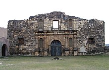
North of town is a tourist attraction called Alamo Village, built in the 1950s as the set of John Wayne's movie The Alamo. Scenes from the 1969 comedy Viva Max! were also shot here. As of July 2009, Alamo Village has been closed to the public. It is available for film production and special events such as weddings and receptions.[7]
In 1958 and 1959, the syndicated western television series Mackenzie's Raiders, starring Richard Carlson as Colonel Ranald Mackenzie, with Morris Ankrum, Louis Jean Heydt, and Jack Ging, was set at the former Fort Clark near Brackettville though it was filmed at the former Fort Apache at the former Corriganville Movie Ranch near Simi Valley, California. The series is based on exploits of the United States Cavalry as it protected the Rio Grande border in the period after the American Civil War.[8]
The miniseries James A. Michener's Texas (1994) was filmed in and around Brackettville.[9] Other films shot in Brackettville include the John Wayne film The Alamo (1960), Two Rode Together (1961), Bandolero! (1968), Barbarosa (1982), Lonesome Dove (1989), and Bad Girls (1994).[10]
Geography[]
Brackettville is located near the center of Kinney County at 29°18′55″N 100°24′54″W / 29.31528°N 100.41500°W (29.315349, -100.415120).[11] It is bordered to the south by Fort Clark Springs, an unincorporated community on the site of the former Fort Clark. U.S. Route 90 runs along the southern edge of Brackettville, leading east 39 miles (63 km) to Uvalde and west 30 miles (48 km) to Del Rio. Texas State Highway 131 runs south from Brackettville 45 miles (72 km) to Eagle Pass.
The closest airport with commercial airline service is Del Rio International Airport, on the west side of Del Rio, 32 miles (51 km) from Brackettville.
According to the United States Census Bureau, Brackettville has a total area of 3.2 square miles (8.2 km2), of which 2.8 square miles (7.3 km2) are land and 0.3 square miles (0.9 km2), or 10.97%, are water.[5]
Demographics[]
| Historical population | |||
|---|---|---|---|
| Census | Pop. | %± | |
| 1880 | 1,126 | — | |
| 1890 | 1,649 | 46.4% | |
| 1930 | 1,822 | — | |
| 1940 | 2,653 | 45.6% | |
| 1950 | 1,858 | −30.0% | |
| 1960 | 1,662 | −10.5% | |
| 1970 | 1,539 | −7.4% | |
| 1980 | 1,676 | 8.9% | |
| 1990 | 1,740 | 3.8% | |
| 2000 | 1,876 | 7.8% | |
| 2010 | 1,688 | −10.0% | |
| 2019 (est.) | 1,686 | [4] | −0.1% |
| U.S. Decennial Census[12] | |||
As of the census[3] of 2000, there were 1,876 people, 618 households, and 438 families residing in the city. The population density was 591.8 people per square mile (228.5/km2). There were 766 housing units at an average density of 241.6 per square mile (93.3/km2). The racial makeup of the city was 64.77% White, 2.67% African American, 0.59% Native American, 0.05% Asian, 28.09% from other races, and 3.84% from two or more races. Hispanic or Latino of any race were 74.36% of the population. According to Ethnologue, there are 200 Afro-Seminole Creole speakers in Brackettville, which makes the town the only one in the country where this creole is still spoken.
There were 618 households, out of which 38.5% had children under the age of 18 living with them, 56.0% were married couples living together, 10.2% had a female householder with no husband present, and 29.1% were non-families. 27.3% of all households were made up of individuals, and 15.9% had someone living alone who was 65 years of age or older. The average household size was 3.00 and the average family size was 3.72.
In the city, the population was spread out, with 33.5% under the age of 18, 7.4% from 18 to 24, 24.6% from 25 to 44, 19.2% from 45 to 64, and 15.4% who were 65 years of age or older. The median age was 33 years. For every 100 females, there were 98.5 males. For every 100 females age 18 and over, there were 96.4 males.
The median income for a household in the city was $19,410, and the median income for a family was $24,063. Males had a median income of $21,806 versus $14,773 for females. The per capita income for the city was $9,332. About 31.2% of families and 33.4% of the population were below the poverty line, including 37.3% of those under age 18 and 30.2% of those age 65 or over.
Education[]
Brackettville is served by the Brackett Independent School District.
Climate[]
The climate in this area is characterized by hot, humid summers and generally mild to cool winters. According to the Köppen Climate Classification system, Brackettville has a humid subtropical climate, abbreviated "Cfa" on climate maps.[13]
References[]
- ^ "2019 U.S. Gazetteer Files". United States Census Bureau. Retrieved August 7, 2020.
- ^ Jump up to: a b U.S. Geological Survey Geographic Names Information System: Brackettville, Texas
- ^ Jump up to: a b "U.S. Census website". United States Census Bureau. Retrieved 2008-01-31.
- ^ Jump up to: a b "Population and Housing Unit Estimates". United States Census Bureau. May 24, 2020. Retrieved May 27, 2020.
- ^ Jump up to: a b "Geographic Identifiers: 2010 Census Summary File 1 (G001), Brackettville city, Texas". American FactFinder. U.S. Census Bureau. Archived from the original on February 13, 2020. Retrieved May 9, 2019.
- ^ "Find a County". National Association of Counties. Archived from the original on 2011-05-31. Retrieved 2011-06-07.
- ^ "The Alamo movie set closes as owners figure out what's next" Archived July 8, 2009, at the Wayback Machine, My San Antonio website
- ^ Billy Hathorn, "Roy Bean, Temple Houston, Bill Longley, Ranald Mackenzie, Buffalo Bill, Jr., and the Texas Rangers: Depictions of West Texans in Series Television, 1955 to 1967", West Texas Historical Review, Vol. 89 (2013), pp. 112-113
- ^ Rowan, Terry (2013). The American Western A Complete Film Guide. Lulu Press, Inc. Page 394. ISBN 9781300418580.
- ^ Maddrey, Joseph (2016). The Quick, the Dead and the Revived: The Many Lives of the Western Film. McFarland. Page 183. ISBN 9781476625492.
- ^ "US Gazetteer files: 2010, 2000, and 1990". United States Census Bureau. 2011-02-12. Retrieved 2011-04-23.
- ^ "Census of Population and Housing". Census.gov. Retrieved June 4, 2015.
- ^ Climate Summary for Brackettville, Texas
External links[]
| show Municipalities and communities of Kinney County, Texas, United States |
|---|


| show Authority control |
|---|
- Cities in Texas
- Cities in Kinney County, Texas
- County seats in Texas
- San Antonio–El Paso Road