Jayton, Texas
Jayton, Texas | |
|---|---|
City | |
| Jayton, Texas | |
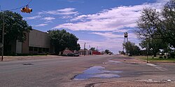 Jayton's water tower and the Kent County Court in 2012 | |
| Motto(s): "Where pride makes the difference!” | |
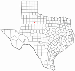 Location of Jayton, Texas | |
 | |
| Coordinates: 33°15′N 100°34′W / 33.250°N 100.567°WCoordinates: 33°15′N 100°34′W / 33.250°N 100.567°W | |
| Country | United States |
| State | Texas |
| County | Kent |
| Area | |
| • Total | 1.70 sq mi (4.39 km2) |
| • Land | 1.70 sq mi (4.39 km2) |
| • Water | 0.00 sq mi (0.00 km2) |
| Elevation | 2,005 ft (611 m) |
| Population (2010) | |
| • Total | 534 |
| • Estimate (2019)[4] | 502 |
| • Density | 295.82/sq mi (114.23/km2) |
| Time zone | UTC-6 (Central (CST)) |
| • Summer (DST) | UTC-5 (CDT) |
| ZIP code | 79528 |
| Area code(s) | 806 |
| FIPS code | 48-37468[2] |
| GNIS feature ID | 1360187[3] |

Jayton is a city in and the county seat of Kent County, Texas, United States.[5] It is located in the northeastern portion of the county, and the population was 534 as of the 2010 census.[6]
History[]
Jayton's history begins in the 1880s. Originally known as "Jay Flat", it was established 2 miles (3 km) northeast of its present location and named after a local ranching family. A post office was granted in 1886, and Daniel Jay served as the community's first postmaster. In 1907, the townsite was moved to its present location for improved proximity to rail service, and it was officially renamed "Jayton" later that same year. The community's first newspaper, the Jayton Herald, was established the following year, and the city incorporated in February 1910. By 1925, Jayton was home to 750 residents.
From the community's inception, the local economy had originally been supported mainly by the cotton industry, but the Dust Bowl of the 1930s had a dire effect on production. The community's economy was stabilized by the discovery of oil later that same decade, and while its population never exceeded 750, Jayton remained stable throughout the Great Depression. In 1954, following a lengthy and heated court battle, the city wrested the title of county seat from the declining nearby community of Clairemont, and in 1957, a courthouse was constructed. Jayton's population remained around 600 from the 1950s through the 1980 census before declining to 513 in 1990 and 441 in 2000, but a resurgence in the local oil industry led to a rebound, and the 2010 census counted 534 residents.
Geography[]
Jayton is located in eastern Kent County at 33°15′N 100°34′W / 33.250°N 100.567°W (33.2493, -100.5748).[7] U.S. Route 380 touches the southern border of the city; the highway leads southeast 24 miles (39 km) to Aspermont and southwest 13 miles (21 km) to Clairemont. Texas State Highway 70 is Jayton's Main Street and leads northwest 24 miles (39 km) to Spur. The closest large cities are Lubbock, 93 miles (150 km) to the northwest, and Abilene, 84 miles (135 km) to the southeast.
According to the United States Census Bureau, Jayton has a total area of 1.7 square miles (4.4 km2), all of it land.[6]
Kent County Airport is south of the city. The airport has one asphalt runway 3,300 feet (1,000 m) in length. The nearest airport with commercial service is roughly 100 miles away in Lubbock.
Demographics[]
| Historical population | |||
|---|---|---|---|
| Census | Pop. | %± | |
| 1910 | 314 | — | |
| 1930 | 623 | — | |
| 1940 | 770 | 23.6% | |
| 1950 | 635 | −17.5% | |
| 1960 | 649 | 2.2% | |
| 1970 | 703 | 8.3% | |
| 1980 | 638 | −9.2% | |
| 1990 | 608 | −4.7% | |
| 2000 | 513 | −15.6% | |
| 2010 | 534 | 4.1% | |
| 2019 (est.) | 502 | [4] | −6.0% |
| U.S. Decennial Census[8] | |||
As of the census[2] of 2000, 513 people, 209 households, and 144 families resided in the city. The population density was 301.6 people per square mile (116.5/km2). The 277 housing units averaged 162.9/sq mi (62.9/km2). The racial makeup of the city was 96.69% White, 0.19% African American, 0.39% Native American, 2.53% from other races, and 0.19% from two or more races. Hispanics or Latinos of any race were 10.92% of the population.
Of the 209 households, 25.8% had children under the age of 18 living with them, 59.3% were married couples living together, 6.2% had a female householder with no husband present, and 31.1% were not families. About 29.2% of all households were made up of individuals, and 15.8% had someone living alone who was 65 years of age or older. The average household size was 2.27 and the average family size was 2.81.
In the city, the population was distributed as 19.7% under the age of 18, 4.9% from 18 to 24, 20.7% from 25 to 44, 27.9% from 45 to 64, and 26.9% who were 65 years of age or older. The median age was 50 years. For every 100 females, there were 84.5 males. For every 100 females age 18 and over, there were 83.1 males.
The median income for a household in the city was $32,396, and for a family was $39,375. Males had a median income of $25,000 versus $21,875 for females. The per capita income for the city was $17,314. About 9.6% of families and 8.8% of the population were below the poverty line, including 5.5% of those under age 18 and 1.0% of those age 65 or over.
Education[]
The city is served by the Jayton-Girard Independent School District, and the local high school is Jayton High School.
Climate[]
According to the Köppen climate classification system, Jayton has a semiarid climate, BSk on climate maps.[9]
In popular culture[]
- Jayton is briefly mentioned in the 2016 film Hell or High Water.
References[]
- ^ "2019 U.S. Gazetteer Files". United States Census Bureau. Retrieved August 7, 2020.
- ^ Jump up to: a b "U.S. Census website". United States Census Bureau. Retrieved 2008-01-31.
- ^ "US Board on Geographic Names". United States Geological Survey. 2007-10-25. Retrieved 2008-01-31.
- ^ Jump up to: a b "Population and Housing Unit Estimates". United States Census Bureau. May 24, 2020. Retrieved May 27, 2020.
- ^ "Find a County". National Association of Counties. Archived from the original on 2011-05-31. Retrieved 2011-06-07.
- ^ Jump up to: a b "Geographic Identifiers: 2010 Census Summary File 1 (G001), Jayton city, Texas". American FactFinder. U.S. Census Bureau. Archived from the original on February 13, 2020. Retrieved May 8, 2019.
- ^ "US Gazetteer files: 2010, 2000, and 1990". United States Census Bureau. 2011-02-12. Retrieved 2011-04-23.
- ^ "Census of Population and Housing". Census.gov. Retrieved June 4, 2015.
- ^ Climate Summary for Jayton, Texas
| show Municipalities and communities of Kent County, Texas, United States |
|---|

| show Authority control |
|---|
- Cities in Texas
- Cities in Kent County, Texas
- County seats in Texas
- 1880s establishments in Texas