Eastland, Texas
Eastland, Texas | |
|---|---|
City | |
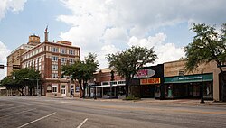 Downtown Eastland, Texas | |
 Location of Eastland, Texas | |
 | |
| Coordinates: 32°23′55″N 98°49′16″W / 32.39861°N 98.82111°WCoordinates: 32°23′55″N 98°49′16″W / 32.39861°N 98.82111°W | |
| Country | United States |
| State | Texas |
| County | Eastland |
| Area | |
| • Total | 4.39 sq mi (11.38 km2) |
| • Land | 4.36 sq mi (11.30 km2) |
| • Water | 0.03 sq mi (0.07 km2) |
| Elevation | 1,440 ft (439 m) |
| Population (2010) | |
| • Total | 3,960 |
| • Estimate (2019)[4] | 3,850 |
| • Density | 882.22/sq mi (340.59/km2) |
| Time zone | UTC-6 (Central (CST)) |
| • Summer (DST) | UTC-5 (CDT) |
| ZIP code | 76448 |
| Area code(s) | 254 |
| FIPS code | 48-22132[2] |
| GNIS feature ID | 1335045[3] |
| Website | www |

Eastland is a city in Eastland County, Texas, United States. Its population was 3,960 at the 2010 census.[5] It is the county seat of Eastland County.[6]
History[]
During the 1920s, Eastland, like nearby Cisco, Ranger, and , was a petroleum boomtown.
Eastland is known for the legend of "Old Rip", a horned toad that allegedly lived many years sealed in the cornerstone of the previous Eastland courthouse built in 1897.
The recession of 1921 exacerbated racial tensions between Anglos and Mexicans. Naturally, unemployment increased in town and Whites attempted to oust Mexicans who were hired during the WWI boom. Masked men ravaged shacks used by Mexicans as living quarters. Whites threatened Mexicans' lives, and fearful, they fled to nearby Fort Worth to seek help from the Mexican Consulate, since local authorities took the side of the Anglo locals.[7]
In 1928, the current courthouse was erected, the prior cornerstone was opened, and "Old Rip" was allegedly found alive. The animal, a kind of lizard, received national publicity. It died in 1929 of pneumonia, and was placed in a glass-front casket on view in the present courthouse.[8]
Geography[]
Eastland is located north of the center of Eastland County at 32°23′55″N 98°49′16″W / 32.39861°N 98.82111°W (32.398715, −98.821144).[9] It is 96 miles (154 km) west-southwest of Fort Worth and 55 miles (89 km) east of Abilene. The city is accessed by Interstate 20 between exits 340 to the south and 343 to the east.
According to the United States Census Bureau, the city has a total area of 3.6 sq mi (9.2 km2), all of it land.[5]
Demographics[]
| Historical population | |||
|---|---|---|---|
| Census | Pop. | %± | |
| 1870 | 88 | — | |
| 1880 | 539 | 512.5% | |
| 1900 | 596 | — | |
| 1910 | 855 | 43.5% | |
| 1920 | 9,368 | 995.7% | |
| 1930 | 4,648 | −50.4% | |
| 1940 | 3,849 | −17.2% | |
| 1950 | 3,626 | −5.8% | |
| 1960 | 3,292 | −9.2% | |
| 1970 | 3,178 | −3.5% | |
| 1980 | 3,747 | 17.9% | |
| 1990 | 3,690 | −1.5% | |
| 2000 | 3,769 | 2.1% | |
| 2010 | 3,960 | 5.1% | |
| 2019 (est.) | 3,850 | [4] | −2.8% |
| U.S. Decennial Census[10] | |||
As of the census[2] of 2000, 3,769 people, 1,475 households, and 998 families were living in the city. The population density was 1,333.1 people/ sq mi (514.2/km2). The 1,737 housing units averaged 614.4/sq mi (237.0/km2). The racial makeup of the city was 91.64% White, 1.80% African American, 0.53% Native American, 0.13% Asian, 4.72% from other races, and 1.17% from two or more races. Hispanics or Latinos of any race were 12.89% of the population.
Of the 1,475 households, 33.8% had children under 18 living with them, 53.2% were married couples living together, 10.8% had a female householder with no husband present, and 32.3% were not families. About 29.4% of all households were made up of individuals, and 15.5% had someone living alone who was 65 or older. The average household size was 2.45, and the average family size was 3.04.
In the city, theage distribution was 25.7% under 18, 9.1% from 18 to 24, 25.2% from 25 to 44, 20.2% from 45 to 64, and 19.8% who were 65 or older. The median age was 38 years. For every 100 females, there were 89.6 males. For every 100 females age 18 and over, there were 85.2 males.
The median income for a household in the city was $28,277, and for a family was $34,333. Males had a median income of $27,072 versus $16,574 for females. The per capita income for the city was $17,339. About 14.2% of families and 17.0% of the population were below the poverty line, including 25.0% of those under age 18 and 12.7% of those age 65 or over.
Government[]
The Texas Eleventh Court of Appeals is located in the Eastland County Courthouse in Eastland.[11]
Education[]
The city is served by the Eastland Independent School District and is home of the Eastland Mavericks.
Notable people[]
- Emma Carter Browning (1910–2010), aviation executive and pilot
- Hayden Fry (1929–2019), college football coach
- Ira L. Hanna (1908–1978), 36th mayor of Cheyenne, Wyoming
- Richard D. Lawrence, United States Army lieutenant general
- Don Pierson (1925–1996), former mayor of Eastland, business innovator, communications pioneer (Radio England), and civic leader
- Doc Scurlock (1849–1929), Old West figure and founding member of the Regulators, who rode with such men as Billy the Kid
- Barney Smith
- (1895–1983), an engineer with the Oil Belt Power Company, lived in Eastland during the early 1920s.
Climate[]
The climate in this area is characterized by hot, humid summers and generally mild to cool winters. According to the Köppen climate classification, Eastland has a humid subtropical climate, Cfa on climate maps.[12]
Gallery[]

Centennial Memorial Library in Eastland
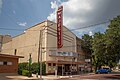
The Majestic Theatre in Eastland

Facade of historic First United Methodist Church of Eastland

The Eastland Historic Hotel

First Christian Church in downtown Eastland

First Baptist Church in Eastland

Downtown Eastland
Eastland Town Square


References[]
- ^ "2019 U.S. Gazetteer Files". United States Census Bureau. Retrieved August 7, 2020.
- ^ Jump up to: a b "U.S. Census website". United States Census Bureau. Retrieved 2008-01-31.
- ^ "US Board on Geographic Names". United States Geological Survey. 2007-10-25. Retrieved 2008-01-31.
- ^ Jump up to: a b "Population and Housing Unit Estimates". United States Census Bureau. May 24, 2020. Retrieved May 27, 2020.
- ^ Jump up to: a b "Geographic Identifiers: 2010 Census Summary File 1 (G001): Eastland city, Texas". American Factfinder. U.S. Census Bureau. Archived from the original on February 13, 2020. Retrieved March 22, 2016.
- ^ "Find a County". National Association of Counties. Archived from the original on 2012-07-12. Retrieved 2011-06-07.
- ^ Chicano! The History of the Mexican American Civil Rights Movement, p. 113
- ^ "Eastland, Texas", 2009 Texas State Travel Guide, p. 121
- ^ "US Gazetteer files: 2010, 2000, and 1990". United States Census Bureau. 2011-02-12. Retrieved 2011-04-23.
- ^ "Census of Population and Housing". Census.gov. Retrieved June 4, 2015.
- ^ "Contact Information Archived 2010-01-25 at the Wayback Machine." Texas Eleventh Court of Appeals. Retrieved on March 10, 2010.
- ^ Climate Summary for Eastland, Texas
External links[]
- City of Eastland official website
- Eastland Chamber of Commerce
- Community site sponsored by the Eastland Economic Development Corporation
- Eastland Independent School District
- KATX radio
- Eastland County Today, local newspapers
- MicroplexNews, local independent news outlet
| show Municipalities and communities of Eastland County, Texas, United States |
|---|


| show Authority control |
|---|
- Cities in Texas
- Cities in Eastland County, Texas
- County seats in Texas