Sierra Blanca, Texas
Sierra Blanca, Texas | |
|---|---|
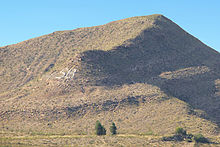
 Sierra Blanca with "SB" on mountain in the background | |
 | |
| Coordinates: 31°10′55″N 105°20′27″W / 31.18194°N 105.34083°WCoordinates: 31°10′55″N 105°20′27″W / 31.18194°N 105.34083°W | |
| Country | United States |
| State | Texas |
| County | Hudspeth |
| Area | |
| • Total | 4.8 sq mi (12.4 km2) |
| • Land | 4.7 sq mi (12.3 km2) |
| • Water | 0.04 sq mi (0.1 km2) |
| Elevation | 4,528 ft (1,380 m) |
| Population (2010) | |
| • Total | 553 |
| • Density | 116/sq mi (44.9/km2) |
| Time zone | UTC-7 (Mountain (MST)) |
| • Summer (DST) | UTC-6 (MDT) |
| ZIP code | 79851 |
| Area code(s) | 915 |
| FIPS code | 48-67772[1] |
| GNIS feature ID | 1368253[2] |

Sierra Blanca is an unincorporated area in Hudspeth County, Texas, United States. It is also the county seat of the county and the namesake of a census-designated place (CDP) in which it is located.[3] The town is part of the Trans-Pecos region of far West Texas, is located northeast of the Mexican border and is within the Mountain Time Zone. As of the 2010 census, its population was 553.[4]
The town was founded in 1881 at the completion point of a long-sought southern transcontinental railway.[5] Sierra Blanca has served as the junction of the Southern Pacific and Missouri Pacific railroads. Hudspeth County was formed in 1917 from El Paso County. Sierra Blanca was named the county seat, and has the only adobe courthouse[6] in Texas.
The town continues to accommodate travelers between Van Horn and El Paso along Interstate 10, which is the main route that connects Texas from west to southeast. The town was named for the nearby Sierra Blanca Mountain, which was in turn named for the white poppies that grew there (sierra blanca is Spanish for "white mountain").[7][8]
The letters "SB" can be seen on a nearby mountain from Interstate 10.
Geography[]
Sierra Blanca is found in Far West Texas, a subdivision of West Texas,[9] and is located at 31°10′55″N 105°20′27″W / 31.18194°N 105.34083°W (31.182009, -105.340843)[10] 4,520 feet (1,380 m) above sea level. The town is part of the Trans-Pecos region within the most mountainous and arid portion of Texas. The town is located in Hudspeth County, which is large and sparsely populated. Sierra Blanca (White Mountain), at an elevation over 7,000 feet (2,100 m) above sea level, towers over the town to the northwest and is the most prominent mountain peak of the surrounding mountainous terrain.
According to the United States Census Bureau, the CDP has a total area of 4.8 square miles (12.4 km2), of which 4.7 square miles (12.3 km2) are land and 0.04 square miles (0.1 km2), or 0.52%, is covered by water.[4] Soil in the surrounding area is mostly nonarable due to lack of water, so cannot sustain large-scale farming. Due to the high altitude of the town, it has a cooler climate than other areas of the Chihuahuan Desert.
Climate[]
Summers are hot with mild nights. The town occasionally experiences high winds and dust storms. July is normally the warmest month, with the highest recorded temperature in town being 109 °F (43 °C) in 1994. During the winter, the jet stream periodically dips far south and brings extremely low temperatures. December is usually the coolest month and the lowest temperature recorded was −10 °F (−23 °C) in 1985.
Normally, the town receives less than 1 inch (25 mm) of snow annually. During the hurricane season, tropical storms can sometimes bring large amounts of precipitation to the arid mountainous region and can cause flash flooding. Precipitation is low; the town and vicinity receive an average of 11.24 inches (285 mm) of precipitation annually, with 45 days having rain.
| hideClimate data for Sierra Blanca 2 E, Texas, 1981-2010 normals, extremes 1893-2002 | |||||||||||||
|---|---|---|---|---|---|---|---|---|---|---|---|---|---|
| Month | Jan | Feb | Mar | Apr | May | Jun | Jul | Aug | Sep | Oct | Nov | Dec | Year |
| Record high °F (°C) | 77 (25) |
89 (32) |
89 (32) |
96 (36) |
103 (39) |
109 (43) |
108 (42) |
102 (39) |
99 (37) |
94 (34) |
89 (32) |
88 (31) |
109 (43) |
| Average high °F (°C) | 57.9 (14.4) |
63.0 (17.2) |
69.4 (20.8) |
77.9 (25.5) |
86.9 (30.5) |
94.1 (34.5) |
92.5 (33.6) |
90.1 (32.3) |
86.5 (30.3) |
78.3 (25.7) |
66.9 (19.4) |
57.8 (14.3) |
76.8 (24.9) |
| Average low °F (°C) | 25.7 (−3.5) |
28.8 (−1.8) |
35.2 (1.8) |
42.6 (5.9) |
52.3 (11.3) |
60.6 (15.9) |
63.5 (17.5) |
62.0 (16.7) |
55.9 (13.3) |
44.1 (6.7) |
33.2 (0.7) |
25.6 (−3.6) |
44.1 (6.7) |
| Record low °F (°C) | 4 (−16) |
−10 (−23) |
6 (−14) |
19 (−7) |
26 (−3) |
40 (4) |
50 (10) |
49 (9) |
36 (2) |
19 (−7) |
7 (−14) |
1 (−17) |
−10 (−23) |
| Average precipitation inches (mm) | 0.40 (10) |
0.65 (17) |
0.30 (7.6) |
0.33 (8.4) |
0.52 (13) |
1.13 (29) |
2.13 (54) |
2.15 (55) |
1.45 (37) |
1.15 (29) |
0.41 (10) |
0.62 (16) |
11.24 (286) |
| Average precipitation days (≥ 0.01 in) | 3.2 | 2.6 | 2.0 | 1.6 | 2.5 | 4.5 | 6.4 | 7.3 | 5.1 | 3.9 | 2.7 | 3.3 | 45.1 |
| Source 1: NOAA (normals)[11] | |||||||||||||
| Source 2: Western Regional Climate Center (extremes)[12] | |||||||||||||
Demographics[]

As of the 2010 census, 553 people, 172 households, and 126 families were residing in the CDP. The population density was 116.0 people/sq mi (50.6/km2). The 227 housing units averaged 55.8/sq mi (21.5/km2). The racial makeup of the CDP was 83.91% White, 3.44% Native American, 3.25% Black, 1.45% Asian, 7.96% from other races, and 3.56% from two or more races. Latinos of any race were 72.61% of the population.
Of the 172 households, 40.2% had children under 18 living with them, 45.72% were married couples living together, 13.0% had a female householder with no husband present, and 31.0% were not families. About 28.3% of all households were made up of individuals, and 11.4% had someone living alone who was 65 or older. The average household size was 2.63, and the average family size was 3.31.
In the CDP, theage distribution was 29.8% under 18, 11.8% from 18 to 24, 30.8% from 25 to 44, 18.4% from 45 to 64, and 9.2% who were 65 or older. The median age was 34.3 years. For every 100 females, there were 96.0 males. For every 100 females age 18 and over, there were 101.1 males. The median income for a household in the CDP was $32,464. The per capita income for the CDP was $14,682. About 19.6% of families and 22.5% of the population were below the poverty line, including 28.3% of those under age 18 and 32.6% of those age 65 or over.
Education[]
Sierra Blanca is served by the Sierra Blanca Independent School District; it spends an annual average of $6,343 per student. On average, the schools have 10.9 students per teacher. For the demographic group older than 25 years, 68.6% have a high school degree, 3.2% have a bachelor's degree, and 2.6% have a graduate degree.
Hudspeth County is in the official service area of El Paso Community College.[13]
Economy[]
The cost of living in Sierra Blanca is about 20% less than the US average. The CDP has a home ownership rate of 49.5%. The median home is valued at $54,600 with a 1.94% annual appreciation.
Starting in 1992, a few miles from Sierra Blanca was the location of a sludge dump that received 250 tons of treated sewage each day by train from New York City. The practice was discontinued in 2001, after local complaints about odor and negative impact on health.[14][15]
In the late 1990s, the Texas Low-Level Radioactive Waste Disposal Authority proposed a nuclear waste site near Sierra Blanca.[16] The waste site was thought to bring an economic boost to the town. This proposal was eventually declined, citing concerns about the site being in the most seismically active region of Texas.[17]
Press reports indicated that in 2013, the town supported three restaurants and a motel. No grocery store is in the community.[18]
Law enforcement[]

In September 2012, singer Fiona Apple was arrested at a checkpoint for possession of small amounts of marijuana and hashish, and spent the night in jail there.[19] A few weeks later, a Nelly tour bus was stopped at the same checkpoint, and 10 lb of marijuana were found on the bus along with heroin and a loaded gun. The singer was not arrested, but a member of his entourage was.[20] Previously, rapper Snoop Dogg, musician Willie Nelson, and actor Armie Hammer had all been arrested separately for drug possession in Sierra Blanca.[19] The United States Border Patrol checkpoint at Sierra Blanca sends the county thousands of drug cases a year and inspects 15,000 to 20,000 vehicles every day.[19] The county is unable to prosecute the vast majority of these cases, as the federal government no longer funds such activities.[18]
Accidents[]
On July 13, 1944, three Army Air Forces crews from Biggs Army Airfield, 86 miles west of Sierra Blanca, took off on a practice mission. They proceeded to drop 10 practice bombs on Sierra Blanca. Five of the bombs disabled the main line shared by the Southern Pacific and Texas & Pacific Railroads. Another dropped on a gas station driveway, but missed the fuel tanks. No injuries or deaths were reported.
References[]
- ^ "U.S. Census website". United States Census Bureau. Retrieved 2008-01-31.
- ^ "US Board on Geographic Names". United States Geological Survey. 2007-10-25. Retrieved 2008-01-31.
- ^ "Find a County". National Association of Counties. Retrieved 2011-06-07.
- ^ Jump up to: a b "Geographic Identifiers: 2010 Census Summary File 1 (G001): Sierra Blanca CDP, Texas". American Factfinder. U.S. Census Bureau. Archived from the original on February 13, 2020. Retrieved March 19, 2018.
- ^ "Sierra Blanca". The Handbook of Texas Online. Texas State Historical Association. Retrieved 2012-09-21.
- ^ "Hudspeth Courthouse". Texas Escapes - Blueprints For Travel, LLC. Retrieved 12 May 2010. Texas Escapes - Blueprints For Travel, LLC.
- ^ "Sierra Blanca, Texas". TexasEscapes.com. Retrieved 2012-09-21.
- ^ "Texas Legacy Project: Conservation Archive and Documentary: Transcript: Bill Addington". TexasLegacy.org. 2001-03-28. Retrieved 2012-09-21.
- ^ Greene, A.C. 1998. Sketches from the five states of Texas. College Station: Texas A&M University Press, 176 pp.
- ^ "US Gazetteer files: 2010, 2000, and 1990". United States Census Bureau. 2011-02-12. Retrieved 2011-04-23.
- ^ "Normals Monthly Station Details". National Oceanic and Atmospheric Administration. Retrieved February 13, 2021.
- ^ "SIERRA BLANCA 2 E, TEXAS (418305)". Western Regional Climate Center. Retrieved February 13, 2021.
- ^ Texas Education Code, Section 130.178, "El Paso County Community College District Service Area".
- ^ Yardley, Jim (2007-07-27). "New York's Sewage Was a Texas Town's Gold". The New York Times. Retrieved 2009-03-18.
- ^ "Sierra Blanca, the Nation's Largest Sewage Dump", Toxic Texas, http://www.txpeer.org/toxictour/merco.html, retrieved August 7, 2017.
- ^ "Texas Low-Level Radioactive Waste Disposal Authority: An Inventory of Low-Level Radioactive Waste Disposal Authority Records at the Texas State Archives, 1917, 1920, 1933-1999, undated, bulk 1995-1998". Texas State Library Archives. Retrieved 25 February 2020.
- ^ "Texas Agency Denies Permit For Waste Site". New York Times. September 2, 1998. Retrieved February 24, 2020.
- ^ Jump up to: a b "Minor drug busts at border checkpoint breaking Texas county's budget", by Andrew Becker and G. W. Shulz, 19 June 2013, Center for Investigative Reporting
- ^ Jump up to: a b c "Fiona Apple reportedly arrested for hash possession". Washington Post. TMZ. 20 September 2012. Retrieved 2019-01-09.
- ^ "Rapper Nelly: Cops Raid Tour Bus, Heroin Seized". TMZ. TMZ. 12 October 2012. Retrieved 2012-10-12.
| show Municipalities and communities of Hudspeth County, Texas, United States |
|---|


| Authority control |
|
|---|
- Census-designated places in Hudspeth County, Texas
- Census-designated places in Texas
- County seats in Texas