Bira (river)
| Bira | |
|---|---|
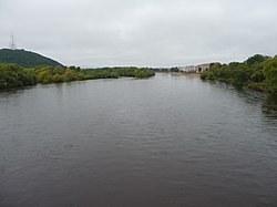 The Bira in Birobidzhan | |
| Location | |
| Country | Russia |
| Physical characteristics | |
| Source | confluence of Sutara and Kuldur |
| • coordinates | 48°58′48″N 131°41′02″E / 48.98000°N 131.68389°E |
| Mouth | Amur |
• coordinates | 48°08′58″N 133°17′33″E / 48.1495°N 133.2925°ECoordinates: 48°08′58″N 133°17′33″E / 48.1495°N 133.2925°E |
| Length | 86 km (53 mi) |
| Basin size | 9,580 km2 (3,700 sq mi) |
| Basin features | |
| Progression | Amur→ Sea of Okhotsk |

The Bira (Russian: Бира) is a river in the Jewish Autonomous Oblast, Russia. The name derives from the Jurchen and Manchu word bira meaning "river". It is 261 kilometres (162 mi) long, and has a drainage basin of 9,580 square kilometres (3,700 sq mi).[1] It is one of the largest, left tributaries of the Amur.
Some of the cities that lie along the river are Birakan, Teploozyorsk, Londoko, Bira, Birobidzhan[2] and Nadezhdinskoye.
See also[]
References[]
- ^ Река БИРА in the State Water Register of Russia (Russian)
- ^ "Birobidzhan | Russia | Britannica".
External links[]
 Media related to Bira River at Wikimedia Commons
This article related to a river in Russia is a stub. You can help Wikipedia by . |
Categories:
- Tributaries of the Amur
- Rivers of Jewish Autonomous Oblast
- Russia river stubs