Blow's Down
| Site of Special Scientific Interest | |
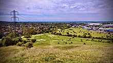 Northwest-facing view from the viewpoint at Blow's Downs SSSI. | |
| Location | Bedfordshire |
|---|---|
| Grid reference | TL033214 |
| Interest | Biological |
| Area | 33.1 hectares |
| Notification | 1989 |
| Location map | Magic Map |

Blow's Down is a 33.1 hectare biological Site of Special Scientific Interest in Dunstable in Bedfordshire. It was notified in 1989 under Section 28 of the Wildlife and Countryside Act 1981, and the local planning authority is Central Bedfordshire Council.[1][2] The site forms around half of the 62.3 hectare Blow's Downs nature reserve, which is managed by the Wildlife Trust for Bedfordshire, Cambridgeshire and Northamptonshire.[3]
The site has varied habitats with a large area of unimproved grassland, a scarce survival of this important habitat. Cattle help to maintain the pasture. Features include a disused quarry and medieval cultivation terraces. It has a rare plant, Bunium bulbocastanum, and beetle odontaeus armiger.[1]
There is access from Jardine Way and Half Moon Lane.[2]

References[]
- ^ a b "Blow's Down citation" (PDF). Sites of Special Scientific Interest. Natural England. Archived from the original (PDF) on 4 March 2016. Retrieved 24 August 2015.
- ^ a b "Map of Blow's Down". Sites of Special Scientific Interest. Natural England. Retrieved 24 August 2015.
- ^ "Blow's Downs". Wildlife Trust for Bedfordshire, Cambridgeshire and Northamptonshire. Retrieved 24 August 2015.
- Sites of Special Scientific Interest in Bedfordshire
- Wildlife Trust for Bedfordshire, Cambridgeshire and Northamptonshire reserves