Bluewell, West Virginia
Bluewell, West Virginia | |
|---|---|
Census-designated place | |
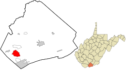 Location in Mercer County and the state of West Virginia. | |
| Coordinates: 37°18′45″N 81°15′35″W / 37.31250°N 81.25972°WCoordinates: 37°18′45″N 81°15′35″W / 37.31250°N 81.25972°W[1] | |
| Country | United States |
| State | West Virginia |
| County | Mercer |
| Area | |
| • Total | 4.522 sq mi (11.711697 km2) |
| • Land | 4.494 sq mi (11.639073 km2) |
| • Water | 0.028 sq mi (0.072624 km2) |
| Elevation | 2,595 ft (791 m) |
| Population | |
| • Total | 2,184 |
| • Density | 480/sq mi (190/km2) |
| Time zone | UTC-5 (Eastern (EST)) |
| • Summer (DST) | UTC-4 (EDT) |
| ZIP code | 24701 |
| Area codes | 304, 681 |
| GNIS feature ID | 54-08764 |

Bluewell, West Virginia is an unincorporated census-designated place on U.S. Route 52 in Mercer County, West Virginia, United States. As of the 2010 census, its population is 2,184. It is the terminus of West Virginia Route 20.
The community has no post office, its residences being a part of Bluefield for postal purposes. Its name is derived from being halfway between Bluefield and Bramwell.
The community is home to several businesses and establishments including Dish Network, Buffalo Trail Cabins and Restaurant and Lasting Impressions Flowers & Custom Gifts]].
The community is adjacent to Pinnacle Rock State Park.
Educational institutions[]
References[]
- ^ a b "US Gazetteer files: 2010, 2000, and 1990". United States Census Bureau. 2011-02-12. Retrieved 2011-04-23.
- ^ "U.S. Census website". United States Census Bureau. Retrieved 2011-05-14.
See also[]
Municipalities and communities of Mercer County, West Virginia, United States | ||
|---|---|---|
| Cities |  | |
| Towns | ||
| CDPs | ||
| Other communities |
| |
| Ghost town | ||
| Footnotes | ‡This populated place also has portions in an adjacent county or counties | |
| ||

This article about a location in Mercer County, West Virginia is a stub. You can help Wikipedia by . |
Categories:
- Census-designated places in Mercer County, West Virginia
- Census-designated places in West Virginia
- Mercer County, West Virginia geography stubs