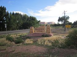
Bluff, Utah
Bluff, Utah | |
|---|---|
Incorporated town and municipality | |
 | |
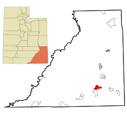 Location in San Juan County and the state of Utah. | |
| Coordinates: 37°17′04″N 109°33′06″W / 37.28444°N 109.55167°WCoordinates: 37°17′04″N 109°33′06″W / 37.28444°N 109.55167°W[2] | |
| Country | United States |
| State | Utah |
| County | San Juan |
| Founded | April 6, 1880 |
| Incorporated | August 31, 2018 |
| Founded by | Silas S. Smith |
| Named for | Bluffs (cliffs) along the San Juan River |
| Government | |
| • Type | Mayor-council government |
| • Mayor | Ann Lepanen |
| Area | |
| • Total | 36.71 sq mi (95.08 km2) |
| • Land | 36.47 sq mi (94.45 km2) |
| • Water | 0.24 sq mi (0.63 km2) |
| Elevation | 4,324 ft (1,317 m) |
| Population (2010) | |
| • Estimate (2019)[4] | 245 |
| • Density | 6.72/sq mi (2.59/km2) |
| Time zone | UTC-7 (Mountain (MST)) |
| • Summer (DST) | UTC-6 (MDT) |
| ZIP code | 84512 |
| Area code(s) | 435 |
| FIPS code | 49-06700[3] |
| GNIS feature ID | 1425842[2] |
| Website | http://townofbluff.org/ footnotes = |

Bluff is a town in San Juan County, Utah, United States. The population was 320 at the 2000 census. Bluff incorporated in 2018.[5]
History[]
Under the direction of John Taylor, Silas S. Smith and Danish settler Jens Nielson led about 230 Mormons on expedition to start a farming community in southeastern Utah. After forging about 200 miles (320 kilometers) of their own trail over difficult terrain, the settlers arrived on the site of Bluff in April 1880.[6] (The trail followed went over and down the "Hole in the Rock", which now opens into one of the tributaries of Lake Powell.) The town was named for the bluffs near the town site.[7] The town's population had declined to seventy by 1930[citation needed] but rebounded during a uranium prospecting boom in the 1950s.[6] With the uranium decline in the 1970s Bluff again declined and now remains a small town with about 200 residents.
Geography[]
Bluff is located in the sparsely populated southeastern Utah canyonlands of the Colorado Plateau. The community is on the north margin of the San Juan River valley at the confluence of Cottonwood Wash with the San Juan. U.S. routes 163 and 191 and State Route 162 pass through the community.[8]
According to the United States Census Bureau, the town has a total area of 22.6 square miles (58.7 km2), of which 22.1 square miles (57.2 km2) is land and 0.6 square mile (1.4 km2) (2.43%) is water.
Climate[]
Bluff has a cold desert climate (Köppen BWk) typical of southern Utah, though it borders on a cold semi-arid climate (BSk). Winters are cool and dry with occasional snow. Despite averaging just over 8” of snow per year, only three seasons have gone without snow (1928-1929, 1963-1964 and 1995-1996). The snowiest season was 1978-1979, with 28.0”. Nights are chilly, falling below freezing on 141 days per year, while only seven days fail to rise above freezing. Bluff is located in hardiness zone 7A, with an average yearly low of 1. Spring comes quickly in February and is the driest time of the year. Temperatures are usually warm, although snow has fallen as late as April (although very rarely). The average last freeze is April 25. Summer is long and hot with occasional thunderstorms. Days reach 90 degrees an average of 86 days per year and attain highs of 100 or greater on 16. Despite the hot days, nights cool to the low 60s. While September is still hot, temperatures cool down rapidly in October and November. Snow has fallen in October, but usually holds off until late November. The first freeze typically comes on October 7.
| hideClimate data for Bluff 1981-2010, extremes 1911-2018 | |||||||||||||
|---|---|---|---|---|---|---|---|---|---|---|---|---|---|
| Month | Jan | Feb | Mar | Apr | May | Jun | Jul | Aug | Sep | Oct | Nov | Dec | Year |
| Record high °F (°C) | 69 (21) |
76 (24) |
86 (30) |
94 (34) |
102 (39) |
106 (41) |
109 (43) |
106 (41) |
100 (38) |
95 (35) |
85 (29) |
69 (21) |
109 (43) |
| Average high °F (°C) | 44.4 (6.9) |
52.3 (11.3) |
62.9 (17.2) |
72.0 (22.2) |
81.8 (27.7) |
92.0 (33.3) |
96.5 (35.8) |
93.4 (34.1) |
84.8 (29.3) |
71.0 (21.7) |
55.8 (13.2) |
44.4 (6.9) |
70.9 (21.6) |
| Average low °F (°C) | 20.2 (−6.6) |
25.5 (−3.6) |
32.4 (0.2) |
39.2 (4.0) |
47.9 (8.8) |
55.0 (12.8) |
63.1 (17.3) |
61.8 (16.6) |
51.6 (10.9) |
38.4 (3.6) |
27.5 (−2.5) |
20.1 (−6.6) |
40.2 (4.6) |
| Record low °F (°C) | −22 (−30) |
−13 (−25) |
4 (−16) |
16 (−9) |
23 (−5) |
33 (1) |
40 (4) |
37 (3) |
23 (−5) |
10 (−12) |
−2 (−19) |
−22 (−30) |
−22 (−30) |
| Average precipitation inches (mm) | 0.74 (19) |
0.66 (17) |
0.56 (14) |
0.50 (13) |
0.49 (12) |
0.19 (4.8) |
0.70 (18) |
0.84 (21) |
0.90 (23) |
0.85 (22) |
0.69 (18) |
0.65 (17) |
7.77 (198.8) |
| Average snowfall inches (cm) | 2.9 (7.4) |
2.1 (5.3) |
0.2 (0.51) |
0.1 (0.25) |
0 (0) |
0 (0) |
0 (0) |
0 (0) |
0 (0) |
— | 0.4 (1.0) |
2.8 (7.1) |
8.5 (22) |
| Average precipitation days (≥ 0.01 in) | 4.3 | 4.3 | 3.4 | 3.3 | 2.9 | 1.5 | 4.2 | 4.9 | 4.1 | 4.1 | 3.1 | 3.6 | 43.7 |
| Average snowy days (≥ 0.1 in) | 1.7 | 1.1 | 0.1 | 0.1 | 0 | 0 | 0 | 0 | 0 | 0.1 | 0.2 | 1.4 | 4.7 |
| Source: NWS Nowdata for Bluff from NWS Salt Lake City. Normals 1981-2010, extremes since 1911. | |||||||||||||
Demographics[]
| Historical population | |||
|---|---|---|---|
| Census | Pop. | %± | |
| 2019 (est.) | 245 | [4] | |
As of the census[3] of 2000, there were 320 people, 135 households, and 75 families residing in the town. The population density was 14.5 people per square mile (5.6/km2). There were 191 housing units at an average density of 8.6/sq mi (3.3/km2). The racial makeup of the town was 62.50% White, 35.00% Native American, 0.94% from other races, and 1.56% from two or more races. Hispanic or Latino of any race were 4.06% of the population.
There were 135 households, out of which 28.9% had children under the age of 18 living with them, 47.4% were married couples living together, 5.9% had a female householder with no husband present, and 44.4% were non-families. 35.6% of all households were made up of individuals, and 5.2% had someone living alone who was 65 years of age or older. The average household size was 2.37 and the average family size was 3.25.
In the town, the population was spread out, with 25.9% under the age of 18, 8.8% from 18 to 24, 29.1% from 25 to 44, 25.6% from 45 to 64, and 10.6% who were 65 years of age or older. The median age was 38 years. For every 100 females, there were 102.5 males. For every 100 females age 18 and over, there were 104.3 males.

The median income for a household in the town was $23,906, and the median income for a family was $30,938. Males had a median income of $31,563 versus $14,792 for females. The per capita income for the CDP was $13,567. About 22.8% of families and 21.9% of the population were below the poverty line, including 27.7% of those under age 18 and 25.0% of those age 65 or over.
Education[]
The San Juan School District operates Bluff Elementary School in Bluff.
Attractions and events[]

- Winter Balloon Festival, January [10]
- Bluff Arts Festival, October and Utah Navajo Fair, September[11]
- Navajo Twin Rocks
- Bluff Fort
- Bears Ears Education Center
Notable people[]
- Charles Lang, Academy Award-winning cinematographer
- Albert R. Lyman, writer
- Jane McKechnie Walton, pioneer
- Ellen Meloy, writer
See also[]
References[]
- ^ "2019 U.S. Gazetteer Files". United States Census Bureau. Retrieved August 7, 2020.
- ^ Jump up to: a b c U.S. Geological Survey Geographic Names Information System: Bluff, Utah
- ^ Jump up to: a b "U.S. Census website". United States Census Bureau. Retrieved 2008-01-31.
- ^ Jump up to: a b "Population and Housing Unit Estimates". United States Census Bureau. May 24, 2020. Retrieved May 27, 2020.
- ^ http://www.sjrnews.com/view/full_story/27594097/article-From-Silver-Dollar-Bar-to-education-center?instance=top_stories
- ^ Jump up to: a b History of Bluff
- ^ Van Atta, Dale (Jan 22, 1977). "You name it - there's a town for it". The Deseret News. p. 15. Retrieved 18 October 2015.
- ^ Bluff, UT, 7.5 Minute Topographic Quadrangle, USGS, 1989
- ^ "Census of Population and Housing". Census.gov. Retrieved June 4, 2016.
- ^ Balloon Festival
- ^ [1] Bluff Calendar]
External links[]
| Wikimedia Commons has media related to Bluff, Utah. |
| show Municipalities and communities of San Juan County, Utah, United States |
|---|

| show Authority control |
|---|
- Census-designated places in San Juan County, Utah
- Census-designated places in Utah
- Populated places established in 1880
- 1880 establishments in Utah Territory