Bořislav
Bořislav | |
|---|---|
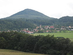 Bořislav with Milešovka hill | |
 Flag  Coat of arms | |
 Bořislav Location in the Czech Republic | |
| Coordinates: 50°34′46″N 13°55′45″E / 50.57944°N 13.92917°ECoordinates: 50°34′46″N 13°55′45″E / 50.57944°N 13.92917°E | |
| Country | |
| Region | Ústí nad Labem |
| District | Teplice |
| First mentioned | 1169 |
| Area | |
| • Total | 7.51 km2 (2.90 sq mi) |
| Elevation | 361 m (1,184 ft) |
| Population (2021-01-01)[1] | |
| • Total | 410 |
| • Density | 55/km2 (140/sq mi) |
| Time zone | UTC+1 (CET) |
| • Summer (DST) | UTC+2 (CEST) |
| Postal code | 415 01 |
| Website | www |

Bořislav Czech pronunciation: [ˈbor̝ɪslaf] (German: Boreslau) is a municipality and village in Teplice District in the Ústí nad Labem Region of the Czech Republic. It has about 400 inhabitants.
Bořislav lies approximately 11 kilometres (7 mi) south-east of Teplice, 12 km (7 mi) south-west of Ústí nad Labem, and 65 km (40 mi) north-west of Prague.
Administrative parts[]
The village of Bílka is an administrative part of Bořislav.
References[]
| Wikimedia Commons has media related to Bořislav. |
| Authority control: National libraries |
|---|
This Ústí nad Labem Region location article is a stub. You can help Wikipedia by . |
Categories:
- Villages in Teplice District
- Ústí nad Labem Region geography stubs