Hrob
Hrob | |
|---|---|
 Mírové Square | |
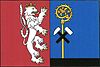 Flag  Coat of arms | |
 Hrob Location in the Czech Republic | |
| Coordinates: 50°39′32″N 13°43′28″E / 50.65889°N 13.72444°ECoordinates: 50°39′32″N 13°43′28″E / 50.65889°N 13.72444°E | |
| Country | |
| Region | Ústí nad Labem |
| District | Teplice |
| First mentioned | 1282 |
| Government | |
| • Mayor | Jiří Fürst |
| Area | |
| • Total | 11.11 km2 (4.29 sq mi) |
| Elevation | 356 m (1,168 ft) |
| Population (2021-01-01)[1] | |
| • Total | 2,017 |
| • Density | 180/km2 (470/sq mi) |
| Time zone | UTC+1 (CET) |
| • Summer (DST) | UTC+2 (CEST) |
| Postal code | 417 04 |
| Website | www |

Hrob (German: Klostergrab) is a town in the Teplice District in the Ústí nad Labem Region of the Czech Republic. It has about 2,000 inhabitants.
Administrative parts[]
The town part of Verneřice and villages of Křižanov and Mlýny are administrative parts of Hrob.
History[]
The first written mention of Hrob is from 1282.[2]
Gallery[]
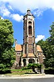
Evangelic church

Town hall


References[]
- ^ "Population of Municipalities – 1 January 2021". Czech Statistical Office. 2021-04-30.
- ^ "O městě" (in Czech). Město Hrob. Retrieved 2021-07-15.
External links[]
| Wikimedia Commons has media related to Hrob. |
| show Authority control |
|---|
This Ústí nad Labem Region location article is a stub. You can help Wikipedia by . |
Categories:
- Cities and towns in the Czech Republic
- Populated places in Teplice District
- Towns in the Ore Mountains
- Ústí nad Labem Region geography stubs