Košťany
Košťany | |
|---|---|
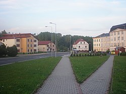 Mírové Square | |
 Flag  Coat of arms | |
 Košťany Location in the Czech Republic | |
| Coordinates: 50°39′33″N 13°45′26″E / 50.65917°N 13.75722°ECoordinates: 50°39′33″N 13°45′26″E / 50.65917°N 13.75722°E | |
| Country | |
| Region | Ústí nad Labem |
| District | Teplice |
| First mentioned | 1394 |
| Government | |
| • Mayor | Tomáš Sváda |
| Area | |
| • Total | 24.30 km2 (9.38 sq mi) |
| Elevation | 250 m (820 ft) |
| Population (2021-01-01)[1] | |
| • Total | 3,209 |
| • Density | 130/km2 (340/sq mi) |
| Time zone | UTC+1 (CET) |
| • Summer (DST) | UTC+2 (CEST) |
| Postal code | 417 23 |
| Website | www |

Košťany (Czech pronunciation: [ˈkoʃcanɪ], German: Kosten) is a town in Teplice District in the Ústí nad Labem Region of the Czech Republic. It has about 3,200 inhabitants.
Administrative parts[]
The town is divided into two administrative parts: Košťany and Střelná.
Geography[]
The urban area of Košťany lies below the Ore Mountains and the northern part of the municipal territory lies in the Ore Mountains. The highest peak in the municipal territory is Pramenáč with 909 metres (2,982 ft) above sea level.
History[]
The first written mention of Košťany is from 1394. In 1994 Košťany received the town status.[2]
Twin towns – sister cities[]
 Košťany nad Turcom, Slovakia
- Valaliky, Slovakia
References[]
- ^ "Population of Municipalities – 1 January 2021". Czech Statistical Office. 2021-04-30.
- ^ "Historie města" (in Czech). Město Košťany. Retrieved 2021-07-15.
- ^ "Košťanský zpravodaj 3/2019: Den města se vydařil" (PDF) (in Czech). Město Košťany. 2019-09-12. p. 2. Retrieved 2020-08-18.
External links[]
| Wikimedia Commons has media related to Košťany. |
| Authority control: National libraries |
|---|
This Ústí nad Labem Region location article is a stub. You can help Wikipedia by . |
Categories:
- Cities and towns in the Czech Republic
- Populated places in Teplice District
- Ústí nad Labem Region geography stubs