Borough of Tunbridge Wells
This article needs additional citations for verification. (April 2015) |
Borough of Tunbridge Wells | |
|---|---|
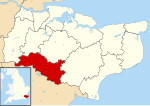 Tunbridge Wells shown within Kent | |
| Sovereign state | United Kingdom |
| Constituent country | England |
| Region | South East England |
| Non-metropolitan county | Kent |
| Status | Non-metropolitan district |
| Admin HQ | Royal Tunbridge Wells |
| Incorporated | 1 April 1974 |
| Government | |
| • Type | Non-metropolitan district council |
| • Body | Tunbridge Wells Borough Council |
| • Leadership | Leader & Cabinet (Conservative) |
| • MPs | Greg Clark Helen Grant |
| Area | |
| • Total | 127.9 sq mi (331.3 km2) |
| Area rank | 125th (of 309) |
| Population (mid-2019 est.) | |
| • Total | 118,724 |
| • Rank | 197th (of 309) |
| • Density | 930/sq mi (360/km2) |
| • Ethnicity | 95.1% White 1.4% S.Asian 1.1% Black 1.3% Mixed Race 1.0% Chinese or other |
| Time zone | UTC0 (GMT) |
| • Summer (DST) | UTC+1 (BST) |
| ONS code | 29UQ (ONS) E07000116 (GSS) |
| OS grid reference | TQ5817739112 |
| Website | www |

The Borough of Tunbridge Wells is a local government district and borough in Kent, England. It takes its name from its main town, Royal Tunbridge Wells.
The district was formed on 1 April 1974, by the merger of the municipal borough of Royal Tunbridge Wells along with Southborough urban district, Cranbrook Rural District and most of .
Description of borough[]
Location[]
The borough of Tunbridge Wells lies along the south western border of Kent, partly on the northern edge of the Weald, the remainder on the Weald Clay plain in the upper reaches of the rivers Teise and Beult.
The North Weald area[]
The restricted area immediately to the north and west of Tunbridge Wells lies within the Weald. The presence of sandstone outcrops and the chalybeate springs, together with old workings, point to ancient iron manufacturing in the area.
Weald Clay plain[]
This plain is part of the so-called Garden of England, named for its extensive orchards and former hop farms, sheep and cattle. A string of villages lies across this plain, from Brenchley and Horsmonden to Benenden and Headcorn.
Communications[]
- Roads The main roads through the borough are the A21 London to Hastings road and in the east, the A229, which runs from the A21 at Hurst Green through Cranbrook to Maidstone.
- Railways The line of the former South Eastern Railway (SER) main line crosses the clay plain in an almost unbroken straight line between Redhill and Ashford, Kent. The SER line to Hastings passes through Tunbridge Wells; here there was once a further branch connection south-eastwards to Groombridge, and at Paddock Wood is the southern terminus of the Medway Valley Line to Maidstone.
Borough organisation[]
Politics[]
In the 2016 European Union referendum, Tunbridge Wells was the only district in Kent that voted to remain in the EU (54.89%).
Places of interest[]
Apart from Tunbridge Wells itself, places of interest in the Borough include:
- Bedgebury Pinetum
- Bewl Water reservoir near Lamberhurst for leisure water pursuits and outdoor conferences
- Sissinghurst Castle gardens: the home of Vita Sackville-West
- facilities for rock-climbing at the 'High Rocks', 2 miles west of Tunbridge Wells
See also[]
References[]
External links[]

- Borough of Tunbridge Wells
- Non-metropolitan districts of Kent
- Politics of the Borough of Tunbridge Wells