Braithwaite, Louisiana
Braithwaite, Louisiana | |
|---|---|
 Braithwaite, Louisiana | |
| Coordinates: 29°51′59″N 89°56′37″W / 29.86639°N 89.94361°WCoordinates: 29°51′59″N 89°56′37″W / 29.86639°N 89.94361°W | |
| Country | United States |
| State | Louisiana |
| Parish | Plaquemines |
| Elevation | 7 ft (2 m) |
| Time zone | UTC-6 (Central (CST)) |
| • Summer (DST) | UTC-5 (CDT) |
| ZIP code | 70040 |
| Area code(s) | 504 |
| GNIS feature ID | 533365[1] |
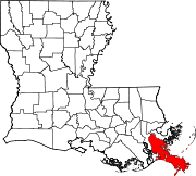
Braithwaite is an unincorporated community in Plaquemines Parish, Louisiana, United States. Braithwaite is located on the Mississippi River and Louisiana Highway 39 in northern Plaquemines Parish, 9.6 miles (15.4 km) southeast of New Orleans.[2] Braithwaite has a post office with ZIP code 70040, which opened on September 19, 1902.[3][4] Two of the first deaths in the United States caused by Hurricane Isaac in 2012 occurred in Braithwaite, where a couple drowned in their home on August 30.[5]
Education[]
Plaquemines Parish School Board operates public schools serving the community. The K-12 school Phoenix High School is in Braithwaite.[6]
See also[]
References[]
| Wikimedia Commons has media related to Braithwaite, Louisiana. |
- ^ "Braithwaite". Geographic Names Information System. United States Geological Survey.
- ^ Plaquemines Parish Northwest Section (PDF) (Map). Louisiana Department of Transportation and Development. 2012. Archived from the original (PDF) on August 30, 2012. Retrieved September 1, 2012.
- ^ United States Postal Service (2012). "USPS - Look Up a ZIP Code". Retrieved 2012-02-15.
- ^ "Postmaster Finder - Post Offices by ZIP Code". United States Postal Service. Retrieved September 1, 2012.
- ^ Todd, Brian; Greg Botelho (August 31, 2012). "Isaac leaves distress, perspective in southeastern Louisiana". CNN.com. Retrieved September 1, 2012.
- ^ "School Profile." Phoenix High School. Retrieved on December 3, 2016. "13073 Highway 15 Braithwaite, LA 70040"
Categories:
- Unincorporated communities in Plaquemines Parish, Louisiana
- Unincorporated communities in Louisiana
- Louisiana populated places on the Mississippi River
- Unincorporated communities in New Orleans metropolitan area
- Louisiana geography stubs


