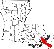
Davant, Louisiana

Davant is an unincorporated community located in the delta of the Mississippi River[1] in the parish of Plaquemines, Louisiana, United States.[2]
Geography[]

Davant's location is at 29°36′30″N 89°50′54″W / 29.60833°N 89.84833°W, located in the delta of the Mississippi River[citation needed], a sector where abuntan the swamps[citation needed]. This town stands at approximately 3 feet (0.91 m) above sea level.[3] Davant had some levees that protected the town from flooding, but were destroyed due to Hurricane Katrina.[4][citation needed]
Hurricane Katrina[]
The city was inundated by the water at the time of the hurricane, in 2005.[4][citation needed]
However, it was recently announced that it will receive $US 5,900,000 to rebuild, with new 15,000-square-foot (1,400 m2) homes in Davant.[5][citation needed]
References[]
- ^ "Wikimapia - Let's describe the whole world!". wikimapia.org.
- ^ "Davant, Louisiana". Geographic Names Information System. United States Geological Survey.
- ^ "Davant Populated Place Profile / Plaquemines Parish, Louisiana Data". louisiana.hometownlocator.com.
- ^ Jump up to: a b Roig-Franzia, Manuel (21 September 2005). "Ghost Town" – via www.washingtonpost.com.
- ^ "Davant, LA". Topix.
Coordinates: 29°36′30″N 89°50′54″W / 29.60833°N 89.84833°W
- Unincorporated communities in Plaquemines Parish, Louisiana
- Unincorporated communities in New Orleans metropolitan area
- Unincorporated communities in Louisiana
- Louisiana populated places on the Mississippi River
- Louisiana geography stubs
 WikiMiniAtlas