Breukelen
This article includes a list of references, related reading or external links, but its sources remain unclear because it lacks inline citations. (March 2013) |
Breukelen | |
|---|---|
Town and former municipality | |
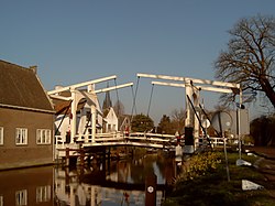 Bridge across the Vecht | |
 Flag  Coat of arms | |
 | |
| Coordinates: 52°10.3′N 5°0.1′E / 52.1717°N 5.0017°ECoordinates: 52°10.3′N 5°0.1′E / 52.1717°N 5.0017°E | |
| Country | Netherlands |
| Province | Utrecht |
| Municipality | Stichtse Vecht |
| Area (2006) | |
| • Total | 48.65 km2 (18.78 sq mi) |
| • Land | 44.48 km2 (17.17 sq mi) |
| • Water | 4.17 km2 (1.61 sq mi) |
| Population (1 January 2007) | |
| • Total | 14,635 |
| • Density | 329/km2 (850/sq mi) |
| Source: CBS, Statline. | |
| Time zone | UTC+1 (CET) |
| • Summer (DST) | UTC+2 (CEST) |
| Website | www.breukelen.nl |

Breukelen (Dutch pronunciation: [ˈbrøːkələ(n)] (![]() listen)) is a town and former municipality in the Netherlands, in the province of Utrecht. It is situated to the north west of Utrecht, along the river Vecht and close to the lakes of the Loosdrechtse Plassen, an area of natural and tourist interest. It is located in an area called the Vechtstreek.
It is the namesake of the borough of Brooklyn in New York City.
listen)) is a town and former municipality in the Netherlands, in the province of Utrecht. It is situated to the north west of Utrecht, along the river Vecht and close to the lakes of the Loosdrechtse Plassen, an area of natural and tourist interest. It is located in an area called the Vechtstreek.
It is the namesake of the borough of Brooklyn in New York City.
History[]
During the 17th century, many wealthy Amsterdam merchant families built their mansions along the river near Breukelen.[citation needed] On 1 January 2011 Breukelen merged with Loenen and Maarssen to form Stichtse Vecht. There is a large Van der Valk (Hotel Breukelen) hotel, the façade of which is in the Chinese style. Universiteit Nyenrode is located in Breukelen. In addition, the New York City borough of Brooklyn is named after Breukelen (see History of Brooklyn).
Public transport[]
- Breukelen railway station
- Bus services 120, 130, 143, 524 and 526
Population centres[]
The former municipality of Breukelen consisted of the following villages: Breukelen, Kockengen, and Nieuwer Ter Aa.
Gallery[]

Breukelen, castle/university Nijenrode

Breukelen, drawbridge across the Vecht
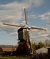
Breukelen, windmill


See also[]
- Film actor Rutger Hauer, who was born in Breukelen.
References[]
- Statistics are taken from the SDU Staatscourant
External links[]
| Wikimedia Commons has media related to Breukelen, Utrecht. |
| show Authority control |
|---|
This Utrecht location article is a stub. You can help Wikipedia by . |
- Populated places in Utrecht (province)
- Former municipalities of Utrecht (province)
- Stichtse Vecht
- Utrecht (province) geography stubs