Maarsseveen
Maarsseveen | |
|---|---|
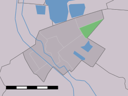
 Maarsseveen in the former municipality of Maarssen | |
| Coordinates: 52°8′27″N 5°4′25″E / 52.14083°N 5.07361°E | |
| Country | Netherlands |
| Province | Utrecht |
| Municipality | Stichtse Vecht |
Maarsseveen is a former hamlet in the Dutch province of Utrecht. It was located on the east bank of the , opposite the village of Maarssen, and has now been completely absorbed by that town. It makes part of the municipality of Stichtse Vecht.
From 1815 to 1949, Maarsseveen was a separate municipality. Apart from the village itself, the municipality covered the polder Maarsseveen, and the village of Oud-Maarsseveen.
External links[]
- J. Kuyper, Gemeente Atlas van Nederland, 1865-1870, "Maarsseveen". Map of the former municipality in 1868.
Coordinates: 52°08′27″N 5°04′25″E / 52.14083°N 5.07361°E
Categories:
- Populated places in Utrecht (province)
- Former municipalities of Utrecht (province)
- Stichtse Vecht
- Utrecht (province) geography stubs
