Bukovec, Myjava District
This article includes a list of references, related reading or external links, but its sources remain unclear because it lacks inline citations. (September 2018) |
Bukovec | |
|---|---|
Village | |
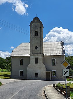
 Lutheran church in Bukovec | |
 Bukovec Location of Bukovec in the Trenčín Region | |
| Coordinates: 48°41′38″N 17°30′00″E / 48.694°N 17.500°ECoordinates: 48°41′38″N 17°30′00″E / 48.694°N 17.500°E | |
| Country | |
| Region | Trenčín |
| District | Myjava |
| First mentioned | 1609 |
| Area | |
| • Total | 15.469 km2 (5.973 sq mi) |
| Elevation | 380 m (1,250 ft) |
| Population | |
| • Total | 415 |
| • Density | 27/km2 (69/sq mi) |
| Time zone | UTC+1 (CET) |
| • Summer (DST) | UTC+2 (CEST) |
| Postal code | 906 14 |
| Car plate | MY |
| Website | www.bukovec.eu |
Bukovec (German: Bukowetz; Hungarian: Berencsbukócis) is a village and municipality in Myjava District in the Trenčín Region of north-western Slovakia.
History[]
In historical records the village was first mentioned in 1609.
Geography[]
The municipality lies at an altitude of 380 metres and covers an area of 15.469 km2. It has a population of about 415 people.
Genealogical resources[]
The records for genealogical research are available at the state archive "Statny Archiv in Bratislava, Slovakia"
- Roman Catholic church records (births/marriages/deaths): 1730-1952 (parish B)
- Lutheran church records (births/marriages/deaths): 1733-1949 (parish A)
See also[]
External links[]
 Media related to Bukovec (Myjava District) at Wikimedia Commons
- Official website

- https://web.archive.org/web/20071217080336/http://www.statistics.sk/mosmis/eng/run.html
- Surnames of living people in Bukovec
Categories:
- Villages and municipalities in Myjava District
- Trenčín geography stubs

