Buntingville, Eastern Cape
Buntingville | |
|---|---|
 Buntingville  Buntingville | |
| Coordinates: 31°38′20″S 28°52′08″E / 31.639°S 28.869°ECoordinates: 31°38′20″S 28°52′08″E / 31.639°S 28.869°E | |
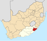
| Country | South Africa |
| Province | Eastern Cape |
| District | OR Tambo |
| Municipality | Nyandeni |
| Government | |
| • Councillor | Mbumbulwana |
| Area | |
| • Total | 3.44 km2 (1.33 sq mi) |
| Population (2011)[1] | |
| • Total | 1,090 |
| • Density | 320/km2 (820/sq mi) |
| Racial makeup (2011) | |
| • Black African | 99.8% |
| • Coloured | 0.1% |
| • Other | 0.1% |
| First languages (2011) | |
| • Xhosa | 98.3% |
| • Other | 1.7% |
| Time zone | UTC+2 (SAST) |
| PO box | 5115 |
Buntingville is a Methodist mission station 15 km south-east of Mthatha. Originally established by the Reverend W B Boyce in 1830 as Old Bunting near the village of the Pondo chief Faku at the headwaters of the , it was transferred about 1865. Named after Dr Jabez Bunting (1779-1858), the English Wesleyan church leader.[2]
References[]
- ^ a b c d "Main Place Buntingville". Census 2011.
- ^ Raper, Peter E. (1987). Dictionary of Southern African Place Names. Internet Archive. p. 99. Retrieved 28 August 2013.
Municipalities and communities of OR Tambo District Municipality, Eastern Cape | ||
|---|---|---|
District seat: Mthatha | ||
| Ingquza Hill |
|  |
| Port St Johns | ||
| Nyandeni |
| |
| Mhlontlo |
| |
| King Sabata Dalindyebo |
| |
Categories:
- Populated places in the Nyandeni Local Municipality
- 1830 establishments in South Africa
- Populated places established in 1830