Burgerbrug
Burgerbrug | |
|---|---|
Village | |
 | |
 | |
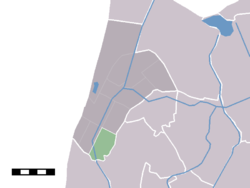 The statistical district (lightgreen) of Burgerbrug in the former municipality of Zijpe. | |
| Coordinates: 52°45′N 4°42′E / 52.750°N 4.700°ECoordinates: 52°45′N 4°42′E / 52.750°N 4.700°E | |
| Country | Netherlands |
| Province | North Holland |
| Municipality | Schagen |
| Population (2007) | |
| • Total | 475 |
| Time zone | UTC+1 (CET) |
| • Summer (DST) | UTC+2 (CEST) |

Burgerbrug is a village in the Dutch province of North Holland. It is a part of the municipality of Schagen, and lies about 14 km north of Alkmaar.
The statistical district "Burgerbrug" has a population of around 570.[1] Apart from the village itself, this also includes a part of the hamlet of , which is located on the border between Schagen and Bergen.
References[]
This North Holland location article is a stub. You can help Wikipedia by . |
Categories:
- Schagen
- Populated places in North Holland
- North Holland geography stubs