Butte Creek (Butte County, California)
| Butte Creek | |
|---|---|
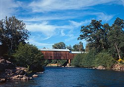 Honey Run Covered Bridge across Butte Creek | |
 Location of the mouth in California | |
| Location | |
| Country | United States |
| State | California |
| Counties | Butte, Glenn, Colusa, Sutter |
| Cities | Diamondville, Chico, Durham |
| Physical characteristics | |
| Source | Near Cirby Meadow |
| • location | About 5 miles (8.0 km) NE of Belden, Butte County |
| • coordinates | 40°04′45″N 121°22′26″W / 40.07917°N 121.37389°W[1] |
| • elevation | 6,260 ft (1,910 m) |
| Mouth | Sacramento River |
• location | Between Colusa and Meridian |
• coordinates | 39°11′41″N 121°56′11″W / 39.19472°N 121.93639°WCoordinates: 39°11′41″N 121°56′11″W / 39.19472°N 121.93639°W[1] |
• elevation | 52 ft (16 m)[1] |
| Length | 93 mi (150 km), North-south |
| Basin size | 560 sq mi (1,500 km2)est. |
| Discharge | |
| • location | Chico, CA[2] |
| • average | 411 cu ft/s (11.6 m3/s)[3] |
| • minimum | 44 cu ft/s (1.2 m3/s) |
| • maximum | 35,600 cu ft/s (1,010 m3/s) |
| Basin features | |
| River system | Sacramento River basin |
| Tributaries | |
| • left | Little Butte Creek (Butte County, California), Hamlin Slough, Cherokee Canal |

Butte Creek is tributary to the Sacramento River, joining the river in the vicinity of Colusa, California, United States. About 93 miles (150 km) in length,[4] it runs through much of Butte County, California (the county, however, receives its name from the Sutter Buttes in Sutter County, California). It travels through a spectacular mini-Grand Canyon as it reaches the Sacramento Valley floor, where it then flows somewhat south and west of the city of Chico towards the southwestern corner of the county.
Recent efforts have brought back Chinook salmon and steelhead runs to the stream.
There are several dams in its upper reaches. The PG&E has facilities at Centerville. The has Paradise Dam impounding Paradise Lake and the smaller Magalia Dam just beneath it on Little Butte Creek.
The creek was notable for the Honey Run Covered Bridge, which at 132 years old was the last remaining three-level covered bridge in the United States when it was destroyed on November 8, 2018 by the catastrophic Camp Fire.[5]
The , headquartered in Chico, California, is dedicated to preserving the history and beauty of the Butte Creek canyon. Whitewater kayaking on Butte Creek is popular, in part because of the outstanding scenery of the "Little Grand Canyon" section of the creek near Chico.
See also[]
- List of rivers in California
References[]
- ^ a b c "Butte Creek". Geographic Names Information System. United States Geological Survey. 1981-01-19. Retrieved 2010-11-06.
- ^ "USGS Gage #11390000 on Butte Creek near Chico, California" (PDF). National Water Information System. U.S. Geological Survey. 1931–2009. Retrieved 2010-11-06.
- ^ "USGS Gage #11390000 on Butte Creek near Chico, California" (PDF). National Water Information System. U.S. Geological Survey. 1931–2009. Retrieved 2010-11-06.
- ^ U.S. Geological Survey. National Hydrography Dataset high-resolution flowline data. The National Map Archived 2012-03-29 at the Wayback Machine, accessed March 10, 2011
- ^ "132-year-old Honey Run Covered Bridge, The Last of Its Kind, Destroyed By Wildfire". SFGate. 9 November 2018. Retrieved 2018-11-11.
External links[]
- Rivers of Butte County, California
- Tributaries of the Sacramento River
- Geography of the Sacramento Valley
- Rivers of Northern California