Caboolture, Queensland
| Caboolture Brisbane, Queensland | |||||||||||||||
|---|---|---|---|---|---|---|---|---|---|---|---|---|---|---|---|
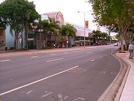 Caboolture CBD | |||||||||||||||
 Caboolture | |||||||||||||||
| Coordinates | 27°05′06″S 152°57′05″E / 27.085°S 152.9513°E | ||||||||||||||
| Population | 26,433 (2016 census)[1] | ||||||||||||||
| • Density | 384.76/km2 (996.5/sq mi) | ||||||||||||||
| Established | 1842 | ||||||||||||||
| Postcode(s) | 4510 | ||||||||||||||
| Area | 68.7 km2 (26.5 sq mi) | ||||||||||||||
| Time zone | AEST (UTC+10:00) | ||||||||||||||
| Location | 50 km (31 mi) north of Brisbane CBD | ||||||||||||||
| LGA(s) | Moreton Bay Region | ||||||||||||||
| State electorate(s) | |||||||||||||||
| Federal Division(s) | Longman | ||||||||||||||
| |||||||||||||||

Caboolture /kəˈbʊltʃər/[2] is a town and suburb in Moreton Bay Region, Queensland, Australia.[3][4] In the 2016 census, the suburb of Caboolture had a population of 26,433 people.[1] It is located on the north side of the Caboolture River, which separates the town from Morayfield and Caboolture South.
Geography[]
Caboolture is an urban centre or satellite city approximately 44 kilometres (27 mi) north of Brisbane, the state capital of Queensland. Caboolture is now considered to be the northernmost urban area of the greater Brisbane metropolitan region within South East Queensland, and it marks the end of the Brisbane suburban commuter railway service along the North Coast railway line.
The urban extent of the town of Caboolture is not formally defined but is generally regarded as including the following suburbs:[citation needed]
- Bellmere
- Caboolture (as a suburb)
- Caboolture South
- Morayfield (northern section, west of Bruce Highway)
- Upper Caboolture
History[]
Indigenous history[]
Duungidjawu (also known as Kabi Kabi, Cabbee, Carbi, Gabi Gabi) is an Australian Aboriginal language spoken on Duungidjawu country. The Duungidjawu language region includes the landscape within the local government boundaries of Somerset Region and Moreton Bay Region, particularly the towns of Caboolture, Kilcoy, Woodford and Moore.[5]
Gubbi Gubbi (Kabi Kabi, Cabbee, Carbi, Gabi Gabi) is an Australian Aboriginal language spoken on Gubbi Gubbi country. The Gubbi Gubbi language region includes the landscape within the local government boundaries of the Sunshine Coast Region and Gympie Region, particularly the towns of Caloundra, Noosa Heads, Gympie and extending north towards Maryborough and south to Caboolture.[6]
The Gubbi Gubbi people are the traditional custodians of the area now known as Caboolture. The name Kabultur is derived from the Yugarabul dialect meaning "place of the carpet snake".[7] The Gubbi Gubbi people harvested bush food, fresh water mussels, oysters, fish, and some game animals, moving around the land to take best advantage of seasonally-available produce.
Each year in March, the Gubbi Gubbi people would hold Bunya Festivals to feast on the plentiful and nutritious annual nuts of the Bunya Pine. These huge trees provided a food source which could sustain large numbers of people. Neighbouring clans were invited to the festivals, where singing, dancing story-telling, trading and arranging of marriages took place.[citation needed]
Towards the south of Caboolture is the Yugarabul traditional Aboriginal country of the Brisbane and surrounding regions.[8]
19th century[]
The Caboolture area was colonised by European people in 1842 when the land around the Moreton Bay penal colony was opened up to free settlers.[9]
By the mid-1860s the local pastoralists were experimenting with sugar cane and cotton. In 1867, a tiny settlement was established as a supply and trading centre for the settlers in the area and to service the needs of miners trekking from Brisbane to the goldfields near Gympie The local shire was constituted in 1879 and in 1888 the railway line from Brisbane was opened.[9]
Caboolture Post Office opened on 1 September 1869.[10]
Settlement in Caboolture was accelerated with the discovery of gold at Gympie. In 1868, the town was used as a stop-over point by the Cobb and Co coach service connecting Brisbane, Gympie and Maryborough. This function continued with the rail link established in 1888.[citation needed]
Caboolture State School opened on 4 August 1873. In 1890 it became Caboolture South State School. In 1908 it was became Morayfield State School.[11]
The foundation stone of St Laurence's Anglican Church was laid on Saturday 26 January 1889 by Mrs W.G. Geddies in a service conducted by Canon Glennie and . Mr W.G. Geddies, one of the oldest settlers in Caboolture had donated the land.[12][13] It was consecrated in 1959.[14] It was re-built and re-dedicated in 1982.[15]
Caboolture North State School opened on 25 November 1889. In June 1912 it became Caboolture State School in June 1912. Between 1940 and 1960 it was called Caboolture Rural State School. It had a secondary department from 1955 to 1961, after which a separate secondary school was established.[11]
20th century[]
On 5 December 1926 Roman Catholic Archbishop James Duhig laid the foundation stone for St Columban's College at "Highlands", 451 Sandgate Road, Albion in Brisbane.[16][17] The school officially opened on OSunday 29 January 1928. It was a school for boys operated by the Christian Brothers. In 1985 the Christian Brothers passed the management of the college to the Brisbane Diocese. This triggered a number of changes, a phasing out the primary school to focus on secondary schooling. In 1996 the school accepted enrolments from girls and in 1997 the school relocated to Caboolture.[11][18]
St Peter's Catholic School opened on 30 January 1951 in the parish church (now Mary McKillop Hall).[11] It was initially operated by the Sisters of St Joseph of the Sacred Heart under principal Sister Juan McGrath, assisted by Sister Timothy and Sister Salome.[19]
Caboolture State High School opened on 23 January 1961, replacing the secondary department that operated at Caboolture State School from 1955 to 1960.[11]
Caboolture Special School opened in January 1980 with 50 students who had previously been in the Special Education Unit at Caboolture State School.[11][20]
Caboolture East State School opened on 29 January 1980.[11]
St Michael's College opened on 25 January 1983 with 4 students in a small farmhouse.[11][21] It is associated with the Abbey Church of Christ the King, an Orthodox Catholic Church of Christ the King.[22][23]
St Paul's Lutheran Primary School opened in 1985.[24]
Tullawong State School opened on 1 February 1993.[11]
Tullawong State High School opened in January 1994.[11]
Caboolture Christian School opened in 1998.[11] In 2009 it was renamed Australian Christian College – Moreton.[25]
Harmony Montessori School opened in 1998.[11]
21st century[]
Grace Lutheran College Caboolture opened in 2008 adjacent to St Paul's Lutheran Primary School. The college is campus of Grace Lutheran College at Rothwell.[24]
The Caboolture Library opened in 2011.[26]
As part of the 30th Anniversary of Expo 88 celebration, on 26 October 2018, artist Ken Done unveiled the restoration of his iconic signs made for the Australia pavilion at Expo 88. It had spent the intervening years in a cow paddock beside the Bruce Highway at Deception Bay. The restoration was undertaken by the where they will remain on display.[27]
Caboolture has the unenviable title as one of Australia's "dole" capitals.[28] It is also known for its crime along with neighbouring suburbs.[29]
In the 2016 census, the suburb of Caboolture had a population of 26,433 people.[1]
Pumicestone State School opened on 1 January 2017.[30]
Heritage listings[]
Caboolture has a number of heritage-listed sites, including:
- Buckle Street: Lagoon Creek Pumping Station[31]
Population and demographics[]

| Year | Population | Notes |
|---|---|---|
| 1933 | 1,215 | |
| 1947 | 1,423 | |
| 1954 | 1,947 | |
| 1961 | 2,466 | |
| 1966 | 2,960 | |
| 1971 | 3,830 | |
| 1976 | 5,588 | |
| 1981 | 7,934 | |
| 1986 | 11,220 | |
| 1991 | 22,178 | |
| 1996 | 30,702 | |
| 2001 | 33,230 | |
| 2006 | 37,085 | |
| 2011 | 59,052 | [32] |
| 2016 | 67,460 | [33] |
According to the 2016 census of Population, there were 67,460 people in Caboolture
- Aboriginal and Torres Strait Islander people made up 4.8% of the population.
- 75.7% of people were born in Australia. The next most common countries of birth were New Zealand 4.6%, England 3.5%, Philippines 0.9%, Taiwan 0.6% and South Korea 0.5%.
- 85.8% of people spoke only English at home. Other languages spoken at home included Mandarin 0.8%, Samoan 0.6%, Tagalog 0.4%, Korean 0.4% and Cantonese 0.3%.
- The most common responses for religion were No Religion 33.2%, Catholic 19.0% and Anglican 15.7%.[33]
Transport[]
Caboolture is a regional transport hub. With its connections across the Great Dividing Range via the D'Aguilar Highway, easy highway access to Brisbane and the Sunshine Coast via the Bruce Highway, and the to Bribie Island.
Caboolture railway station is the terminus for QR Citytrain's Caboolture railway line, as well as being a major stop on the North Coast railway line. Citytrain operates regular services to Brisbane, in addition to interurban services to Nambour and Gympie. The area is serviced by two bus companies, Caboolture Bus Lines and the larger Kangaroo Bus Lines.
Caboolture also contains its own airfield, which primarily services general and recreational aviation. Visiting aircraft are able to operate into the Caboolture airstrip, which is under the operational control of the Caboolture Aero Club Inc. Additionally the airport is home to a number of aviation enterprises and attractions - amongst them, the Caboolture Warplane Museum (with operational P-51 Mustang, CAC Wirraway and CAC Winjeel aircraft), skydiving club, and the Beaufort Restoration group (a group of volunteers restoring an Australian-built DAP Beaufort Mark VII Bomber).
Sport[]
Caboolture's senior sporting teams predominantly play in the respective Sunshine Coast competitions. The suburbs cricket club are reigning Sunshine Coast Cricket Association first division premiers. The rugby union club have rejoined the Sunshine Coast Rugby Union competition after a few years in Queensland Suburban rugby's Barber Cup.[34]
The town also has a Little Athletics club.[35]
Education[]
State schools[]
Caboolture State School is a government primary (Prep-6) school for boys and girls at 12 George Street (27°04′57″S 152°56′55″E / 27.0825°S 152.9487°E). It includes a special education program.[36][37] In 2017, the school had an enrolment of 558 students with 41 teachers (37 full-time equivalent) and 39 non-teaching staff (26 full-time equivalent).[38]
Caboolture State High School is a government secondary (7-12) school for boys and girls at Lee Street (27°05′03″S 152°57′40″E / 27.0841°S 152.9610°E).[36][39] It includes a special education program. In 2017, the school had an enrolment of 1248 students with 110 teachers (107 full-time equivalent) and 57 non-teaching staff (44 full-time equivalent).[38]
Caboolture East State School is a government primary (Early Childhood-6) school for boys and girls at 44 Manley Street (27°04′39″S 152°57′39″E / 27.0775°S 152.9609°E). It includes a special education program and an early childhood developmental program.[36][40] In 2017, the school had an enrolment of 624 students with 54 teachers (49 full-time equivalent) and 54 non-teaching staff (34 full-time equivalent).[38]
Pumicestone State School is a government primary (Prep-6) school for boys and girls at 75 Cottrill Road (27°03′29″S 152°57′23″E / 27.058°S 152.9565°E). It includes a special education program.[36][41] In 2017, the school had an enrolment of 380 students with 27 teachers (25 full-time equivalent) and 17 non-teaching staff (13 full-time equivalent).[38]
Tullawong State School is a government primary (Prep-6) school for boys and girls at 60-94 Smiths Road (27°04′12″S 152°55′58″E / 27.0699°S 152.9327°E). It includes a special education program.[36][42] In 2017, the school had an enrolment of 757 students with 57 teachers (52 full-time equivalent) and 47 non-teaching staff (27 full-time equivalent).[38]
Tullawong State High School is a government secondary (7-12) school for boys and girls at Del Rosso Road (27°04′14″S 152°55′44″E / 27.0705°S 152.9289°E). It includes a special education program.[36][43] In 2017, the school had an enrolment of 912 students with 86 teachers (80 full-time equivalent) and 43 non-teaching staff (33 full-time equivalent).[38]
Lee Street State Special School is a government special education secondary school, which opened in 2020.[44]
Private schools[]
Alta-1 College is a private secondary (11-12) school for boys and girls at 94 Parish Road (27°04′16″S 152°56′29″E / 27.0710°S 152.9415°E).[36][45] In 2017, the school had an enrolment of 32 students with 3 teachers (2 full-time equivalent) and 5 non-teaching staff (4 full-time equivalent).[38]
Australian Christian College - Moreton is a private primary and secondary (Prep-12) school for boys and girls at 34 Cottrill Road (27°03′27″S 152°57′09″E / 27.0576°S 152.9525°E).[36][46] In 2017, the school had an enrolment of 1173 students with 47 teachers and 22 non-teaching staff (16 full-time equivalent).[38]
Caboolture Montessori School is a private primary (Prep-6) school for boys and girls at 200 Old Gympie Road (27°03′19″S 152°56′21″E / 27.0554°S 152.9392°E).[36][47] In 2017, the school had an enrolment of 139 students with 14 teachers (12 full-time equivalent) and 24 non-teaching staff (16 full-time equivalent).[38]
Grace Lutheran College Caboolture is a private secondary (7-12) campus at 129 Toohey Street (27°04′27″S 152°56′17″E / 27.0743°S 152.9381°E) of Grace Lutheran College at Rothwell. It operates in partnership with St Paul's Lutheran Primary School.[36][48][49]
Horizons College is a private secondary (9-12) school for boys and girls at 2 King Street (27°05′08″S 152°57′15″E / 27.0856°S 152.9541°E).[36][50] In 2017, the school had an enrolment of 110 students with 14 teachers (11 full-time equivalent) and 11 non-teaching staff (10 full-time equivalent).[38]
St Columban's College is a Catholic secondary (7-12) school for boys and girls at 100 McKean Street (27°04′44″S 152°57′46″E / 27.0790°S 152.9627°E).[36][51] In 2017, the school had an enrolment of 1004 students with 83 teachers (79 full-time equivalent) and 67 non-teaching staff (43 full-time equivalent).[38]
St Michael's College is a private primary (Prep-6) school for boys and girls at Jan-63 The Abbey Place (27°04′10″S 153°01′03″E / 27.0694°S 153.0174°E).[36][52] In 2017, the school had an enrolment of 335 students with 25 teachers (22 full-time equivalent) and 28 non-teaching staff (19 full-time equivalent).[38]
St Paul's Lutheran Primary School is a private primary (Prep-6) school for boys and girls at 55 Smith Road (27°04′19″S 152°55′58″E / 27.0720°S 152.9328°E). It operates in collaboration with Grace Lutheran College Caboolture.[36][53] In 2017, the school had an enrolment of 356 students with 23 teachers (21 full-time equivalent) and 28 non-teaching staff (19 full-time equivalent).[38]
St Peter's Catholic Primary School is a Catholic primary (Prep-6) school for boys and girls at 30 Beerburrum Road (27°04′49″S 152°57′06″E / 27.0803°S 152.9518°E).[36][54] In 2017, the school had an enrolment of 677 students with 42 teachers (38 full-time equivalent) and 27 non-teaching staff (18 full-time equivalent).[38]
Amenities[]
The Moreton Bay Regional Council operates a public library and art gallery at 4 Hasking Street.[55][56]
The Caboolture branch of the Queensland Country Women's Association meets at 10 George Street. It is one of the oldest in Queensland, having commenced in 1929.[57]
St Laurence's Anglican Church holds regular services at 165 King Street (27°05′02″S 152°56′21″E / 27.0838°S 152.9392°E).[58]
Caboolture Uniting Church is at 2-8 Smiths Road (corner King Street, 27°04′39″S 152°55′53″E / 27.0776°S 152.9314°E).[59][60] It is part of the Caboolture Region Uniting Church.[61]
New Hope Church meets at the Senior Citizens Centre at 24 Hasking Street (27°05′00″S 152°56′57″E / 27.0833°S 152.9493°E).[62] It is part of the Wesleyan Methodist Church.[63]
Governance[]
Caboolture was for most of its history the council seat of the Shire of Caboolture, however, the Shire merged into the Moreton Bay Region following statewide local government reforms in March 2008. Caboolture is divided between the electoral districts of Pumicestone and Morayfield in the Legislative Assembly of Queensland, and forms the main part of the Division of Longman in the Australian House of Representatives.
Attractions[]
The Caboolture Airfield is also home to the Caboolture Warplane and Heritage Museum. Included in their display is a collection of warbird and other vintage aircraft in flying condition. Currently, the collection includes a P-51D Mustang, SNJ and Winjeel as well as a French built World War I Nieuport 17 fighter, as well as displays of aviation memorabilia and aircraft engines.[64]
Events[]
Caboolture hosts an annual country music festival and a ute muster each year, called the Urban Country Music Festival.[65]
Notable people[]
This section needs additional citations for verification. (October 2015) |
- Paul Aiton, a Papua New Guinea rugby league captain
- Glen Boss, a jockey who has won the Melbourne Cup three times
- Andrew Lofthouse, a newsreader
- Rod Pampling, a PGA Tour professional golfer
- Keith Urban, a singer who was born in New Zealand, and moved to Caboolture, aged two years
- Corey Horsburgh, a rugby league player for the Canberra Raiders.
References[]
- ^ Jump up to: a b c Australian Bureau of Statistics (27 June 2017). "Caboolture (SSC)". 2016 Census QuickStats. Retrieved 20 October 2018.

- ^ Macquarie Dictionary, Fourth Edition (2005). Melbourne, The Macquarie Library Pty Ltd. ISBN 1-876429-14-3
- ^ "Caboolture – town in Moreton Bay Region (entry 5642)". Queensland Place Names. Queensland Government. Retrieved 19 September 2020.
- ^ "Caboolture – suburb in Moreton Bay Region (entry 50069)". Queensland Place Names. Queensland Government. Retrieved 19 September 2020.
- ^
 This Wikipedia article incorporates CC-BY-4.0 licensed text from: "Duungidjawu". Queensland Aboriginal and Torres Strait Islander languages map. State Library of Queensland. Retrieved 23 January 2020.
- ^ This Wikipedia article incorporates CC-BY-4.0 licensed text from: "Gubbi Gubbi". Queensland Aboriginal and Torres Strait Islander languages map. State Library of Queensland. Retrieved 23 January 2020.
- ^ South East Queensland - Place Names Archived 21 August 2006 at the Wayback Machine 2 January 2006
- ^ "AIATSIS code E66: Yugarabul". Federal government. Australian Institute of Aboriginal and Torres Strait Islander Studies. Archived from the original on 13 August 2020. Retrieved 31 July 2020.
- ^ Jump up to: a b History of our towns | Caboolture Shire Council Archived 16 August 2007 at the Wayback Machine
- ^ Premier Postal History. "Post Office List". Premier Postal Auctions. Archived from the original on 15 May 2014. Retrieved 10 May 2014.
- ^ Jump up to: a b c d e f g h i j k l Queensland Family History Society (2010), Queensland schools past and present (Version 1.01 ed.), Queensland Family History Society, ISBN 978-1-921171-26-0
- ^ "COUNTRY MAILS". The Brisbane Courier. XLV (9, 686). Queensland, Australia. 30 January 1889. p. 3. Archived from the original on 21 August 2021. Retrieved 22 May 2021 – via National Library of Australia.
- ^ "Dedicating the Anglican Church at Caboolture". Moreton Mail. 4 (162). Queensland, Australia. 1 February 1889. p. 2. Archived from the original on 21 August 2021. Retrieved 22 May 2021 – via National Library of Australia.
- ^ "General News". The Queenslander. XXXVI (721). Queensland, Australia. 27 July 1889. p. 170. Archived from the original on 22 May 2021. Retrieved 22 May 2021 – via National Library of Australia.
- ^ "Year Book" (PDF). Anglican Archdiocese of Brisbane. 2019. p. 136. Archived (PDF) from the original on 15 September 2020. Retrieved 15 September 2020.
- ^ "New Catholic School". The Telegraph (16, 852). Queensland, Australia. 6 December 1926. p. 9 (5 O'CLOCK CITY EDITION). Archived from the original on 24 September 2020. Retrieved 24 September 2020 – via National Library of Australia.
- ^ Universal Business Directories (Aust.) Pty. Ltd (1990). UBD street directory. Brisbane. Universal Business Directories (Australia). p. 27. Archived from the original on 24 August 2020. Retrieved 24 September 2020.
- ^ "History". St Columban's College. Archived from the original on 24 September 2020. Retrieved 24 September 2020.
- ^ "History". St Peter's Catholic School, Caboolture. Archived from the original on 24 September 2020. Retrieved 24 September 2020.
- ^ "History". Caboolture Special School. 27 April 2020. Archived from the original on 24 September 2020. Retrieved 24 September 2020.
- ^ St Michael's College (24 September 2020). "History". St. Michael's College. Archived from the original on 24 September 2020. Retrieved 24 September 2020.
- ^ "Abbey Church". St. Michael's College. 24 September 2020. Archived from the original on 24 March 2020. Retrieved 24 September 2020.
- ^ "History of the Church". Abbey Church, St Michael's Community. Archived from the original on 24 September 2020. Retrieved 24 September 2020.
- ^ Jump up to: a b "Our History". St Pauls Lutheran Primary School & Kindergarten. Archived from the original on 24 September 2020. Retrieved 24 September 2020.
- ^ "Australian Christian College - Moreton Annual Report". docplayer.net. Archived from the original on 21 August 2021. Retrieved 24 September 2020.
- ^ "Public Libraries Statistical Bulletin 2016-17" (PDF). Public Libraries Connect. State Library of Queensland. November 2017. p. 14. Archived (PDF) from the original on 30 January 2018. Retrieved 30 January 2018.
- ^ "Join us live for the unveiling of Expo 88's stacked Australia sign". ABC Radio Brisbane. 12 October 2018. Archived from the original on 15 November 2018. Retrieved 15 November 2018.
- ^ "Queensland Suburb Ruled Australia's Dole Bludging Capita". Triple M. 13 June 2017. Archived from the original on 3 November 2019. Retrieved 3 November 2019.
- ^ "CRIME RATES—CABOOLTURE, NARANGBA, NORTH LAKES". Vincent Security. Archived from the original on 3 November 2019. Retrieved 3 November 2019.
- ^ "Opening and closing dates of Queensland Schools". Queensland Government. Retrieved 24 September 2020.
- ^ "Lagoon Creek Railway Water Supply Facility and Pump Station (entry 602236)". Queensland Heritage Register. Queensland Heritage Council. Retrieved 11 July 2013.
- ^ Australian Bureau of Statistics (31 October 2012). "Caboolture (SA3)". 2011 Census QuickStats. Retrieved 7 October 2015.
- ^ Jump up to: a b Australian Bureau of Statistics (27 June 2017). "Caboolture (SA3)". 2016 Census QuickStats. Retrieved 3 October 2018.
 Material was copied from this source, which is available under a Creative Commons Attribution 4.0 International License Archived 16 October 2017 at the Wayback Machine.
- ^ "Gympie in Rugby A Grade 2020, Coolum get first 2A win". Around the Grounds. Sunshine Coast. 12 November 2018. Archived from the original on 24 March 2021. Retrieved 31 December 2018.
- ^ "Caboolture Little Athletics". Caboolture Little Athletics. Archived from the original on 13 March 2018. Retrieved 13 March 2018.
- ^ Jump up to: a b c d e f g h i j k l m n o "State and non-state school details". Queensland Government. 9 July 2018. Archived from the original on 21 November 2018. Retrieved 21 November 2018.
- ^ "Caboolture State School". Archived from the original on 29 April 2013. Retrieved 21 November 2018.
- ^ Jump up to: a b c d e f g h i j k l m n "ACARA School Profile 2017". Archived from the original on 22 November 2018. Retrieved 22 November 2018.
- ^ "Caboolture State High School". Archived from the original on 24 April 2019. Retrieved 21 November 2018.
- ^ "Caboolture East State School". Archived from the original on 24 September 2020. Retrieved 21 November 2018.
- ^ "Pumicestone State School". Archived from the original on 24 September 2020. Retrieved 21 November 2018.
- ^ "Tullawong State School". Archived from the original on 25 April 2013. Retrieved 21 November 2018.
- ^ "Tullawong State High School". Archived from the original on 27 July 2012. Retrieved 21 November 2018.
- ^ "Lee Street State Special School". Archived from the original on 8 December 2020. Retrieved 29 November 2020.
- ^ "Alta-1 College". Archived from the original on 6 October 2008. Retrieved 21 November 2018.
- ^ "Australian Christian College - Moreton". Archived from the original on 13 December 2018. Retrieved 21 November 2018.
- ^ "Caboolture Montessori School". Archived from the original on 27 December 2018. Retrieved 21 November 2018.
- ^ "Caboolture Campus". Grace Lutheran College. 24 September 2020. Archived from the original on 24 September 2020. Retrieved 24 September 2020.
- ^ "Grace Lutheran College". Archived from the original on 15 December 2018. Retrieved 21 November 2018.
- ^ "Horizons College". Archived from the original on 29 December 2018. Retrieved 21 November 2018.
- ^ "St Columban's College". Archived from the original on 19 August 2013. Retrieved 21 November 2018.
- ^ "St Michael's College". Archived from the original on 17 May 2018. Retrieved 21 November 2018.
- ^ "St Paul's Lutheran Primary School". Archived from the original on 4 November 2018. Retrieved 21 November 2018.
- ^ "St Peter's Catholic Primary School". Archived from the original on 4 March 2016. Retrieved 21 November 2018.
- ^ "Caboolture Library". Moreton Bay Regional Council. Archived from the original on 31 January 2018. Retrieved 30 January 2018.
- ^ "Caboolture Regional Art Gallery". Moreton Bay Regional Council. Archived from the original on 19 May 2019. Retrieved 3 April 2020.
- ^ "Branch Locations". Queensland Country Women's Association. Archived from the original on 26 December 2018. Retrieved 26 December 2018.
- ^ "Contact us". St. Laurence's Caboolture. Archived from the original on 24 September 2020. Retrieved 24 September 2020.
- ^ "Find a Church". Uniting Church in Australia, Queensland Synod. Archived from the original on 24 October 2020. Retrieved 22 November 2020.
- ^ "Caboolture Uniting Church". Churches Australia. Archived from the original on 29 August 2021. Retrieved 29 August 2021.
- ^ "Caboolture". Caboolture Region Uniting Church. 8 June 2012. Archived from the original on 16 April 2021. Retrieved 29 August 2021.
- ^ "New Hope". Wesleyan Methodist Church Australia. Archived from the original on 21 August 2021. Retrieved 21 August 2021.
- ^ "South Queensland". Wesleyan Methodist Church Australia. Archived from the original on 21 August 2021. Retrieved 21 August 2021.
- ^ Museum, Caboolture Warplane. "Museum". Caboolture Warplane Museum. Archived from the original on 27 January 2021. Retrieved 8 May 2021.
- ^ www.urbancountry.com.au Archived 18 November 2012 at the Wayback Machine
External links[]
| Wikimedia Commons has media related to Caboolture, Queensland. |
- "Caboolture". Queensland Places. Centre for the Government of Queensland, University of Queensland.
- "Town map of Caboolture". Queensland Government. 1985.
| show Queensland |
|---|
| show Authority control |
|---|
- Towns in Queensland
- Caboolture, Queensland
- South East Queensland
- Suburbs of Moreton Bay Region